Llanos Basin Coordinates 05°24′00″N 71°40′00″W / 5.40000°N 71.66667°W / 5.40000; -71.66667 Etymology Llanos Orientales Spanish : "eastern plains"Region Orinoquía Country Colombia State(s) Arauca , Boyacá , Casanare , Cundinamarca , Guainía , Guaviare , Meta , Norte de Santander Cities Villavicencio , Yopal On/Offshore Onshore Boundaries Colombia-Venezuela border (N), Guiana Shield (E), Vaupés Arch (S), Serranía de la Macarena (SW), Eastern Ranges (W)Part of Andean foreland basins Area 96,000 km2 (37,000 sq mi) River(s) Orinoco watershed Main rivers : Arauca , Meta , Guaviare , Vichada Basin type Foreland on rift basin [ note 1] Plate South American [ note 3] Orogeny Break-up of Pangea (Mesozoic)Andean (Cenozoic)Age Paleozoic or Jurassic [ note 2] Holocene Stratigraphy Stratigraphy Faults Eastern (W, bounding), Chichimene & Meta Field(s) Rubiales , Caño Limón , many more
The Llanos Basin (Spanish : Cuenca Llanos ) or Eastern Llanos Basin (Spanish : Cuenca de los Llanos Orientales ) is a major sedimentary basin of 96,000 square kilometres (37,000 sq mi) in northeastern Colombia . The onshore foreland on Mesozoic rift basin covers the departments of Arauca , Casanare and Meta and parts of eastern Boyacá and Cundinamarca , western Guainía , northern Guaviare and southeasternmost Norte de Santander . The northern boundary is formed by the border with Venezuela , where the basin grades into the Barinas-Apure Basin .
Description
The northeastern part of Colombia is characterized by its wavy plains, called Llanos Orientales , as part of the bigger Llanos that extend into Venezuela. The landscape is similar to a savanna and is poor in trees. It is located between the Eastern Ranges of the Colombian Andes in the west, the Vaupés Arch in the south and the Guiana Shield in the east.[ 1]
Geologically, the Llanos Basin underlies this typical landscape of the Llanos. An area where transport occurs mostly by small boats along the many rivers and the "buses of the Llanos", the Douglas DC-3 planes. The basin covers an area of 96,000 square kilometres (37,000 sq mi) and contains a stratigraphic column from the Paleozoic to recent.[ 2] source rocks (Gachetá , Los Cuervos , Carbonera C8 ), reservoir rocks (Mirador , Barco , Guadalupe and the uneven numbered members of Carbonera). Seals are formed by the shaly intervals (even numbered) of the Carbonera Formation, Los Cuervos, and León .[ 3]
The basin is the main petroleum producing basin of Colombia, with four of the nations biggest oil fields located in the Llanos Basin. Major fields are Rubiales , Colombia's biggest and most recent giant discovery sealed by a complex of hydrodynamic processes , and Caño Limón , at the border with Venezuela.
Major concerns in the basin for the production of petroleum are biodegradation , hydrocarbon migration , fault seal capacity and water flow.
Hydrography
Rivers of the Llanos BasinAriarí River The Llanos Basin is crossed by numerous rivers, all belonging to the Orinoco watershed . From north to south:
Flora and fauna
Fauna
Map of national parks in Orinoquía region Among other species, Lynch's swamp frog (Pseudopaludicola llanera epithet referring to the plains.[ 4] whip scorpion Mastigoproctus colombianus [ 5]
Geodynamic situation
Plate tectonic situation of northwestern South America.Nazca Plate has been subdivided into Coiba and Malpelo Plates Coiba & Malpelo Plates The country of Colombia spreads out over six tectonic plates , clockwise from north:
Caribbean Plate North Andes Plate South American Plate Malpelo Plate Coiba Plate Panama Plate The Llanos Basin is situated entirely on the South American Plate , bordering the North Andean Block or North Andean microplate in the west. The basin is one of three Colombian basins on the South American Plate, to the south the Caguán-Putumayo Basin and to the southeast the Vaupés-Amazonas Basin . The northern boundary of the Llanos Basin is formed by the Colombia-Venezuela border where the basin grades into the Barinas-Apure Basin on the Venezuelan side. The Catatumbo Basin , representing the Colombian portion of the larger Maracaibo Basin borders the Llanos Basin in the northwest and the western boundary is formed by the foothills (Piedemonte ) of the Eastern Cordillera Basin , the sedimentary basin covering the Eastern Ranges of the Colombian Andes .
Tectonics
The basin is bound to the west by the Eastern Frontal Fault System , a 921.4 kilometres (572.5 mi) long fault system connecting the North Andes and South American Plates and thus the Eastern Cordillera Basin and the Llanos Basin. The fault system has an average strike of 042.1±19, but this orientation varies greatly along its course. The 1827 , 1834 , 1917 , 1967 , 1995 , and 2008 earthquakes were all caused by fault movement as part of the system.[ 6]
Basin history
The tectonic history of the Llanos Basin, a foreland basin formed on top of Mesozoic rift basins , Paleozoic metasediments and Precambrian basement underlain by continental crust , goes back to the Early Jurassic .
The Andean orogeny , represented by the tectonic uplift of the Colombian Eastern Ranges and its northern extension, the Serranía del Perijá , caused tilting and uplift in the Llanos Basin. During the Andean orogenic phase, the paleotemperatures in the basin dropped considerably; in the Baja Guajira area from 115 °C (239 °F) in the Early Miocene to 70 °C (158 °F) in the Late Miocene.[ 7] Oca and Bucaramanga-Santa Marta Faults were tectonically active.[ 8]
Basement
The Cerros de Mavecure in Guainía are a remnant of the Proterozoic basement underlying the Llanos Basin The Serranía de Chiribiquete in Guaviare The stratigraphy of the Llanos Basin ranges, depending on the definition from either Jurassic or Paleozoic to recent. The basement is formed by the westernmost extensions of the Guiana Shield . Remnants of these Precambrian formations are found as inselbergs in the far east of Colombia (Cerros de Mavecure ), in the Serranía de la Macarena to the southwest of the basin and in the tepuis of the Serranía de Chiribiquete to the southeast.
The Proterozoic crystalline rocks are overlain by metamorphosed sedimentary and igneous rocks ranging in age from Cambrian to Devonian . Younger and contemporaneous Paleozoic deposits are only found in the subsurface and in regional correlative units as the Floresta and Cuche Formations of the Altiplano Cundiboyacense to the direct northwest and the Río Cachirí Group of the Cesar-Ranchería Basin farther northwest of the Llanos Basin.
The units found in the Llanos Basin pertain to the Farallones Group and comprise the Valle del Guatiquía Red Beds , Pipiral Shale and the Gutiérrez Sandstone .[ 9]
Stratigraphy
Stratigraphy of the Llanos Basin and surrounding provinces
Ma Age
Paleomap
Regional events Catatumbo Cordillera proximal Llanos
distal Llanos
Putumayo VSM Environments Maximum thickness Petroleum geology Notes
0.01 Holocene Holocene volcanismSeismic activity
alluvium
Overburden
1 Pleistocene Pleistocene volcanismAndean orogeny 3Glaciations
Guayabo Soatá Sabana Necesidad Guayabo Gigante Alluvial to fluvial (Guayabo)550 m (1,800 ft) [ 10] [ 11] [ 12] [ 13]
2.6 Pliocene Pliocene volcanism Andean orogeny 3GABI Subachoque
5.3 Messinian Andean orogeny 3Foreland Marichuela Caimán Honda [ 12] [ 14]
13.5 Langhian Regional flooding
León hiatus Caja León Lacustrine (León)400 m (1,300 ft) Seal [ 13] [ 15]
16.2 Burdigalian Miocene inundationsAndean orogeny 2
C1 Carbonera C1 Ospina Proximal fluvio-deltaic (C1)
850 m (2,790 ft) Reservoir [ 14] [ 13]
17.3 C2 Carbonera C2 Distal lacustrine-deltaic (C2)
Seal
19 C3 Carbonera C3 Proximal fluvio-deltaic (C3)
Reservoir
21 Early Miocene Pebas wetlands C4 Carbonera C4 Barzalosa Distal fluvio-deltaic (C4)
Seal
23 Late Oligocene Andean orogeny 1Foredeep C5 Carbonera C5 Orito Proximal fluvio-deltaic (C5)
Reservoir [ 11] [ 14]
25 C6 Carbonera C6 Distal fluvio-lacustrine (C6)
Seal
28 Early Oligocene C7 C7 Pepino Gualanday Proximal deltaic-marine (C7)
Reservoir [ 11] [ 14] [ 16]
32 Oligo-Eocene
C8 Usme C8 onlap Marine-deltaic (C8)
Seal Source [ 16]
35 Late Eocene Mirador Mirador Coastal (Mirador)
240 m (790 ft) Reservoir [ 13] [ 17]
40 Middle Eocene Regadera hiatus
45
50 Early Eocene Socha Los Cuervos Deltaic (Los Cuervos)
260 m (850 ft) Seal Source [ 13] [ 17]
55 Late Paleocene PETM 2000 ppm CO2 Los Cuervos Bogotá Gualanday
60 Early Paleocene SALMA Barco Guaduas Barco Rumiyaco Fluvial (Barco)
225 m (738 ft) Reservoir [ 10] [ 11] [ 14] [ 13] [ 18]
65 Maastrichtian KT extinction Catatumbo Guadalupe Monserrate Deltaic-fluvial (Guadalupe)
750 m (2,460 ft) Reservoir [ 10] [ 13]
72 Campanian End of rifting Colón-Mito Juan [ 13] [ 19]
83 Santonian Villeta /Güagüaquí
86 Coniacian
89 Turonian Cenomanian-Turonian anoxic event La Luna Chipaque Gachetá hiatus Restricted marine (all)
500 m (1,600 ft) Source [ 10] [ 13] [ 20]
93 Cenomanian Rift 2
100 Albian Une Une Caballos Deltaic (Une)500 m (1,600 ft) Reservoir [ 14] [ 20]
113 Aptian Capacho Fómeque Motema Yaví Open marine (Fómeque)
800 m (2,600 ft) Source (Fóm)[ 11] [ 13] [ 21]
125 Barremian High biodiversity Aguardiente Paja Shallow to open marine (Paja)
940 m (3,080 ft) Reservoir [ 10]
129 Hauterivian Rift 1 Tibú- Las Juntas hiatus Deltaic (Las Juntas)910 m (2,990 ft) Reservoir (LJun)[ 10]
133 Valanginian Río Negro Cáqueza Macanal Rosablanca Restricted marine (Macanal)
2,935 m (9,629 ft) Source (Mac)[ 11] [ 22]
140 Berriasian Girón
145 Tithonian Break-up of Pangea Jordán Arcabuco Buenavista Saldaña Alluvial , fluvial (Buenavista)110 m (360 ft) "Jurassic"
[ 14] [ 23]
150 Early-Mid Jurassic Passive margin 2 La Quinta Noreán hiatus Coastal tuff (La Quinta)
100 m (330 ft) [ 24]
201 Late Triassic Mucuchachi Payandé [ 14]
235 Early Triassic Pangea hiatus "Paleozoic"
250 Permian
300 Late Carboniferous Famatinian orogeny Cerro Neiva () [ 25]
340 Early Carboniferous Fossil fish Romer's gap Cuche (355-385) Farallones () Deltaic , estuarine (Cuche)900 m (3,000 ft)
360 Late Devonian Passive margin 1 Río Cachirí (360-419) Ambicá () Alluvial -fluvial -reef (Farallones)2,400 m (7,900 ft) [ 22] [ 26] [ 27] [ 28] [ 29]
390 Early Devonian High biodiversity Floresta (387-400) Shallow marine (Floresta)
600 m (2,000 ft)
410 Late Silurian Silurian mystery
425 Early Silurian hiatus
440 Late Ordovician Rich fauna in Bolivia San Pedro (450-490) Duda ()
470 Early Ordovician First fossils Busbanzá (>470±22 ) Guape () Río Nevado () [ 30] [ 31] [ 32]
488 Late Cambrian Regional intrusions
Chicamocha (490-515) Quetame () Ariarí () SJ del Guaviare (490-590) San Isidro () [ 33] [ 34]
515 Early Cambrian Cambrian explosion [ 32] [ 35]
542 Ediacaran Break-up of Rodinia pre-Quetame post-Parguaza El Barro () Yellow: allochthonous basementChibcha terrane )Río Negro-Juruena Province )
Basement [ 36] [ 37]
600 Neoproterozoic Cariri Velhos orogeny Bucaramanga (600-1400) pre-Guaviare [ 33]
800 Snowball Earth [ 38]
1000 Mesoproterozoic Sunsás orogeny Ariarí (1000) La Urraca (1030-1100) [ 39] [ 40] [ 41] [ 42]
1300 Rondônia-Juruá orogeny pre-Ariarí Parguaza (1300-1400) Garzón (1180-1550) [ 43]
1400 pre-Bucaramanga [ 44]
1600 Paleoproterozoic Maimachi (1500-1700) pre-Garzón [ 45]
1800 Tapajós orogeny Mitú (1800) [ 43] [ 45]
1950 Transamazonic orogeny pre-Mitú [ 43]
2200 Columbia
2530 Archean Carajas-Imataca orogeny [ 43]
3100 Kenorland
Sources
Legend group important formation fossiliferous formation minor formation (age in Ma) proximal Llanos (Medina)[ note 4]
distal Llanos (Saltarin 1A well)[ note 5]
Paleozoic
Cambro-Ordovician Pre-Devonian Devonian
Jurassic
Petroleum geology
The Llanos Basin is the most prolific hydrocarbon basin of Colombia, hosting well-known petroleum deposits as Caño Limón , Rubiales and other fields. Nine of the twenty most producing oil fields of Colombia are situated in the Llanos Basin.
Fields
Based on data released in March 2018, Colombia is the 21st oil producer in the world. Daily production dropped in 2017 to 854.121 thousand barrels per day (135.7944×10 ^ 3 m3 /d).[ 50] [ 51] ×10 ^ 6 m3 ) in 2016.[ 52]
Major oil fields in the Llanos Basin are:[ 53]
Other fields[ 53] Caño Verde
Chaparrito
Concesión
Corcel
Cravo Sur
La Gloria
Santiago
Trinidad
Valdivia
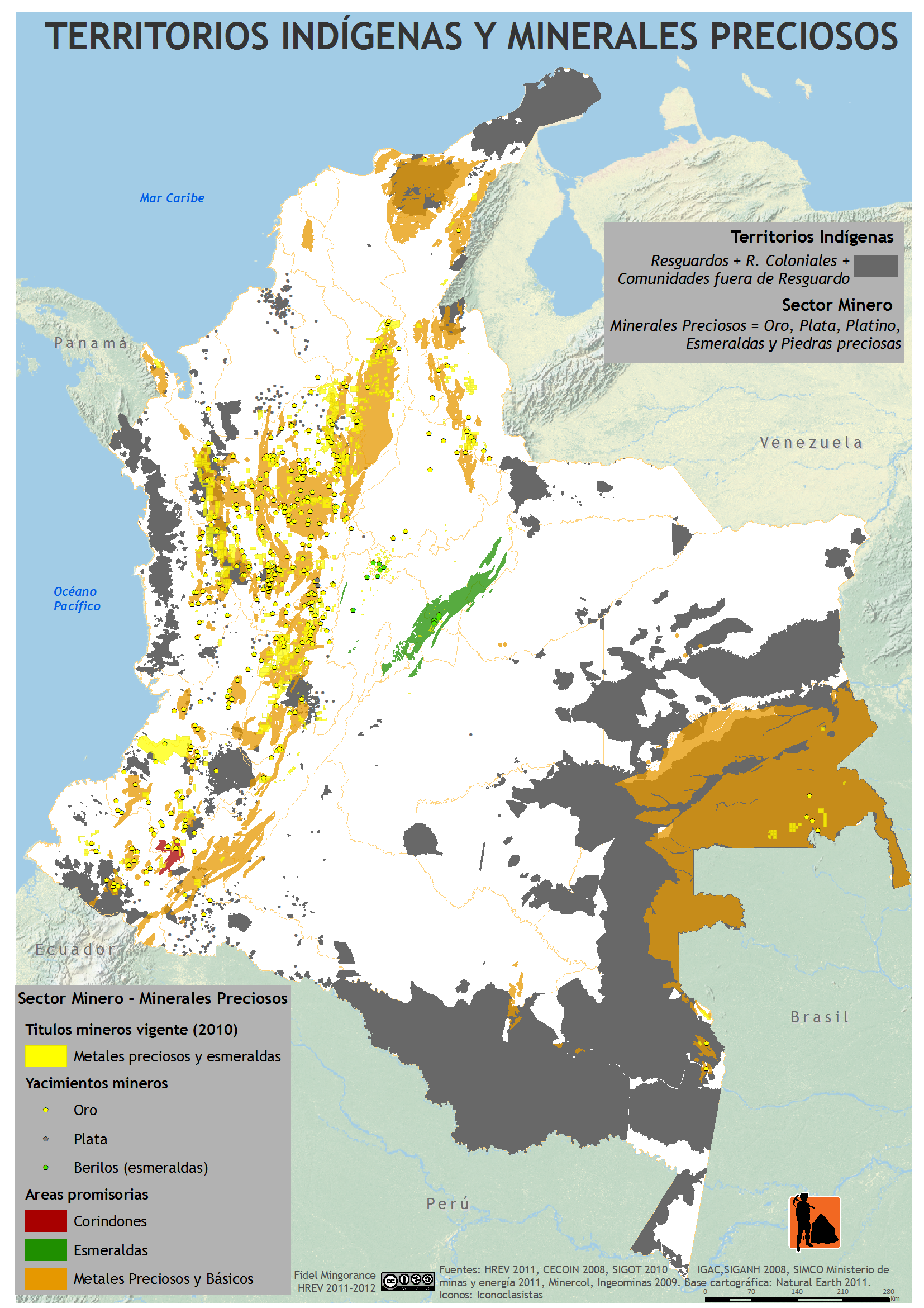
Mining
Mining activities in the Llanos Basin are restricted to certain areas, resulting in less conflicts, more common with indigenous peoples in the Amazonian part of Colombia.[ 61]
In San José del Guaviare platinum is mined.[ 65]
Mining in the Llanos Basin and surrounding areas
Resources
Map
Department
Municipality
Mine
Notes
halite Meta Restrepo Upín
[ 63] [ 66]
gold Puerto Rico [ 62]
Arauca Arauca
gold Guaviare San José del Guaviare
platinum , iron albite , andradite (var: melanite ), 'apatite ', arfvedsonite , 'biotite ', calcite , cancrinite , epidote , fluorite , 'garnet ', microcline , 'monazite ', nepheline , siderite , titanite , zircon [ 65] [ 67]
coal Casanare Recetor [ 64]
Paleontology
Compared to many fossiliferous formations in Colombia, the Llanos Basin has been lean in fossil content. Most of the basin stratigraphy is only known from wells.
Paleozoic outcrops surrounding and perforating the planar geography have provided fossils dating back to the Cambrian ; the Duda and Ariarí Formations .
Several fossiliferous formations of contemporaneous depositional environments have provided many unique fossils indicative of paleoclimatic conditions; turtle fossils were described from Los Cuervos in the Cesar-Ranchería Basin, and the Mirador Formation in the Catatumbo Basin direct northwest of the Llanos Basin has provided many fossil flora.[ 68]
Other correlative units with surrounding basins
See also
Sources
Notes
^ More detailed: continental margin (Protero- and Paleozoic), rift basin (Mesozoic), foredeep (Paleogene and early Neogene), foreland (late Neogene to recent)
^ Depending on the definition of basement , the stratigraphic succession starts either in the Paleozoic on Proterozoic crystalline basement or Jurassic on top of both
^ The northernmost of three Colombian basins on this plate, to the south the Caguán-Putumayo and Vaupés-Amazonas Basins
^ based on Duarte et al. (2019)[ 46] [ 47] [ 48]
^ based on Duarte et al. (2019)[ 46] UIS and ANH in 2009[ 49]
References
^ Barrero et al., 2007, p.69
^ ANH, 2010
^ García González et al., 2009, p.58
^ Pseudopaludicola llanera IUCN .org^ Mastigoproctus colombianus GBIF .org^ Paris et al., 2000a, p.36
^ Hernández Pardo et al., 2009, p.122
^ Hernández Pardo et al., 2009, p.28
^ Plancha 266, 1998
^ a b c d e f García González et al., 2009, p.27
^ a b c d e f García González et al., 2009, p.50
^ a b García González et al., 2009, p.85
^ a b c d e f g h i j Barrero et al., 2007, p.60
^ a b c d e f g h Barrero et al., 2007, p.58
^ Plancha 111, 2001, p.29
^ a b Plancha 177, 2015, p.39
^ a b Plancha 111, 2001, p.26
^ Plancha 111, 2001, p.24
^ Plancha 111, 2001, p.23
^ a b Pulido & Gómez, 2001, p.32
^ Pulido & Gómez, 2001, p.30
^ a b Pulido & Gómez, 2001, pp.21-26
^ Pulido & Gómez, 2001, p.28
^ Correa Martínez et al., 2019, p.49
^ Plancha 303, 2002, p.27
^ Terraza et al., 2008, p.22
^ Plancha 229, 2015, pp.46-55
^ Plancha 303, 2002, p.26
^ Moreno Sánchez et al., 2009, p.53
^ Mantilla Figueroa et al., 2015, p.43
^ Manosalva Sánchez et al., 2017, p.84
^ a b Plancha 303, 2002, p.24
^ a b Mantilla Figueroa et al., 2015, p.42
^ Arango Mejía et al., 2012, p.25
^ Plancha 350, 2011, p.49
^ Pulido & Gómez, 2001, pp.17-21
^ Plancha 111, 2001, p.13
^ Plancha 303, 2002, p.23
^ Plancha 348, 2015, p.38
^ Planchas 367-414, 2003, p.35
^ Toro Toro et al., 2014, p.22
^ Plancha 303, 2002, p.21
^ a b c d Bonilla et al., 2016, p.19
^ Gómez Tapias et al., 2015, p.209
^ a b Bonilla et al., 2016, p.22
^ a b Duarte et al., 2019
^ García González et al., 2009
^ Pulido & Gómez, 2001
^ García González et al., 2009, p.60
^ Producción de crudo bajó en 30.879 barriles por día en 2017 - El Tiempo ^ En 20 campos se produce el 66 % del petróleo del país - El Tiempo ^ Oil reserves per department - 2016 - ANH ^ a b Mojica et al., 2009, p.30
^ ANH & Halliburton, s.a., p.2
^ Castilla, área petrolera especial - El Tiempo ^ ANH & Halliburton, s.a., p.3
^ Chichimene ^ Las reservas de campo Quifa se reducen en 5,9 millones de barriles ^ a b Mapa de Tierras, ANH, 2017
^ Caño Limón ^ (in Spanish) Mapa de Territorios Indígenas y Minerales Preciosos ^ a b (in Spanish) Producción de oro – UPME ^ a b (in Spanish) Producción de sal – UPME ^ a b (in Spanish) Producción de carbón – UPME ^ a b (in Spanish) Producción de platino – UPME ^ Upin at Mindat .org^ San José del Guaviare at Mindat .org^ Jaramillo & Dilcher, 2001
Bibliography
General
Barrero, Dario; Pardo, Andrés; Vargas, Carlos A.; Martínez, Juan F. (2007), Colombian Sedimentary Basins: Nomenclature, Boundaries and Petroleum Geology, a New Proposal , ANH , pp. 1– 92 García González, Mario; Mier Umaña, Ricardo; Cruz Guevara, Luis Enrique; Vásquez, Mauricio (2009), Informe Ejecutivo - evaluación del potencial hidrocarburífero de las cuencas colombianas , Universidad Industrial de Santander , pp. 1– 219
Hydrodynamics
Mora, Andrés; Gómez, Ricardo Andrés; Díaz, Camilo; Caballero, Victor; Parra, Mauricio; Villamizar, Carlos; Lasso, Álvaro; Ketcham, Richard A.; González Penagos, John Rico and Juan Pablo Arias Martínez, Felipe (2019), "Water flow, oil biodegradation, and hydrodynamic traps in the Llanos Basin, Colombia" , AAPG Bulletin 103 (5): 1225– 1264, Bibcode :2019BAAPG.103.1225M , doi :10.1306/1003181611317237 , retrieved 2019-10-26 Duarte, Edward; Bayona, German; Jaramillo, Carlos ; Parra, Mauricio; Romero, Ingrid; Mora, Josué Alejandro (2017), "Identificación de los máximos eventos de inundación marina Miocenos y su uso en la correlación y análisis de la cuenca de antepaís de los Llanos Orientales, Colombia" , Boletín de Geología 39 : 19– 40, doi :10.18273/revbol.v39n1-2017001 , retrieved 2019-10-26 Bartha, Attila; De Nicolais, Nelly; Sharma, Vinod; Roy, S.K.; Srivastava, Rajiv; Pomerantz, Andrew E.; Sanclemente, Milton; Pérez, Wilmar; Nelson, Christopher M. Reddy, Jonas Gros, J. Samuel Arey, Jaron Lelijveld, Sharad Dubey, Diego Tortella, Thomas Hantschel, Kenneth E. Peters and Oliver C. Mullins, Robert K. (2015), "Combined Petroleum System Modeling and Comprehensive Two-Dimensional Gas Chromatography To Improve Understanding of the Crude Oil Chemistry in the Llanos Basin, Colombia" , Energy & Fuels , 29 (8): 4755– 4767, doi :10.1021/acs.energyfuels.5b00529 , retrieved 2019-10-26 {{citation }}: CS1 maint: multiple names: authors list (link )Gómez Galarza, Yohaney; Yoris, Franklin; Rodríguez, Javier; Portillo, Fredy; Araujo, Ysidro (2010), "Aspectos hidrodinámicos, estructurales y estratigráficos del Campo Rubiales" (PDF) , Geo Petróleo , 9 : 1– 28, retrieved 2017-06-07 Gómez, A.; Jaramillo, C. ; Parra, M.; Mora, A. (2009), "Huesser Horizon: A lake and marine incursion in Northwestern South America during the Early Miocene" , PALAIOS 24 (4): 199– 210, Bibcode :2009Palai..24..199G , doi :10.2110/palo.2007.p07-074r , retrieved 2019-10-26
Tectonics
Paris, Gabriel; Machette, Michael N.; Dart, Richard L.; Haller, Kathleen M. (2000a), Map and Database of Quaternary Faults and Folds in Colombia and its Offshore Regions (PDF) , USGS , pp. 1– 66, retrieved 2017-09-18 Paris, Gabriel; Machette, Michael N.; Dart, Richard L.; Haller, Kathleen M. (2000b), Map of Quaternary Faults and Folds of Colombia and Its Offshore Regions (PDF) , USGS , p. 1, retrieved 2017-09-18
Petroleum
Martínez Sánchez, Dilan; Jiménez, Giovanny (2019), "Hydraulic fracturing considerations: Insights from analogue models, and its viability in Colombia" , Earth Sciences Research Journal 23 : 5– 15, doi :10.15446/esrj.v23n1.69760 , retrieved 2019-10-26 ISSN 1794-6190 Vargas Jiménez, Carlos A (2012), "Evaluating total Yet-to-Find hydrocarbon volume in Colombia", Earth Sciences Research Journal 16 : 1– 290 Mojica, Jairo ; Arévalo, Oscar J.; Castillo, Hardany (2009), Cuencas Catatumbo, Cesar – Ranchería, Cordillera Oriental, Llanos Orientales, Valle Medio y Superior del Magdalena (PDF) , ANH , pp. 1– 65, retrieved 2017-06-14 Piedrahita, Carlos; Montaña, Clara L. (2007), "Methodology implemented for the 3D-Seismic modelling using GoCad and NORSAR 3D Software applied to complex areas in the Llanos foothills" , Earth Sciences Research Journal 11 : 35– 43, retrieved 2019-10-26 Hernández Pardo, Orlando; von Frese, Ralph R.B.; Woo Kim, Jeong (2007), "Crustal thickness variations and seismicity of northwestern South America" , Earth Sciences Research Journal 11 : 81– 94, retrieved 2019-10-26 N., N (2006), Cuenca Llanos Orientales - Estudio Integrado - Crudos Pesados (PDF) , ANH , pp. 1– 10, retrieved 2017-06-07
Paleontology
Reports
Pinto Valderrama, Jorge Eduardo; Mora Ortiz, José Pedro; Reátiga Tarazona, Gloria; Rey Pilonieta, Jorge Alberto; Toloza Hormiga, Silvia Johana; Torres Coronado, Diego Andrés; Vargas Mojica, David Ricardo; Zafra Manrique, Cristian Julián (2010), Geología del Piedemonte Llanero en la Cordillera Oriental, departamentos de Arauca y Casanare (PDF) , INGEOMINAS & Universidad Industrial de Santander , pp. 1– 64, retrieved 2017-08-04 Terraza, Roberto; Montoya, Diana; Reyes, Germán; Moreno, Giovanni; Fúquen, Jaime; Torres Jaimes, Eliana; López Cardona, Myriam; Nivia Guevara, Álvaro; Etayo Serna, Fernando (2013), Geología de la Plancha 229 - Gachalá - 1:100,000 (PDF) , Servicio Geológico Colombiano , pp. 1– 296, retrieved 2017-08-04 Patiño, Alejandro; Fuquen, Jaime; Ramos, Julián; Pedraza, Andrea; Ceballos, Leonardo; Pinzón, Lyda; Jerónimo, Yadira; Álvarez, Leidy; Torres, Andrea (2011), Cartografía geológica de la Plancha 247 - Cáqueza - 1:100,000 (PDF) , INGEOMINAS , retrieved 2017-08-04 Acosta, Jorge E.; Ulloa, Carlos E. (2002), Mapa geológico del Departamento de Cundinamarca 1:250,000 - Memoria Explicativa , INGEOMINAS , pp. 1– 108 Pulido, Orlando; Gómez, Luz Stella (2001), Geología de la Plancha 266 - Villavicencio - 1:100,000 , INGEOMINAS , pp. 1– 52
Maps
Departmental Reyes, Germán; Cardozo, Ana Milena (1999), Mapa Geológico de Arauca 1:250,000 INGEOMINAS , p. 1, retrieved 2017-09-21 Acosta, Jorge; Ulloa, Carlos; García, Pilar; Solano, Orlando (1999), Mapa Geológico de Cundinamarca INGEOMINAS , p. 1, retrieved 2017-09-21 Rodríguez, Antonio José (2002), Mapa Geológico del Meta 1:500,000 INGEOMINAS , p. 1, retrieved 2017-09-21 Local Fúquen, Jaime; Ceballos, Leonardo; Pedraza, Andrea; Marín, Edwin (2010), Plancha 99 - Villa del Rosario - 1:100,000 (PDF) , INGEOMINAS , p. 1, retrieved 2018-06-01 Royero, José María; Zambrano, J.; Daconte, Rommel; Mendoza, H.; Vargas, Rodrigo (1999), Plancha 111 - Toledo - 1:100,000 INGEOMINAS , p. 1, retrieved 2017-06-06 Daconte B., Rommel; Salinas E, Rosalba (1982), Plancha 122 - Río Cobugón - 1:100,000 (PDF) , INGEOMINAS , p. 1, retrieved 2018-06-01 Vargas, Rodrigo; Arias, Alfonso; Jaramillo, Luis; Tellez, Noel (1984), Plancha 136 - Málaga - 1:100,000 INGEOMINAS , p. 1, retrieved 2017-06-06 López, Carolina; Dávila, Camilo; González, Francisco; Parra, Eduardo; Chaquea, Claudia; Ojeda, Carolina; Q., Carlos; Espinel, Valentina; Lancheros, José A. (2011), Plancha 139 - Betoyes - 1:100,000 INGEOMINAS , p. 1, retrieved 2017-06-06 López, Carolina; Dávila, Camilo; González, Francisco; Parra, Eduardo; Chaquea, Claudia; Ojeda, Carolina; Q., Carlos; Espinel, Valentina; Lancheros, José A. (2011), Plancha 155 - Puerto Rondón - 1:100,000 INGEOMINAS , p. 1, retrieved 2017-06-06 Ulloa, Carlos E.; Rodríguez, Erasmo; Escovar, Ricardo (1998), Plancha 192 - Laguna de Tota - 1:100,000 INGEOMINAS , p. 1, retrieved 2017-06-06 Terraza, Roberto; Moreno, Giovanni; Buitrago, José A.; Pérez, Adrián; Montoya, Diana María (2010), Plancha 210 - Guateque - 1:100,000 INGEOMINAS , p. 1, retrieved 2017-06-06 Buitrago, José Alberto; Terraza M., Roberto; Etayo, Fernando (1998), Plancha 228 - Santafé de Bogotá Noreste - 1:100,000 INGEOMINAS , p. 1, retrieved 2017-06-06 Ulloa, Carlos E; Escovar, Ricardo; Pacheco, Adolfo H. (2009), Plancha 230 - Monterrey - 1:100,000 INGEOMINAS , p. 1, retrieved 2017-06-06 Acosta, Jorge; Calcedo, Juan Carlos; Ulloa, Carlos (1999), Plancha 265 - Icononzo - 1:100,000 INGEOMINAS , p. 1, retrieved 2017-06-06 Pulido, Orlando; Gómez, Luz Stella; Marín, Pedro (1998), Plancha 266 - Villavicencio - 1:100,000 INGEOMINAS , p. 1, retrieved 2017-06-06 Duarte, Rafael; Moreno, Mauricio; Morales, Carlos Julio; Villegas, Henry; Alvarado, Sonia; Téllez, Milena; Pacheco, Sonia; Rojas, Nadia (2010), Plancha 267 - Pachaquiaro - 1:100,000 INGEOMINAS , p. 1, retrieved 2017-06-06 Unión Temporal, G&H (2015), Plancha 284 - Santana - 1:100,000 (PDF) , Servicio Geológico Colombiano , p. 1, retrieved 2018-06-01
Further reading
Bally, A.W.; Snelson, S. (1980), "Realms of subsidence", Canadian Society for Petroleum Geology Memoir , 6 : 9– 94 Kingston, D.R.; Dishroon, C.P.; Williams, P.A. (1983), "Global Basin Classification System" (PDF) , AAPG Bulletin 67 : 2175– 2193, retrieved 2017-06-23 Klemme, H.D (1980), "Petroleum Basins - Classifications and Characteristics", Journal of Petroleum Geology 3 (2): 187– 207, Bibcode :1980JPetG...3..187K , doi :10.1111/j.1747-5457.1980.tb00982.x
Sedimentary basins of Colombia
Onshore
Western Region Central Region Eastern Region
Offshore Source Barrero, Dario; Pardo, Andrés; Vargas, Carlos A.; Martínez, Juan F. (2007). Colombian Sedimentary Basins: Nomenclature, Boundaries and Petroleum Geology, a New Proposal . ANH . pp. 1– 92.


.JPG)


