Guilin is one of China's most popular tourist destinations,[3] and the epithet "By water, by mountains, most lovely, Guilin" (山水甲天下)[4] is often associated with the city. The State Council of China has designated Guilin a National Famous Historical and Cultural City, doing so in the first edition of the list.
History
Before the Qin dynasty, the Guilin region was settled by the Baiyue people.[5] In 314 BC, a small settlement was established along the banks of the Li River.[6]
During the Qin dynasty's (221–206 BC) campaigns against the state of Nanyue, the first administration was set up in the area around Guilin.[7] The modern city was located within the Guilin Commandery, which is the origin of the modern name "Guilin".
In 111 BC, during the reign of Emperor Wu of the Han dynasty, Shi'an County (simplified Chinese: 始安县; traditional Chinese: 始安縣) was established, which could be regarded as the beginning of the city.
In AD 507, the town was renamed Guizhou (Gui Prefecture, 桂州).[5]
In 634, Lingui County was established at the modern site of Guilin, under Gui Prefecture. In 868, Pang Xun rebelled against the Tang from Gui Prefecture.[5]
Guilin prospered in the Tang and Song dynasties but remained a county. The city was also a nexus between the central government and the southwest border, and it was where regular armies were placed to guard that border. Canals were built through the city so that food supplies could be directly transported from the food-productive Yangtze plain to the farthest southwestern point of the empire.
In 997, Guangnan West Circuit, the predecessor of modern Guangxi, was established, with Guizhou as the capital. In 1133, Guizhou was renamed Jingjiang Prefecture (simplified Chinese: 静江路; traditional Chinese: 靜江路). In 1367, the name was changed to Guilin Prefecture (桂林府).[5]
In 1921, Guilin became one of the headquarters of the Northern Expeditionary Army led by Sun Yat-sen.[8] In 1940, Guilin City was established.[9][10] Guilin was the provincial capital of Guangxi before 1912 and from 1936 to 1949.
Guilin became one of the most important military, transport, and cultural centers of China during World War II. The city drastically expanded as refugees from all over China poured in, and by 1944 its population had grown from 70,000 pre-war to more than 500,000. It hosted intellectuals and artists including Guo Moruo, Mao Dun, Ba Jin, Tian Han, Xu Beihong, Feng Zikai and many others.[11]
In 1950, the provincial capital of Guangxi was moved from Guilin to Nanning.
In 1981, Guilin was listed by the State Council as one of the four cities (the other three being Beijing, Hangzhou, and Suzhou) where the protection of historical and cultural heritage, as well as natural scenery, should be treated as a priority project.[12][13]
Map including Guilin (labeled as 桂林 KUEI-LIN (KWEILIN) (Walled)) (AMS, 1954)
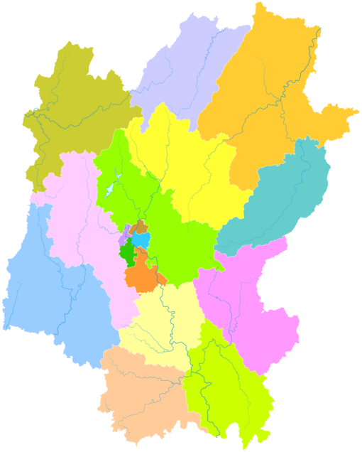
Guilin is located in northern Guangxi, bordering Liuzhou to the west, Laibin to the southwest, Wuzhou to the south, Hezhou to the southeast, and within neighbouring Hunan, Huaihua to the northwest, Shaoyang to the north, and Yongzhou to the east. It has a total area of 27,809 square kilometres (10,737 sq mi). The topography of the area is marked by karst formations. The karsts surrounding Guilin are made of Triassic period limestone and dolomite rocks. The Li River flows through the city.
Hills and mountains: Diecai Hill (叠彩山), Elephant Trunk Hill, Wave-Subduing Hill (伏波山), Lipu Mountains, Kitten Mountain, the highest peak of Guangxi, and Yao Hill (尧山)
Guilin has a monsoon-influenced humid subtropical climate (KöppenCfa, bordering on Cwa), with short, mild winters, and long, hot, humid summers. Winter begins dry but becomes progressively wetter and cloudier. Spring is generally overcast and often rainy, while summer continues to be rainy though is the sunniest time of year. Autumn is sunny and dry. The monthly 24-hour average temperature ranges from 8.1 °C (46.6 °F) in January to 28.2 °C (82.8 °F) in July, and the annual mean is 19.12 °C (66.4 °F). The annual rainfall is just under 1,890 mm (74 in) and is delivered in bulk (~50%) from April to June, when the plum rains occur and often create the risk of flooding. With monthly percent possible sunshine ranging from 14% in March to 53% in September, the city receives 1,487 hours of bright sunshine annually. Extremes since 1951 have ranged from −4.9 °C (23 °F) (though an unofficial record low of −5.0 °C (23 °F) was recorded on 25 January 1940)[14] to 40.3 °C (105 °F).[15]
Climate data for Guilin (1991–2020 normals, extremes 1951–present)
According to the 2020 Chinese census its population was 4,931,137 inhabitants and 2,148,641 lived in the built-up (or metro) area made of 6 urban Districts plus Lingchuan County now being conurbated.
According to the 2010 Chinese census, the largest ethnic group in the prefecture-level city was Han Chinese, accounting for 84.53% of the total population. This was followed by Yao at 7.79% and Zhuang at 4.81%.[20] Citizens of Guilin's urban area speak a dialect of Mandarin, while Pinghua is predominantly spoken in suburbs and surrounding areas.[21]
Economy
Guilin Museum and Library
The GDP per capita was ¥41891 (ca. US$6569) in 2020, ranked no. 134 among 659 Chinese cities.[citation needed]
Until 1949 only a thermal power plant, a cement works, and some small textile mills existed as signs of industrialization in Guilin.[7] However, since the 1950s Guilin has added electronics, engineering, and agricultural equipment, medicine, rubber, buses, textile, and cotton yarn factories. Food processing, including the processing of local agricultural produce, remains the most important industry. More recent and modern industry features high technology, and the tertiary industry is characterized by tourism trading and service.[22]
Citizens of ASEAN states do not need a visa to visit Guilin if part of a tour lasting a maximum of 144 hours (not including the day of arrival).[23]
The city's public transportation includes bus routes and taxis. Guilin is the leading city in Mainland China operating double-decker buses regularly on major routes; in its main street, the double-deckers run one by one almost every minute. Sightseeing boats also run on the city's canals and lakes.
A Guilin Metro is planned for 7 lines by 2040 with 117 stations and a total length of 273.2 kilometres. Line 1 is planned to have been opened by 2025, and it will be 29.23 km with 13 stations.
Guilin cuisine is a mixture of Cantonese cuisine and Zhuang cuisine. It is known for its snacks and the use of spices, especially chili. Guilin chili sauce (桂林辣椒酱), used widely in cooking by locals, is made of fresh chili, garlic, and fermented soybeans, and is considered one of the city's Three Treasures (桂林三宝). The other two of the Three Treasures are Guilin Sanhua Jiu (桂林三花酒), a variety of rice baijiu, or liquor distilled from rice; and Guilin pickled tofu.
Guilin rice noodles
Guilin rice noodles have been the local breakfast staple since the Qin dynasty and are renowned for their delicate taste. Legend has it that when Qin troops suffering from diarrhea entered this region, a cook created the Guilin rice noodles for the army because they had trouble eating the local food. Specifically, the local specialty is noodles with horse meat, but this dish can also be ordered without the horse meat. Zongzi, a dumpling made from glutinous rice and mung bean paste wrapped in a bamboo or banana leaf is another popular delicacy in Guilin.
Quotes
"I often sent pictures of the hills of Guilin which I painted to friends back home, but few believed what they saw."
The Guilin relationship with the New Zealand city Hastings started in 1977, after a research scientist, Stuart Falconer, identified several common areas of interest between the two cities, including horticulture and their rural-urban mix.[34]
In 1997 Guilin commenced an exchange relationship with Ōta, Gunma, Japan.[35]
^中華人民共和国広西壮族自治区桂林市 [Guilin, Guangxi Zhuang Autonomous Region, China] (in Japanese). Archived from the original on 15 March 2020. Retrieved 20 June 2016.
أنطوني ليجت معلومات شخصية الميلاد 26 مارس 1938 (86 سنة)[1] مواطنة الولايات المتحدة المملكة المتحدة عضو في الجمعية الملكية، والأكاديمية الوطنية للعلوم، والجمعية الفيزيائية الأمريكية، والأكاديمية الأمريكية للفنون والعلوم، والأكاديمية الروسية للعلوم�…
The Great Eastern Railway was formed on 1 August 1862, when the Eastern Counties Railway changed its name. The ECR had originally been built to 5 ft (1,524 mm) gauge, was converted to 4 ft 8+1⁄2 in (1,435 mm) standard gauge in September and October 1844.[1] Robert Sinclair (1856–1866) Image Class Type Quantity Manufacturer Date Notes 2-2-2 6 1856–59 Z 2-4-0 6 Rothwell & Co. 1858 [2] Y 2-4-0 110 Neilson & Co. (20)R. Stephenson & …
Hotel and university building in Turku, Finland Phoenix HotelHotelli PhoenixThe Phoenix Hotel in 1908General informationAddressYliopistonkatu 21 – Aurakatu 7, TurkuTown or cityTurkuCountryFinlandCoordinates60°27′08″N 022°15′55″E / 60.45222°N 22.26528°E / 60.45222; 22.26528Completed1878Opened1878Closed1922Demolished1959Design and constructionArchitect(s)Axel and Hjalmar Kumlien The Phoenix Hotel was a hotel located in Turku, Finland, on the edge of the Market…
The Andean Region in Venezuela (in red), to the west of the map. The Andean Region is one of the 10 administrative regions in which Venezuela was divided for its development plans in 1969. Description The region is composed by the states of Mérida, Táchira, Trujillo and Barinas and is located straddling the Andes Mountain Range.[1] Except for the people of the Llanos in Eastern Barinas, natives from this region are usually referred to as gochos.[a] It has a total population of …
Endangered language of the Plains peoples Not to be confused with Indo-Pakistani Sign Language. Plains Indian Sign LanguageHand TalkPlains Sign LanguageFirst Nation Sign Language[1]Langue des signes des Indiens des PlainesLangue des signes des autochtones des Plaines[2][3](in French Canada)Lenguaje de signos Indio de las Llanuras(in Mexico)Native toCanada, Mexico, USARegionCentral Canada and United States including the Great Plains and the Rocky Mountains region; nor…
Pour les articles homonymes, voir Lumière (homonymie). Rayons de lumière sortant des nuages. Dans son sens le plus habituel, la lumière est le phénomène à l'origine d'une sensation visuelle. La physique montre qu'il s'agit d'ondes électromagnétiques. Le spectre visible est la zone du spectre électromagnétique à laquelle est sensible l'espèce humaine ; il inclut — comme pour les autres espèces animales — la longueur d'onde où l'éclairement énergétique solaire e…
Computer network that connects devices across a large distance and area A local area network (LAN) with connection to a wide area network (WAN) Computer network typesby scale Nanoscale Near-field (NFC) Body Personal (PAN) Near-me Local (LAN) Storage (SAN) Wireless (WLAN) Virtual (VLAN) Home (HAN) Building Campus (CAN) Backbone Metropolitan (MAN) Municipal wireless (MWN) Wide (WAN) Cloud Internet Interplanetary Internet vte A wide area network (WAN) is a telecommunications network that extends ov…
Cultural, historic, and linguistic region of Germany For other uses, see Swabia (disambiguation). Schwaben redirects here. For the naval ship, see SMS Schwaben. Suevia redirects here. For other uses, see Suevia (disambiguation). Today's Swabia within Germany. The Schwarzwald-Baar-Kreis (yellow) is at the transitional area of the Swabian, Upper Rhenish and Lake Constance dialects of Alemannic. The western Bodenseekreis district is not considered a part of modern Swabia. The dividing line is betwe…
A list of statues of George Washington, an American Founding Father, commanding general of the Continental Army during the American Revolutionary War, and the first U.S. president. List Image Statue name Location Date Sculptor Source Equestrian statue of George Washington Boston, Massachusetts Boston Public Garden 1869 Thomas Ball Equestrian statue of George Washington New York City, New York Union Square 1856 Henry Kirke Brown George Washington Philadelphia, Pennsylvania Independence Hall 1910 …
For other uses, see Green Dolphin Street (disambiguation). This article needs additional citations for verification. Please help improve this article by adding citations to reliable sources. Unsourced material may be challenged and removed.Find sources: On Green Dolphin Street song – news · newspapers · books · scholar · JSTOR (October 2018) (Learn how and when to remove this message) This article is missing information about the composition's struct…
Badminton's women's singles SH6 at the 2023 European Para ChampionshipsVenueRotterdam Ahoy, Rotterdam[1]Dates15 – 20 AugustCompetitors7 from 4 nationsMedalists Oliwia Szmigiel Poland Rachel Choong Great Britain Nina Kozlova Ukraine Daria Bujnicka Poland2027 → Main article: Badminton at the 2023 European Para Championships Badminton at the2023 European Para ChampionshipsSinglesMenWomenWH1…
2020 coming of age film Fan GirlOfficial release posterDirected byAntoinette JadaoneWritten byAntoinette JadaoneProduced by Bianca Balbuena Dan Villegas Starring Charlie Dizon Paulo Avelino Music byTeresa BarrozoProductioncompanies Black Sheep Productions Globe Studios Project 8 Corner San Joaquin Projects Epic Media Crossword Productions Release dates October 31, 2020 (2020-10-31) (Tokyo International Film Festival) December 25, 2020 (2020-12-25) (Philippin…
КоммунаРанвильRanville Герб 49°14′00″ с. ш. 0°15′00″ з. д.HGЯO Страна Франция Регион Нижняя Нормандия Департамент Кальвадос Кантон Кабур История и география Площадь 8,42 км²[1] Часовой пояс UTC+1:00, летом UTC+2:00 Население Население 1633 человека (2010) Цифровые идентифи…
This article needs additional citations for verification. Please help improve this article by adding citations to reliable sources. Unsourced material may be challenged and removed.Find sources: Scoutcraft – news · newspapers · books · scholar · JSTOR (March 2017) (Learn how and when to remove this message) Scoutcraft is a term used to cover a variety of woodcraft knowledge and skills required by people seeking to venture into wild country and sustain the…
لمعانٍ أخرى، طالع انتفاضة (توضيح). انتفاضة وارسو جزء من عملية العاصفة، الجبهة الشرقية للحرب العالمية الثانية الأجزاء الواقعة تحت تصرف الجيش الوطني بعد اليوم الرابع للانتفاضة معلومات عامة التاريخ 1 أغسطس - 2 أكتوبر 1944 من أسبابها نازية الموقع وارسو، بولندا52°13′48″N 21°…
.jpg)
.jpg)

.jpg)
.jpg)
_-_China-7516.jpg)


.jpg)


.jpg)

.jpg)


")


")


")
