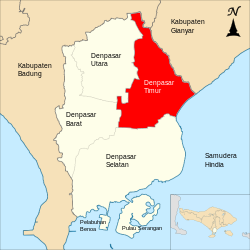
Denpasar Timur, Denpasar

8°38′53″S 115°14′23″E / 8.648024°S 115.239682°E / -8.648024; 115.239682

Denpasar Timur
Peta lokasi Kecamatan Denpasar Timur
Negara Indonesia
ProvinsiBali
KotaDenpasar
Pemerintahan
 • CamatWayan Herman, S.Sos., M.Si.[1]
Populasi
 • Total151,200 jiwa (2.015)[2]
138,404 jiwa (2.010)[3] jiwa
Kode Kemendagri51.71.02 Edit nilai pada Wikidata
Kode BPS5171020 Edit nilai pada Wikidata
Luas21,96 km²[2]
Desa/kelurahan7 Desa
4 Kelurahan[2]
Situs webdentim.denpasarkota.go.id


Denpasar Timur adalah sebuah kecamatan di kota Denpasar, Provinsi Bali, Indonesia.[4]

Sejarah

Masa Kerajaan (1850-1945)

Pada masa kerajaan, sekitar abad ke 18 atau tahun 1850 daerah ini bernama distrik Kesiman yang berkedudukan di Benculuk, Tegehkuri, kelurahan Tonja, yang dipimpin seorang punggawa bernama Jero Gede Rai dari Singaraja. Sekitar tahun 1920, Kantor Distrik Kesiman pindah tempat ke Jaba, sebelah barat Puri Kesiman, yang sebelumnya adalah Wantilan milik Puri Kesiman dengan urutan Pejabat Punggawanya sebagai berikut:

  1. I Gusti Ngurah Gde Kesiman, menjabat tahun 1921 – bulan Mei 1954
  2. I Gusti Ngurah Anom Pacung, menjabat tahun 1954 – 12 Desember 1960
  3. I Gusti ketut Redung, menjabat tahun 1960–1963
  4. I Gusti Kompyang Rogig Sugriwa, menjabat tahun 1963–1965
  5. I Gusti Gde Ngurah, menjabat tahun 1965–1970

Masa Kecamatan Kesiman

Kira-kira tahun 1970 terjadi perubahan nama Distrik Kesiman menjadi Kecamatan Kesiman, dengan pejabatnya adalah:

  1. I Gusti Ketut Anom,BA, menjabat tahun 1970 – 10 Agustus 1974
  2. Drs. Ida Bagus Yudara Pidada, menjabat tahun 1974 – 10 Juli 1978

Kecamatan Kesiman waktu itu mempunyai wilayah Desa sebagai berikut:

  1. Desa Kesiman
  2. Desa Tonja
  3. Desa Penatih
  4. Desa Sumerta
  5. Desa Sanur
  6. Desa Renon
  7. Desa Sesetan
  8. Desa Panjer
  9. Desa Serangan
  10. Desa Ubung
  11. Desa Peguyangan

Pemekaran Kecamatan

Pada tahun 1978 terjadi pemekaran kecamatan dari 2 kecamatan, Kecamatan Denpasar dan Kecamatan Kesiman dimekarkan menjadi 3 kecamatan yaitu:

  1. Kecamatan Denpasar Barat
  2. Kecamatan Denpasar Timur
  3. Kecamatan Denpasar Selatan

Setelah adanya pemekaran Kecamatan dari 2 menjadi 3 Kecamatan dan pemekaran Desa serta perubahan status Desa menjadi Kelurahan, maka wilayah Kecamatan Denpasar Timur dibagi sebagai berikut:

  1. Kelurahan Kesiman
  2. Kelurahan Sumerta
  3. Kelurahan Tonja
  4. Kelurahan Penatih
  5. Kelurahan dangin Puri
  6. Desa Kesiman Pentilan
  7. Desa Kesiman Kertalangu
  8. Desa Penatih Dangin Puri
  9. Desa Sumerta Kaja
  10. Desa Sumerta Kauh
  11. Desa Sumerta Kelod
  12. Desa Dangin Puri Kaja
  13. Desa Dangin Puri Kauh
  14. Desa Dangin Puri Kangin
  15. Desa Dangin Puri Kelod

Pembentukan Kecamatan Denpasar Utara

Setelah dibentuknya Kecamatan Denpasar Utara tahun 2011 di Kota Denpasar, maka wilayah Kecamatan Denpasar Timur terdiri dari 7 Desa dan 4 Kelurahan yaitu:

  1. Kelurahan Dangin Puri
  2. Kelurahan Sumerta
  3. Kelurahan Kesiman
  4. Kelurahan penatih
  5. Desa Penatih Dangri
  6. Desa Dangin Puri Kelod
  7. Desa Sumerta Kelod
  8. Desa Sumerta Kauh
  9. Desa Sumerta Kaja
  10. Desa Kesiman Kertalangu
  11. Desa Kesiman Petilan

Geografi

Kecamatan Denpasar Timur terletak dibagian Timur Kota Denpasar dengan batas-batas:

Ditinjau dari segi Topografi keadaan geografis Kecamatan Denpasar Timur secara umum miring kearah selatan dengan ketinggian berkisar antara 0 – 75 meter dari permukaan laut.

Memiliki morfologi landai dengan kemiringan lahan sebagain besar berkisar 0,5% namun dibagian tepi kemiringan bisa mencapai 15 %.

Iklim

Kecamatan Denpasar Timur termasuk daerah beriklim tropis yang dipengaruhi angin musim sehingga musim kemarau dengan angin timur (Juni-Desember) dan musim hujan dengan angin barat (September – Maret) dan diselingi oleh musim pancaroba. Suhu rata-rata berkisar antara 24.4 – 31.4̊C dengan suhu maksimum pada bulan Januari, sedangkan suhu minimum pada bulan Agustus.

Jumlah curah hujan di Kecamatan Denpasar Timur berkisar 0–406 mm dan rata-rata 97,1 mm. Bulan basah (curah hujan lebih dari 100 mm/bl) selama empat bulan dari bulan Nopember sampai dengan Februari. Sedangkan bulan kering (curah hujan kurang dari 100 mm/bl) selama 8 bulan jatuh pada bulan Maret sampai dengan Oktober. Curah hujan tertinggi terjadi pada bulan Februari (406 mm) dan terendah terjadi bulan Oktober (0 mm).

Luas Wilayah

Kecamatan Denpasar Timur memiliki luas wilayah 22,32 Km² atau 2.232 Ha, terletak disebelah timur Kota Denpasar yang terdiri dari 7 Desa dan 4 Kelurahan serta 54 Dusun, 33 Lingkunngan. Diantara keempat kecamatan di Kota Denpasar luas Kecamatan Denpasar merupakan yang terkecil. Penggunaan tanah terbesar adalah untuk lahan pekarangan yaitu sebesar 1.251 Ha, selanjutnya luas sawah 693 Ha, tegalan 144 Ha, dan lainnya 143 ha. Adapun luas masing-masing Desa/Kelurahan di Kecamatan Denpasar Timur adalah sebagai berikut:

Luas Wilayah Kecamatan Denpasar Timur Tahun 2013:

No. Desa/Kelurahan Luas Wilayah

(km²)

1. Desa Dangin Puri Klod 2,23
2. Desa Sumerta Klod 2,68
3. Desa Kesiman Petilan 2,84
4. Desa Kesiman Kertalangu 3,76
5. Desa Sumerta Kaja 0,52
6. Desa Sumerta Kauh 0,89
7. Desa Penatih Dangin Puri 3,12
8. Kelurahan Kesiman 2,43
9. Kelurahan Sumerta 0,50
10. Kelurahan Penatih 2,73
11. Kelurahan Dangin Puri 0,62
Kecamatan Denpasar Timur 22,31

Sumber: Denpasar Timur Dalam Angka Tahun 2014.

Pemerintahan

Pembagian administratif

Kecamatan Denpasar Timur terdiri dari 7 Desa dan 4 Kelurahan sebagai berikut:

Daftar camat Denpasar Timur

Adapun Nama Pejabat Kecamatan Denpasar Timur mulai tanggal 11 Juli 1978 adalah sebagai berikut:

No. Nama Camat Awal Jabatan Akhir Jabatan Ket.
1 I Gusti Ketut Rai Surabela,BA, 11 Juli 1978 17 Juni 1983
2 Drs. I wayan Sudiarta 18 Juni 1983 11 September 1987
3 Drs. I Nengah Metra 12 September 1987 12 November 1990
4 Dra. Ni Wayan Sudri 13 November 1990 4 Januari 1994
5 Drs. Ida Bagus Md Suthapa 5 Januari 1994 26 Januari 1999
6 Drs. Ida Bagus Md Brahmaputra 27 Januari 1999 14 Juni 2000
7 Drs. I G.A. Rai Anom Suradi 15 Juni 2000 2006
8 Drs I Ketut Dunia 2006 2010
9 I.B. Alit S.pd 2010 2012
10 I Dewa Made Puspawan, S.IP,MM 2014 2019
11 Wayan Herman, S.Sos., M.Si 2019 2019 - Sekarang

Demografi

Jumlah Penduduk Kecamatan Denpasar Timur sampai bulan Desember 2013 sesuai dengan data dari Badan Pusat Statistik Kota Denpasar adalah 146.510 jiwa, laki-laki sebanyak 74.460 jiwa dan perempuan sebanyak 146.510 jiwa. Kepadatan penduduk Kecamatan Denpasar Timur adalah 6.567 jiwa/km².[2]

Sebaran penduduk Kecamatan Denpasar Timur dapat dilihat pada table berikut:

No. Desa/Kelurahan Laki-Laki Perempuan Jumlah
1. Dangin Puri Klod 8.557 8.002 16.559
2. Sumerta Klod 10.409 9.854 20.263
3. Kesiman 8.120 7.710 15.830
4. Kesiman Petilan 6.224 5.960 12.184
5. Kesiman Kertalangu 14.081 13.351 27.433
6. Sumerta 5.354 5.477 10.830
7. Sumerta Kaja 4.420 4.420 8.840
8. Sumerta Kauh 4.102 4.067 8.169
9. Dangin Puri 3.606 3.647 7.253
10. Penatih 5.911 5.940 11.851
11. Penatih Dangin Puri 3.677 3.621 7.298
Kecamatan Denpasar Timur 74.460 72.050 146.510
Sumber
Denpasar Timur Dalam Angkat Tahun 2014

Referensi

  1. ^ "Profil Kecamatan Denpasar Timur". dentim.denpasarkota.go.id. Diakses tanggal 2020-06-27. 
  2. ^ a b c d "Kecamatan Denpasar Timur Dalam Angka 2017". Badan Pusat Statistik Indonesia. 2017. Diakses tanggal 16-12-2018. 
  3. ^ "Penduduk Indonesia Menurut Desa 2010" (PDF). Badan Pusat Statistik. 2010. hlm. 132. Diakses tanggal 14 Juni 2019. 
  4. ^ "Peraturan Menteri Dalam Negeri Nomor 137 Tahun 2017 tentang Kode dan Data Wilayah Administrasi Pemerintahan". Kementerian Dalam Negeri Republik Indonesia. Diarsipkan dari versi asli tanggal 29 Desember 2018. Diakses tanggal 3 Oktober 2019. 

Pranala luar

Read other articles:

Fictional character appearing in Marvel Comics This article has multiple issues. Please help improve it or discuss these issues on the talk page. (Learn how and when to remove these template messages) The topic of this article may not meet Wikipedia's general notability guideline. Please help to demonstrate the notability of the topic by citing reliable secondary sources that are independent of the topic and provide significant coverage of it beyond a mere trivial mention. If notability cannot b…

周處除三害The Pig, The Snake and The Pigeon正式版海報基本资料导演黃精甫监制李烈黃江豐動作指導洪昰顥编剧黃精甫主演阮經天袁富華陳以文王淨李李仁謝瓊煖配乐盧律銘林孝親林思妤保卜摄影王金城剪辑黃精甫林雍益制片商一種態度電影股份有限公司片长134分鐘产地 臺灣语言國語粵語台語上映及发行上映日期 2023年10月6日 (2023-10-06)(台灣) 2023年11月2日 (2023-11-02)(香港、…

National hero Sattar KhanBornOctober 20, 1866Sardar Kandy, IranDiedNovember 17, 1914 (aged 48)Tehran, IranBurial placeShah-Abdol-Azim shrinePolitical partyModerate Socialists Party[1]SpouseFatemehChildrenYadollah, Soltan, Masoumeh, Jalil Sattar Khan (Persian: ستارخان, IPA: [sættːɒːɾ xɒn], October 20, 1866 – November 17, 1914), honorarily titled Sardār-e Melli (Persian: سردار ملی meaning National Commander) was a pivotal figure in the Iranian Constitutional…

Îles du Prince-de-MonacoGeografia fisicaLocalizzazioneOceano Indiano Coordinate49°37′00″S 69°14′00″E / 49.616667°S 69.233333°E-49.616667; 69.233333Coordinate: 49°37′00″S 69°14′00″E / 49.616667°S 69.233333°E-49.616667; 69.233333 ArcipelagoIsole Kerguelen Geografia politicaStato Francia Territorio d'oltremare Terre australi e antartiche francesi DistrettoIsole Kerguelen CartografiaÎles du Prince-de-Monaco voci di isole della Francia pr…

La Rioja Comunidad autónomaBanderaEscudo Himno: Himno de La Rioja Ubicación de La Rioja en España Mapa interactivoCoordenadas 42°15′N 2°30′O / 42.25, -2.5Capital Logroño[1]​(ciudad más poblada)Idioma oficial EspañolEntidad Comunidad autónoma • País  EspañaParlamentoPresidente Parlamento de La RiojaGonzalo Capellán (PP)Subdivisiones 174 municipios 3 partidos judicialesSuperficie Puesto 16.º • Total 5045 km² (1,0%)Altitud   …

Arrow Air IATA ICAO Kode panggil JW APW BIG A Didirikan1947 (1947)Berhenti beroperasi30 Juni 2010 (2010-06-30)PenghubungBandar Udara Internasional MiamiPerusahaan indukMatlinPattersonKantor pusatMiami-Dade County, Florida, Amerika SerikatTokoh utamaLuis Soto (Presiden)[1]Karyawan1000Situs webwww.arrowair.com Arrow Air adalah maskapai penerbangan kargo dan penumpang yang berbasis di Building 712 di dalam wilayah Bandar Udara Internasional Miami (MIA) di Miami-Dade County, Florid…

يفتقر محتوى هذه المقالة إلى الاستشهاد بمصادر. فضلاً، ساهم في تطوير هذه المقالة من خلال إضافة مصادر موثوق بها. أي معلومات غير موثقة يمكن التشكيك بها وإزالتها. (فبراير 2016) هذه المقالة تحتاج للمزيد من الوصلات للمقالات الأخرى للمساعدة في ترابط مقالات الموسوعة. فضلًا ساعد في تحسي…

本條目存在以下問題,請協助改善本條目或在討論頁針對議題發表看法。 此條目需要編修,以確保文法、用詞、语气、格式、標點等使用恰当。 (2013年8月6日)請按照校對指引,幫助编辑這個條目。(幫助、討論) 此條目剧情、虛構用語或人物介紹过长过细,需清理无关故事主轴的细节、用語和角色介紹。 (2020年10月6日)劇情、用語和人物介紹都只是用於了解故事主軸,輔助讀…

  لمعانٍ أخرى، طالع محمد يونس (توضيح). مقدمة هذه المقالة بحاجة لإعادة كتابة لتتوافق مع المبادئ التوجيهية لكتابة مقدمات المقالات. فضلًا، ساهم في تحسينها بإعادة كتابة المقدمة لتلخص أهم ما جاء فيها بشكل متوافق دليل الأسلوب. (يناير 2019) محمد يونس (بالبنغالية: মুহাম্মদ ইউ…

Concept of eternal life For other uses, see Immortal (disambiguation). Not to be confused with Immorality. This article needs additional citations for verification. Please help improve this article by adding citations to reliable sources. Unsourced material may be challenged and removed.Find sources: Immortality – news · newspapers · books · scholar · JSTOR (June 2015) (Learn how and when to remove this message) The Fountain of Eternal Life in Cleveland, …

Ethnic group of Western New Guinea Ethnic group DaniHubula, Balim, ParimA Dani man with custom accessoriesTotal population90,000[1]Regions with significant populations Indonesia (Highland Papua)LanguagesDani languages, Indonesian languageReligionChristianity (especially Protestant), IslamRelated ethnic groupsHupla people, Lani people, Nduga people, Walak people, Wano people, Yali people The Dani (also spelled Ndani) are an ethnic group from the Central Highlands of Western New Guine…

Catalog of types of postage stamps Cover of the 1868 Scott catalogue covering the first 28 years of stamps; America and Foreign Catalogs from the Michel range First original American stamp catalog A stamp catalog (or stamp catalogue) is a catalog of postage stamp types with descriptions and prices. The stamp catalog is an essential tool of philately and stamp collecting. Stamp catalogs are part of philatelic literature. Similar catalogs of other collectible objects. such as matchboxes (phillumen…

Tateyama Cable Car carriage Along the line This article does not cite any sources. Please help improve this article by adding citations to reliable sources. Unsourced material may be challenged and removed.Find sources: Tateyama Cable Car – news · newspapers · books · scholar · JSTOR (April 2019) (Learn how and when to remove this message)The Tateyama Cable Car (立山ケーブルカー) is a Japanese funicular line of Tateyama Kurobe Kankō (立山黒部…

Institutional corruption in the country Political corruption Forms and concepts Bribery Cronyism Economics of corruption Electoral fraud Elite capture Influence peddling Kleptocracy Mafia state Nepotism Pyrrhic defeat theory Slush fund Simony State capture State-corporate crime Throffer Anti-corruption International Anti-Corruption Court Group of States Against Corruption International Anti-Corruption Academy International Anti-Corruption Day United Nations Convention against Corruption Corrupti…

Christian university in Grayson, Kentucky Kentucky Christian UniversityFormer namesChristian Normal Institute (1919–1944)Kentucky Christian College (1944–2004)TypePrivate universityEstablished1919Religious affiliationChristian churches and churches of ChristPresidentTerry AllcornStudents500[1]LocationGrayson, Kentucky, United States38°20′28″N 82°56′49″W / 38.341°N 82.947°W / 38.341; -82.947Colors   Red & BlackSporting affiliationsNAIA…

2017 SonomaRace details17th round of the 2017 IndyCar Series seasonDateSeptember 17, 2017Official nameGoPro Grand Prix of SonomaLocationSonoma RacewayCoursePermanent racing facility2.2 mi / 3.5 kmDistance85 laps195.755 mi / 315.037 kmPole positionDriverJosef Newgarden (Team Penske)Time1:15.5205PodiumFirstSimon Pagenaud (Team Penske)SecondJosef Newgarden (Team Penske)ThirdWill Power (Team Penske)Motor car race The 2017 GoPro Grand Prix of Sonoma was the 17th and final rou…

Museo del TricoloreBandiera sabauda con corona sec. XIX UbicazioneStato Italia LocalitàReggio Emilia IndirizzoP.zza Casotti, 1 Coordinate44°41′49.67″N 10°37′49.37″E44°41′49.67″N, 10°37′49.37″E CaratteristicheTipoStoria Apertura7 gennaio 2004 Visitatori17 456 (2022) Sito web Modifica dati su Wikidata · Manuale Il Museo del Tricolore è una delle sedi dei Musei Civici di Reggio Emilia, situato all'interno del municipio della città, adiacente alla Sala del Tric…

«Guise» redirige aquí. Para el Almirante Guise, véase Martín Guise. Guisa Entidad subnacional Escudo GuisaLocalización de Guisa en Francia Coordenadas 49°54′01″N 3°37′39″E / 49.900277777778, 3.6275Entidad Comuna de Francia • País  Francia • Región Alta Francia • Departamento Aisne • Distrito Vervins • Cantón Guisa (bureau centralisateur) • Mancomunidad Thiérache Sambre et Oise (sede)Alcalde Hugues Cochet (2014-202…

Volkerak highlighted in cyan. The Volkerak is a body of water in the Netherlands. It is part of the Rhine–Meuse–Scheldt delta, and is situated between the island Goeree-Overflakkee to the north-west and the Dutch mainland to the south and east. The western part of the Volkerak is also called Krammer. Tributaries of the Volkerak are the Dintel and Steenbergse Vliet. Before 1987, it was a tidal river open to the North Sea, but it was closed off as part of the Delta Works; it is now a fresh wat…

1974–75 Australian bushfire seasonThe area burnt in the inland fires of 1974-1975[1]Date(s)October 1974 – February 1975LocationNew South WalesNorthern TerritoryQueenslandSouth AustraliaWestern AustraliavictoriaStatisticsTotal area117 million hectares (290 million acres)ImpactsDeaths6Livestock losses57,000Structures destroyed10,200 kilometres (6,300 mi) of fencing← Previous season Next season → The 1974–75 Australian bushfire season is a ser…