|
Maseru
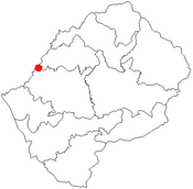
 Peta lokasi Maseru Peta lokasi Maseru
Maseru adalah ibu kota, sekaligus kota terbesar Lesotho. Penduduknya berjumlah 194.000 jiwa (2004).
Geografi
Iklim
| Data iklim Maseru, Lesotho
|
| Bulan
|
Jan
|
Feb
|
Mar
|
Apr
|
Mei
|
Jun
|
Jul
|
Agt
|
Sep
|
Okt
|
Nov
|
Des
|
Tahun
|
| Rata-rata tertinggi °C (°F)
|
30
(86)
|
28
(82)
|
26
(79)
|
23
(73)
|
19
(66)
|
17
(63)
|
17
(63)
|
19
(66)
|
22
(72)
|
25
(77)
|
27
(81)
|
29
(84)
|
23.5
(74.3)
|
| Rata-rata terendah °C (°F)
|
17
(63)
|
17
(63)
|
14
(57)
|
10
(50)
|
4
(39)
|
1
(34)
|
0
(32)
|
3
(37)
|
8
(46)
|
11
(52)
|
13
(55)
|
16
(61)
|
9.5
(49.1)
|
| Sumber: My Forecast.Com[1]
|
Referensi
Pranala luar
Wikimedia Commons memiliki media mengenai Maseru.
|
|---|
| Afrika Timur |
- Addis Ababa, Etiopia
- Antananarivo, Madagaskar
- Asmara, Eritrea
- Jibouti, Jibuti
- Dodoma, Tanzania
- Gitega, Burundi
- Kampala, Uganda
- Kigali, Rwanda
- Lilongwe, Malawi
- Lusaka, Zambia
- Mamoudzou, Mayotte
- Maputo, Mozambik
- Mogadishu, Somalia
- Moroni, Komoro
- Nairobi, Kenya
- Port Louis, Mauritius
- Saint-Denis, Réunion
- Victoria, Seychelles
|
|---|
| Afrika Tengah | |
|---|
| Afrika Utara | |
|---|
| Afrika Selatan | |
|---|
| Afrika Barat |
- Abidjan, Pantai Gading 4
- Abuja, Nigeria
- Accra, Ghana
- Bamako, Mali
- Banjul, Gambia
- Bissau, Guinea-Bissau
- Conakry, Guinea
- Dakar, Senegal
- Freetown, Sierra Leone
- Jamestown, Saint Helena
- Lomé, Togo
- Monrovia, Liberia
- Niamey, Niger
- Nouakchott, Mauritania
- Ouagadougou, Burkina Faso
- Porto-Novo, Benin
- Praia, Tanjung Verde
- Yamoussoukro, Pantai Gading 5
|
|---|
1 Yudisial. 2 Parlementer. 3 Eksekutif. 4 de facto. 5 Resmi. |
|
|


