Ostprignitz-Ruppin

Ostprignitz-Ruppin
Flag of Ostprignitz-Ruppin
Coat of arms of Ostprignitz-Ruppin
Map
CountryGermany
StateBrandenburg
CapitalNeuruppin
Government
 • District admin.Ralf Reinhardt (SPD)
Area
 • Total
2,508.7 km2 (968.6 sq mi)
Population
 (31 December 2022)[1]
 • Total
99,871
 • Density40/km2 (100/sq mi)
Time zoneUTC+01:00 (CET)
 • Summer (DST)UTC+02:00 (CEST)
Vehicle registrationOPR, KY, NP, WK
Websiteostprignitz-ruppin.de

Ostprignitz-Ruppin is a Kreis (district) in the northwestern part of Brandenburg, Germany. Neighboring are (from north clockwise) the districts Müritz and Mecklenburg-Strelitz in Mecklenburg-Western Pomerania, the districts Oberhavel and Havelland, the district Stendal in Saxony-Anhalt, and the district Prignitz.

Geography

The district consists of plain countryside northwest of Berlin. It is densely forested. Many rivers and lakes can be found in its western, its central and its northeastern part. The main river in the district is the Dosse.

History

The district has always been distinguishable from the West Prignitz, having been settled originally by Slavs from a different part of Mecklenburg. It was officially created in 1993 by merging the districts Kyritz, Neuruppin and Wittstock. The district roughly covers the same territory as the two historic districts Ostprignitz and Ruppin. Osprignitz was created in 1815 as one of two districts covering the former county Prignitz, and was split into the districts Kyritz, Pritzwalk and Wittstock in 1952. Also in 1952 the district Ruppin was renamed to Neuruppin and had to give part of its territory to the districts Kyritz and Gransee.

Demography

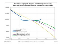
Landkreis Ostprignitz-Ruppin: Population development
within the current boundaries (2017)[2]
YearPop.±% p.a.
1875 101,605—    
1890 102,153+0.04%
1910 102,634+0.02%
1925 106,311+0.23%
1933 109,576+0.38%
1939 114,606+0.75%
1946 157,875+4.68%
1950 153,496−0.70%
1964 124,190−1.50%
1971 123,486−0.08%
1981 119,269−0.35%
1985 120,184+0.19%
1989 120,271+0.02%
1990 118,794−1.23%
1991 116,002−2.35%
YearPop.±% p.a.
1992 117,102+0.95%
1993 116,866−0.20%
1994 116,180−0.59%
1995 116,005−0.15%
1996 115,637−0.32%
1997 115,670+0.03%
1998 115,193−0.41%
1999 114,273−0.80%
2000 112,930−1.18%
2001 111,878−0.93%
2002 111,009−0.78%
2003 110,057−0.86%
2004 108,893−1.06%
2005 108,027−0.80%
2006 106,830−1.11%
YearPop.±% p.a.
2007 105,812−0.95%
2008 104,786−0.97%
2009 103,734−1.00%
2010 102,868−0.83%
2011 99,753−3.03%
2012 99,125−0.63%
2013 98,944−0.18%
2014 98,886−0.06%
2015 99,110+0.23%
2016 99,414+0.31%
2017 99,368−0.05%
2018 99,078−0.29%
2019 98,861−0.22%

Coat of arms

The eagle in the top of the coat of arms derives from the Counts of Arnstein, who ruled Ruppin in the 13th century. To the left is a fleur-de-lis representing the Counts von Plotho, a Wendish family who ruled Kyritz, where they had migrated from the Magdeburg area bringing German families such as the von Blumenthals with them. The mitre to the right symbolizes Wittstock, as Bishop Heinrich I made Wittstock the capital of the Prince-Bishopric of Havelberg.

Towns and municipalities

WittstockHeiligengrabeRheinsbergNeuruppinLindowVielitzseeHerzbergRüthnickFehrbellinKyritzBreddinStüdenitz-SchönermarkZernitz-LohmNeustadt (Dosse)Sieversdorf-HohenofenDreetzWalslebenDabergotzStorbeck-FrankendorfTemnitzquellTemnitztalMärkisch LindenWusterhausenSaxony-AnhaltMecklenburg-VorpommernMecklenburg-VorpommernMecklenburg-VorpommernMecklenburg-Vorpommern
Clickable map of towns and municipalities in the district
Amt-free towns Ämter
  1. Kyritz
  2. Neuruppin
  3. Rheinsberg
  4. Wittstock


Amt-free municipalities

  1. Fehrbellin
  2. Heiligengrabe
  3. Wusterhausen

1. Lindow (Mark)

  1. Herzberg
  2. Lindow1, 2
  3. Rüthnick
  4. Vielitzsee

2. Neustadt (Dosse)

  1. Breddin
  2. Dreetz
  3. Neustadt an der Dosse1, 2
  4. Sieversdorf-Hohenofen
  5. Stüdenitz-Schönermark
  6. Zernitz-Lohm

3. Temnitz

  1. Dabergotz
  2. Märkisch Linden
  3. Storbeck-Frankendorf
  4. Temnitzquell
  5. Temnitztal
  6. Walsleben1
1seat of the Amt; ²town

References

  1. ^ "Bevölkerungsentwicklung und Bevölkerungsstandim Land Brandenburg Dezember 2022" (PDF). Amt für Statistik Berlin-Brandenburg (in German). June 2023.
  2. ^ Detailed data sources are to be found in the Wikimedia Commons.Population Projection Brandenburg at Wikimedia Commons.

Media related to Ostprignitz-Ruppin at Wikimedia Commons

52°58′N 12°40′E / 52.967°N 12.667°E / 52.967; 12.667


Prefix: a b c d e f g h i j k l m n o p q r s t u v w x y z 0 1 2 3 4 5 6 7 8 9

Portal di Ensiklopedia Dunia