Herzberg, Ostprignitz-Ruppin

Herzberg
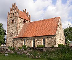
Church
Church
Location of Herzberg within Ostprignitz-Ruppin district
WittstockHeiligengrabeRheinsbergNeuruppinLindowVielitzseeHerzbergRüthnickFehrbellinKyritzBreddinStüdenitz-SchönermarkZernitz-LohmNeustadt (Dosse)Sieversdorf-HohenofenDreetzWalslebenDabergotzStorbeck-FrankendorfTemnitzquellTemnitztalMärkisch LindenWusterhausenSaxony-AnhaltMecklenburg-VorpommernMecklenburg-VorpommernMecklenburg-VorpommernMecklenburg-Vorpommern
Herzberg is located in Germany
Herzberg
Herzberg
Herzberg is located in Brandenburg
Herzberg
Herzberg
Coordinates: 52°54′N 12°59′E / 52.900°N 12.983°E / 52.900; 12.983
CountryGermany
StateBrandenburg
DistrictOstprignitz-Ruppin
Municipal assoc.Lindow (Mark)
Government
 • Mayor (2024–29) Michaela Wolff[1]
Area
 • Total
18.57 km2 (7.17 sq mi)
Elevation
46 m (151 ft)
Population
 (2022-12-31)[2]
 • Total
673
 • Density36/km2 (94/sq mi)
Time zoneUTC+01:00 (CET)
 • Summer (DST)UTC+02:00 (CEST)
Postal codes
16835
Dialling codes033926
Vehicle registrationOPR

Herzberg (German pronunciation: [ˈhɛʁt͡sˌbɛʁk] ) is a municipality in the Ostprignitz-Ruppin district, in Brandenburg, Germany.

Alcove house

History

From 1815 to 1945, Herzberg was part of the Prussian Province of Brandenburg. From 1952 to 1990, it was part of the Bezirk Potsdam of East Germany.

Demography

Development of population since 1875 within the current boundaries (Blue line: Population; Dotted line: Comparison to population development of Brandenburg state; Grey background: Time of Nazi rule; Red background: Time of communist rule)
Herzberg (Mark): Population development
within the current boundaries (2013)[3]
YearPop.±% p.a.
1875 869—    
1890 795−0.59%
1910 768−0.17%
1925 728−0.36%
1933 767+0.65%
1939 843+1.59%
1946 1,275+6.09%
1950 1,266−0.18%
1964 874−2.61%
1971 855−0.31%
1981 738−1.46%
1985 729−0.31%
1989 716−0.45%
1990 700−2.23%
1991 668−4.57%
1992 673+0.75%
1993 659−2.08%
1994 642−2.58%
1995 643+0.16%
1996 624−2.95%
YearPop.±% p.a.
1997 640+2.56%
1998 681+6.41%
1999 683+0.29%
2000 699+2.34%
2001 698−0.14%
2002 716+2.58%
2003 721+0.70%
2004 703−2.50%
2005 708+0.71%
2006 667−5.79%
2007 671+0.60%
2008 669−0.30%
2009 672+0.45%
2010 660−1.79%
2011 643−2.58%
2012 634−1.40%
2013 638+0.63%
2014 617−3.29%
2015 630+2.11%
2016 659+4.60%

References

  1. ^ Landkreis Ostprignitz-Ruppin Wahl der Bürgermeisterin / des Bürgermeisters. Retrieved 10 July 2024.
  2. ^ "Bevölkerungsentwicklung und Bevölkerungsstandim Land Brandenburg Dezember 2022" (PDF). Amt für Statistik Berlin-Brandenburg (in German). June 2023.
  3. ^ Detailed data sources are to be found in the Wikimedia Commons.Population Projection Brandenburg at Wikimedia Commons