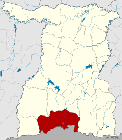
Kap Choeng district

Kap Choeng
กาบเชิง
District location in Surin province
Coordinates: 14°28′29″N 103°35′39″E / 14.47472°N 103.59417°E / 14.47472; 103.59417
CountryThailand
ProvinceSurin
SeatKap Choeng
Area
 • Total
574.0 km2 (221.6 sq mi)
Population
 (2005)
 • Total
59,589
 • Density103.8/km2 (269/sq mi)
Time zoneUTC+7 (ICT)
Postal code32210
Geocode3206

Kap Choeng (Thai: กาบเชิง, pronounced [kàːp t͡ɕʰɤ̄ːŋ]) is a district (amphoe) in the southern part of Surin province, northeastern Thailand.

History

The village of Ban Kap Choeng is about 200 years old. It was originally under sub-district (tambon) Dan of Sangkha district, but 1937 was moved to Tambon Nong Yai, Prasat district. In 1964, it became part of the newly created sub-district of Kap Choeng.[1]

On 25 May 1975, Tambon Kap Choeng and Bakdai were combined to form a minor district (king amphoe).[2] Tambon Khok Klang was created in 1976,[3] Tambons Dan and Khu Tan were transferred to it from Sangkha in 1977.[4] On 20 March 1979, Kap Choeng was upgraded to a full district.[5]

Geography

Neighboring districts are (from the west clockwise): Phanom Dong Rak, Prasat and Sangkha of Surin Province. To the south is Oddar Meancheay of Cambodia.

The southern part of this district is in the Dângrêk Mountains. An international border crossing into Cambodia is called the Chong Chom Checkpoint which is located in Dan village in the southern part of this district. The checkpoint on the Cambodian side is called O Smach International Checkpoint in Samraong Municipality, Oddar Meanchey province.

Administration

The district is divided into six sub-districts (tambons), which are further subdivided into 91 villages (mubans). There are no municipal (thesaban) areas. There are six tambon administrative organizations (TAO).

No. Name Thai name Villages Pop.
1. Kap Choeng กาบเชิง 19 14,123
4. Khu Tan คูตัน 14 5,601
5. Dan ด่าน 17 12,729
6. Naeng Mut แนงมุด 15 10,594
7. Khok Takhian โคกตะเคียน 13 11,435
10. Takhian ตะเคียน 13 5,107

Missing numbers are tambons which now form Phanom Dong Rak District.

References

  1. ^ ประกาศกระทรวงมหาดไทย เรื่อง ตั้งและเปลี่ยนแปลงเขตตำบลในท้องที่อำเภอปราสาท จังหวัดสุรินทร์ (PDF). Royal Gazette (in Thai). 81 (18 ง): 346–348. 1964-02-18. Archived from the original (PDF) on May 28, 2012.
  2. ^ ประกาศกระทรวงมหาดไทย เรื่อง แบ่งท้องที่อำเภอปราสาท จังหวัดสุรินทร์ ตั้งเป็นกิ่งอำเภอกาบเชิง (PDF). Royal Gazette (in Thai). 92 (98 ง): 2518. May 10, 1975. Archived from the original (PDF) on January 27, 2012.
  3. ^ ประกาศกระทรวงมหาดไทย เรื่อง ตั้งและเปลี่ยนแปลงเขตตำบลในท้องที่กิ่งอำเภอกาบเชิง อำเภอปราสาท จังหวัดสุรินทร์ (PDF). Royal Gazette (in Thai). 93 (108 ง): 2342. 1976-09-07. Archived from the original (PDF) on January 27, 2012.
  4. ^ พระราชกฤษฎีกาเปลี่ยนแปลงเขตอำเภอสังขะกับกิ่งอำเภอกาบเชิง อำเภอปราสาท จังหวัดสุรินทร์ พ.ศ. ๒๕๒๐ (PDF). Royal Gazette (in Thai). 94 (65 ก ฉบับพิเศษ): 11–13. 1977-07-14. Archived from the original (PDF) on January 27, 2012.
  5. ^ พระราชกฤษฎีกาตั้งอำเภอหนองกุงศรี อำเภอไทรงาม อำเภอบ้านฝาง อำเภออุบลรัตน์ อำเภอเวียงชัย อำเภอดอยเต่า อำเภอนิคมคำสร้อย อำเภอนาหว้า อำเภอเสิงสาง อำเภอศรีสาคร อำเภอบึงสามพัน อำเภอนาดูน อำเภอค้อวัง อำเภอโพธิ์ชัย อำเภอเมืองสรวง อำเภอปลวกแดง อำเภอยางชุมน้อย อำเภอกาบเชิง อำเภอสุวรรณคูหา และอำเภอกุดข้าวปุ้น พ.ศ. ๒๕๒๒ (PDF). Royal Gazette (in Thai). 96 (42 ก Special): 19–24. March 25, 1979. Archived from the original (PDF) on September 30, 2007.


Prefix: a b c d e f g h i j k l m n o p q r s t u v w x y z 0 1 2 3 4 5 6 7 8 9

Portal di Ensiklopedia Dunia