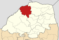
Blouberg Local Municipality

Blouberg
Official seal of Blouberg
Location in Limpopo
Location in Limpopo
CountrySouth Africa
ProvinceLimpopo
DistrictCapricorn
SeatSenwabarwana
Wards22
Government
 • TypeMunicipal council
 • MayorMaseka Solomon Pheedi
Area
 • Total
9,248 km2 (3,571 sq mi)
Population
 (2011)[2]
 • Total
162,629
 • Density18/km2 (46/sq mi)
Racial makeup (2011)
 • Black African99.0%
 • Coloured0.0%
 • Indian/Asian0.1%
 • White0.6%
First languages (2011)
 • Northern Sotho93.8%
 • Other6.2%
Time zoneUTC+2 (SAST)
Municipal codeLIM351

Blouberg Municipality (Northern Sotho: Mmasepala wa Blouberg) is a local municipality within the Capricorn District Municipality, in the Limpopo province of South Africa, bordering Botswana. It takes its name from the Blouberg (literally meaning "blue mountain" in Afrikaans),[3] a mountain range located to the west of the western end of the Soutpansberg mountain range, north west of the town of Vivo. Blouberg is home to some of the most spectacular rock climbing in South Africa. The rock climbing destination is famous for its big wall natural climbing with route lengths up to 350m. The vegetation ranges from sub-tropical savanna at the base, to alpine near the summit.

Demography

According to the 2001 census conducted by Statistics South Africa, the population of the greater Blouberg municipality was 161,314, of whom 99.4% are African, 0.5% white, 0.1% Coloured and 0.1% Asian.

A boy in Blouberg amongst some dwellings
Men playing "pool" (snooker) in a bar in Blouberg, Limpopo.

Main places

The 2001 census divided the municipality into the following main places:[4]

Place Code Area (km2) Population Most spoken language
Alldays 90901 11.75 385 Northern Sotho
Bahanawa 90902 390.17 19,068 Northern Sotho
Bahanawa-Ba-Kibi 90903 163.78 7,763 Northern Sotho
Bochum Part 1 90912 4.33 8,501 Northern Sotho
Bochum Part 2 90905 182.33 15,911 Northern Sotho
Dichoeng 90906 58.29 17,347 Northern Sotho
Ga-Manthata 90907 1,335.47 72,175 Northern Sotho
Ga-Matlala 90908 180.83 8,697 Northern Sotho
Ga-Ramutla 90910 7.81 1,047 Northern Sotho
Remainder of the municipality 90904 2,198.72 5,539 Northern Sotho

Politics

The municipal council consists of forty-four members elected by mixed-member proportional representation. Twenty-two councillors are elected by first-past-the-post voting in twenty-two wards, while the remaining twenty-two are chosen from party lists so that the total number of party representatives is proportional to the number of votes received. In the election of 1 November 2021 the African National Congress (ANC) won a majority of thirty-three seats on the council. The following table shows the results of the election.[5]

PartyWardListTotal
seats
Votes%SeatsVotes%Seats
African National Congress26,23071.542226,88774.421133
Economic Freedom Fighters5,67915.4905,87816.2777
Congress of the People1,2203.3301,1173.0922
Democratic Alliance9452.5809562.6511
Independent candidates1,4573.9700
Abantu Batho Congress3620.9903220.8911
11 other parties7702.1009712.6900
Total36,663100.002236,131100.002244
Valid votes36,66398.5636,13197.96
Invalid/blank votes5371.447542.04
Total votes37,200100.0036,885100.00
Registered voters/turnout82,93544.8582,93544.47

References

  1. ^ "Contact list: Executive Mayors". Government Communication & Information System. Archived from the original on 14 July 2010. Retrieved 22 February 2012.
  2. ^ a b c "Statistics by place". Statistics South Africa. Retrieved 27 September 2015.
  3. ^ "Seraki Blouberg Route - South Africa - Open Africa". Archived from the original on 5 January 2012. Retrieved 22 March 2012.
  4. ^ Lookup Tables - Statistics South Africa[permanent dead link]
  5. ^ "Election Result Table for LGE2021 — Blouberg". wikitable.frith.dev. Retrieved 26 January 2023.

23°08′21″S 29°00′05″E / 23.1392°S 29.0013°E / -23.1392; 29.0013