莫伯利 (密蘇里州)

莫伯利
Moberly
城市
莫伯利的天際線
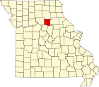
莫伯利在蘭道夫縣及密蘇里州的位置(以紅色標示)
莫伯利在密蘇里州的位置
莫伯利
莫伯利
莫伯利在密蘇里州的位置
坐标:39°25′04″N 92°26′11″W / 39.41778°N 92.43639°W / 39.41778; -92.43639
國家美国
州份密蘇里州
蘭道夫縣
面积
 • 总计34.24 平方公里(13.22 平方英里)
 • 陸地34.13 平方公里(13.18 平方英里)
 • 水域0.11 平方公里(0.04 平方英里)
海拔266 公尺(873 英尺)
人口2020[1]
 • 總計13,783人
 • 密度403人/平方公里(1,043人/平方英里)
时区CSTUTC-6
 • 夏时制CDT(UTC-5
郵區編號65270
電話區號573英语Area code 573
GNIS ID2395362[2]

莫伯利(英語:Moberly)是位於美國密蘇里州蘭道夫縣城市

氣候

莫伯利 (密蘇里州),1991–2020年正常值,1936年至今極端數據
月份 1月 2月 3月 4月 5月 6月 7月 8月 9月 10月 11月 12月 全年
历史最高温 °F(°C) 76
(24)
82
(28)
87
(31)
92
(33)
96
(36)
102
(39)
112
(44)
108
(42)
102
(39)
96
(36)
83
(28)
73
(23)
112
(44)
平均高温 °F(°C) 37.1
(2.8)
42.2
(5.7)
53.9
(12.2)
64.7
(18.2)
74.2
(23.4)
82.8
(28.2)
87.0
(30.6)
85.6
(29.8)
78.2
(25.7)
66.8
(19.3)
53.2
(11.8)
42.0
(5.6)
64.0
(17.8)
日均气温 °F(°C) 28.0
(−2.2)
32.5
(0.3)
43.8
(6.6)
54.4
(12.4)
64.5
(18.1)
73.2
(22.9)
77.3
(25.2)
75.7
(24.3)
67.8
(19.9)
56.3
(13.5)
43.5
(6.4)
33.3
(0.7)
54.2
(12.3)
平均低温 °F(°C) 18.9
(−7.3)
22.7
(−5.2)
33.6
(0.9)
44.1
(6.7)
54.9
(12.7)
63.7
(17.6)
67.5
(19.7)
65.7
(18.7)
57.3
(14.1)
45.9
(7.7)
33.8
(1.0)
24.7
(−4.1)
44.4
(6.9)
历史最低温 °F(°C) −21
(−29)
−19
(−28)
−12
(−24)
17
(−8)
28
(−2)
40
(4)
48
(9)
44
(7)
32
(0)
18
(−8)
−4
(−20)
−20
(−29)
−21
(−29)
平均降水量 英寸(mm) 1.87
(47)
2.06
(52)
3.26
(83)
4.58
(116)
5.13
(130)
5.16
(131)
4.53
(115)
3.94
(100)
3.95
(100)
3.38
(86)
2.65
(67)
2.19
(56)
42.70
(1,085)
平均降雪量 英寸(cm) 5.6
(14)
3.2
(8.1)
1.2
(3.0)
0.2
(0.51)
0.0
(0.0)
0.0
(0.0)
0.0
(0.0)
0.0
(0.0)
0.0
(0.0)
0.1
(0.25)
0.7
(1.8)
4.0
(10)
15.1
(38)
平均降水天数(≥ 0.01 in) 6.4 6.8 9.2 10.9 12.1 9.6 7.9 7.8 7.4 8.7 7.3 7.0 101.1
平均降雪天数(≥ 0.1 in) 2.3 1.9 0.6 0.1 0.0 0.0 0.0 0.0 0.0 0.1 0.3 2.0 7.3
数据来源:NOAA[3][4]

人口

历史人口数
调查年人口备注
18701,514
18806,070300.9%
18908,21535.3%
19008,012−2.5%
191010,92336.3%
192012,80817.3%
193013,7727.5%
194012,920−6.2%
195013,1151.5%
196013,1700.4%
197012,988−1.4%
198013,4183.3%
199012,839−4.3%
200011,945−7.0%
201013,97417.0%
202013,783−1.4%
source:[5][6][7]

根據2020年美國人口普查的數據,莫伯利的面積為34.24平方千米,當中陸地面積為34.13平方千米,而水域面積為0.11平方千米。當地共有人口13783人,而人口密度為每平方千米403人。[1]

參考文獻

  1. ^ 1.0 1.1 2020 U.S. Gazetteer Files. United States Census Bureau. [2022-05-21]. (原始内容存档于2022-05-28). 
  2. ^ Moberly. Geographic Names Information System. United States Geological Survey. 
  3. ^ NowData – NOAA Online Weather Data. National Oceanic and Atmospheric Administration. [2021-08-02]. (原始内容存档于2021-06-05). 
  4. ^ Station: Moberly, MO. U.S. Climate Normals 2020: U.S. Monthly Climate Normals (1991-2020). National Oceanic and Atmospheric Administration. [2021-08-02]. (原始内容存档于2024-06-09). 
  5. ^ Missouri Population 1900 - 1990 (PDF). Missouri Census Data Center. [2010-02-28]. (原始内容 (CSV)存档于2014-07-04). 
  6. ^ Census of Population and Housing, 1890, Final Reports Volume 1. United States Census Bureau. 1895 [2015-05-01]. (原始内容存档于2021-07-01). 
  7. ^ Census of Population and Housing, 1880, Volume 1 Statistics of the Population of the United States, General Population Table 3. United States Census Bureau. 1881 [1 May 2015]. (原始内容存档于2021-07-01). 


Prefix: a b c d e f g h i j k l m n o p q r s t u v w x y z 0 1 2 3 4 5 6 7 8 9

Portal di Ensiklopedia Dunia