渥太华加拿大国家历史遗产列表

以下为加拿大安大略省渥太华加拿大国家历史遗产列表,共计26处[1],其中2处由加拿大公园局管理。[2]丽都运河通往金斯顿,是渥太华第一处历史遗产(1925年公布)[3]

名称 年代 公布 位置 描述 图片
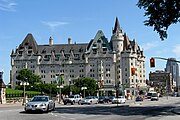
劳里埃城堡费尔蒙酒店(Château Laurier)[4][5] 1912 1980 渥太华
45°25′32.04″N 75°41′42.39″W / 45.4255667°N 75.6951083°W / 45.4255667; -75.6951083 (Château Laurier)
Exterior view of the west facade of the Château Laurier
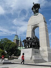
联邦广场(Confederation Square)[6] 1939 1984 渥太华
45°25′26.72″N 75°41′43.8″W / 45.4240889°N 75.695500°W / 45.4240889; -75.695500 (Confederation Square)
View of Confederation Square from the northeast
加拿大冷战博物馆(Diefenbunker)[7] 1959 1994 渥太华
45°21′06″N 76°02′50″W / 45.35167°N 76.04722°W / 45.35167; -76.04722 (Diefenbunker / Central Emergency Government Headquarters)
View of the Diefenbunker gate and entrance in Carp, Ottawa, Ontario, Canada
加拿大国家艺术中心(National Arts Centre)[8] 1969 2006 渥太华
45°25′23″N 75°41′38″W / 45.4230°N 75.6938°W / 45.4230; -75.6938 (National Arts Centre)
Exterior view of the National Arts Centre from Elgin Street
渥太华圣母圣殿主教座堂(Notre-Dame Cathedral Basilica)[9] 1842-1897 1990 渥太华
45°25′47″N 75°41′47″W / 45.42971°N 75.69646°W / 45.42971; -75.69646 (Notre-Dame Roman Catholic Basilica)
Exterior view of Notre-Dame Cathedral Basilica from Sussex Drive
国会大厦(Parliament Buildings)[10] 1865、1866、1876、1920 1976 渥太华
45°25′29″N 75°41′57″W / 45.4248°N 75.6992°W / 45.4248; -75.6992 (Parliament Buildings)
Exterior view of the Peace Tower clock
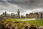
国会大厦公共场地(Public Grounds of the Parliament Buildings)[11] 1875 1976 渥太华
45°25′29″N 75°41′57″W / 45.424807°N 75.699234°W / 45.424807; -75.699234 (Parliament Buildings)
Exterior view of grounds in front of the Centre Block, with the East Block and Langevin Block in the image
丽都运河(Rideau Canal)[12] 1837 1925 渥太华金斯顿
45°25′33″N 75°41′50″W / 45.42583°N 75.69722°W / 45.42583; -75.69722 (Rideau Canal)
View of the Rideau Canal in downtown Ottawa
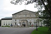
丽都厅(Rideau Hall)[13] 1838 1977 渥太华
45°26′39.73″N 75°41′9.5″W / 45.4443694°N 75.685972°W / 45.4443694; -75.685972 (Rideau Hall and Landscaped Grounds)
Rideau Hall front facade
皇家加拿大鑄幣廠(Royal Canadian Mint)[14] 1908 1979 渥太华
45°25′52.14″N 75°41′57.36″W / 45.4311500°N 75.6992667°W / 45.4311500; -75.6992667 (Royal Canadian Mint)
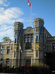
View of the Royal Canadian Mint from Sussex Drive

参考

  1. ^ Ottawa, Carp, Directory of Designations of National Historic Significance of Canada
  2. ^ Ottawa 互联网档案馆存檔,存档日期2012-10-06., National Historic Sites of Canada - administered by Parks Canada
  3. ^ Rideau Canal, Directory of Designations of National Historic Significance of Canada
  4. ^ Château Laurier. Canadian Register of Historic Places.
  5. ^ Hotel History页面存档备份,存于互联网档案馆), Fairmont Château Laurier - Fairmont Hotels
  6. ^ Confederation Square. Canadian Register of Historic Places.
  7. ^ Diefenbunker / Central Emergency Government Headquarters. Canadian Register of Historic Places.
  8. ^ National Arts Centre. Canadian Register of Historic Places.
  9. ^ Notre-Dame Roman Catholic Basilica. Canadian Register of Historic Places.
  10. ^ Parliament Buildings. Canadian Register of Historic Places.
  11. ^ Public Grounds of the Parliament Buildings. Canadian Register of Historic Places.
  12. ^ Rideau Canal. Canadian Register of Historic Places.
  13. ^ Rideau Hall and Landscaped Grounds. Canadian Register of Historic Places.
  14. ^ Royal Canadian Mint. Canadian Register of Historic Places.


Prefix: a b c d e f g h i j k l m n o p q r s t u v w x y z 0 1 2 3 4 5 6 7 8 9

Portal di Ensiklopedia Dunia