Saddlebag: a two-room house with a central chimney and one or two front doors[5]
Hall and parlor house: a two-room house, with one room (the hall) larger than the other (the parlor)[6]
Central-passage or central hallway\corridor: a three-room house, with a central hallway or passage running front-to-back between the two rooms on either side of the house[7]
Polyura athamas, the common nawab, is a species of fast-flying canopy butterfly found in tropical Asia. It belongs to the Charaxinae (rajahs and nawabs) in the brush-footed butterfly family (Nymphalidae).
(Please update the interwiki links on Wikidata of your language version of the article after each week's translation is finished so that all languages are linked to each other.)
Lưu Diệc Phi là một nữ diễn viên có thiên phú, có không gian diễn xuất vô cùng rộng, đây cũng chính xác là thiên phú có sẵn của cô. Bạn biết đó, Diệc Phi thật sự hiểu rất rõ về nhân vật của cô và toàn bộ bối cảnh của nhân vật, cô thật sự có thể nhập tâm sâu vào nhân vật của mình. Ở đời thường, cô ấy là một người vô cùng khiêm tốn, lễ phép và rất hiền hòa, là một người thông minh cùng hợp tác với cô ấy thật sự là một chuyện vô cùng vui.
Đạo diễn đoạt giải Oscar Bille August nhận xét về Lưu Diệc Phi.
"Tiếng rống của Gao Sư Tử" "Shishi, Hoeru!!"(獅子、吼える!!)
18 tháng 2 năm 2001 (2001-02-18)
Khi bốn chiến binh Gao đang chiến đấu với hai con quỷ Oruku, một chàng thanh niên đã dũng cảm sử dụng thần giao cách cảm để cứu một chú voi thoát khỏi bị cảnh sát bắn khi nó đang bị hoảng loạn.
02
"Hình dạng của tâm hồn thánh thiện" "Shūryō Ō, Tatsu!!"(精霊王、起つ!! (たつ))
25 tháng 2 năm 2001 (2001-02-25)
Trong lúc một con Oruku dây gai tấn công một chiếc taxi, Gao Đỏ chuyển đồ đạc đến Động Rùa và làm quen với các đồng đội mới.
03
"Đại bàng hoang dã biến mất" "Arawashi ga Kieru!!"(荒鷲が消える!!)
4 tháng 3 năm 2001 (2001-03-04)
Chúa tể đầu của dòng quỷ Oruku, Syutin chào đời và trực tiếp lãnh đạo JJ-Yabaiba chống lại các chiến binh Gao.
04
"Cả hai không bao giờ đầu hàng" "Futari de Nebagiba!!"(二人でネバギバ!!)
11 tháng 3 năm 2001 (2001-03-11)
Gao Đen (GaoBlack) và Gao Xanh (GaoBlue) bí mật đột nhập vào một ngôi đền ma để truy tìm Oruku, nhưng một trận động đất làm Gao Đen nỗ lực cứu Gao Xanh nhưng vô tình làm anh này bị thương.
05
"Ngọn núi di động" "Yama ga Ugoku!!"(山が動く!!)
18 tháng 3 năm 2001 (2001-03-18)
Trong lúc các siêu nhân đang nghiên cứu cuốn cổ thư lấy được ở tập trước, Tetomu đã phát hiện ra vật bên trong hòn đá là một viên gọc Gao, Gao Voi Khổng lồ.
06
"Con bò lo lắng" "Ushi, Kogareru!!"(牛、焦がれる!!)
25 tháng 3 năm 2001 (2001-03-25)
Các chiến binh Gao bất ngờ phục kích Oruku đám cưới và truy đuổi nó đến khách sạn thì mất dấu ở hành lang, cả đội chia ra mỗi người tìm một phòng.
07
"Lời giấc chiêm bao" "Yume ga Kataru!!"(夢が語る!!)
1 tháng 4 năm 2001 (2001-04-01)
Một làn sương mù bí ẩn bất ngờ tấn công một tàu đánh cá trên biển.
08
"Chú chó thân yêu đang chạy" "Inu, Hashiru!!"(犬、走る!!)
8 tháng 4 năm 2001 (2001-04-08)
Ở Động Rùa, Gao Trắng nhặt được một chiếc ví và đem bức hình một cô gái cho các đồng đội xem, khiến cả bọn nghĩ đó là bạn gái Gao Đỏ, sau đó Gao Đỏ phát hiện đó là ví của mình.
09
"Những nụ cười của cặp song sinh" "Futago ga Hohoemu"(双子が微笑む)
15 tháng 4 năm 2001 (2001-04-15)
Một ngày yên bình không có Oruku giúp các chiến binh Gao có thể thoải mái làm việc mà họ thích.
10
"Tiếng gọi của Mặt Trăng" "Tsuki ga Maneku!!"(月が招く!!)
22 tháng 4 năm 2001 (2001-04-22)
Gao Đỏ đã lên Thiên Đảo để thăm bệnh tình của Gao Sư Tử.
Bitterlings transfer responsibility for the care of their young to mussels. This male bitterling is exhibiting spawning colours
Mekong beach near Don Loppadi
Transport of buffalos on the Mekong (from Don Det)
Six children in the Mekong with buffalos and boat
Mekong pirogue at sunset near Don Puay
Man watering cucumbers plantation on small island
Kitchen garden on a Mekong bank in Don Loppadi
Flooded Albizia Saman (rain tree) near Don Loppadi
Wooden fence in Si Phan Don
Children playing at sunset on a Mekong bank near Don Loppadi
Nhà sử học Bertram Wyatt-Brown nói về đấu tay đôi tại Hoa Kỳ như sau:
Những cuộc đấu tay đôi trong độ tuổi thanh thiếu niên là không phổ biến, ít nhất là tại miền Nam California và New Orleans… Có 3 điểm kì lạ xuất hiện trong các cuộc đấu tay đôi. Đầu tiên, mặc dù đấu tay đôi được hạn chế trong những tầng lớp cao trong xã hội nhưng nó cũng được những người bị đánh giá thấp kém như những người chăn heo sử dụng để giải quyết các mâu thuẫn của riêng mình. Thứ hai, vì sự đồng thuận về các khái niệm “danh dự” cao và thấp, đấu tay đôi không hoàn toàn là không bình đẳng về giai cấp. Nó cho phép những người có đẳng cấp thấp trở thành, nhưng không hoàn toàn, những người có địa vị cao, và cho phép những người theo sau lợi dụng những người có địa vị cao theo mục đích của họ. Thứ ba, một mong muốn về sự tôn trọng và hình ảnh trong mắt người khác, điều mà đẩy những người đàn ông đi đến những hành động mang tính danh dự này không phải lúc nào cũng khiến họ mãn nguyện nhưng nó là một cái “lý do” để giải thích cho những vấn đề cá nhân không thể giải quyết được.
Những trận đấu tay đôi đơn giản được chiến đấu để bảo vệ danh dự cá nhân ở những vùng quê tại biên giới Hoa Kỳ, cái mà chịu ảnh hưởng một phần từ “Bộ luật đấu tay đôi” được mang tới từ những người di cư phía Nam.[14][15]
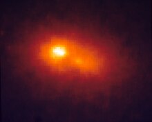
M31 nhìn qua kính viễn vọng nhỏ.
Hình chụp nhân thiên hà Andromeda của Kính viễn vọng Hubble (HST) cho thấy có thể có hai cấu trúc bên trong nhân. NASA/ESA.
Lorem ipsum dolor sit amet, consectetur adipiscing elit, sed do eiusmod tempor incididunt ut labore et dolore magna aliqua. Ut enim ad minim veniam, quis nostrud exercitation ullamco laboris nisi ut aliquip ex ea commodo consequat. Duis aute irure dolor in reprehenderit in voluptate velit esse cillum dolore eu fugiat nulla pariatur. Excepteur sint occaecat cupidatat non proident, sunt in culpa qui officia deserunt mollit anim id est laborum.
Curabitur pretium tincidunt lacus. Nulla gravida orci a odio. Nullam varius, turpis et commodo pharetra, est eros bibendum elit, nec luctus magna felis sollicitudin mauris. Integer in mauris eu nibh euismod gravida. Duis ac tellus et risus vulputate vehicula. Donec lobortis risus a elit. Etiam tempor. Ut ullamcorper, ligula eu tempor congue, eros est euismod turpis, id tincidunt sapien risus a quam. Maecenas fermentum consequat mi. Donec fermentum. Pellentesque malesuada nulla a mi. Duis sapien sem, aliquet nec, commodo eget, consequat quis, neque. Aliquam faucibus, elit ut dictum aliquet, felis nisl adipiscing sapien, sed malesuada diam lacus eget erat. Cras mollis scelerisque nunc. Nullam arcu. Aliquam consequat. Curabitur augue lorem, dapibus quis, laoreet et, pretium ac, nisi. Aenean magna nisl, mollis quis, molestie eu, feugiat in, orci. In hac habitasse platea dictumst.
Một bài viết GA (good article) đã dịch thuật tốt toàn bộ từ Wikipedia tiếng Anh có thể được phép đề cử để trở thành BVCL (bài viết chọn lọc) tại Wikipedia tiếng Việt chúng ta không, mặc dù không có bổ sung gì đáng kể?
Rhinoceroses in art
A wine vessel in the form of a bronze rhinoceros with silver inlay, from the Western Han (202 BC – 9 AD) period of China, sporting a saddle on its back
Chào mừng tới Dự án Taylor Swift! Đây là một dự án wiki được lập ra trên Wikipedia để cải thiện và viết mới các bài viết về Taylor Swift, nhạc sỹ kiêm nhà soạn nhà người Mỹ. Nếu bạn quan tâm tới chủ đề hay giúp đỡ, hãy tham gia dự án, đưa ra những ý tưởng tại trang thảo luận và xem danh sách việc cần làm ở phía dưới.
Thành phố tự quản Ribnica tại miền nam Slovenia. Bên trái là nhà thờ Thánh Stephen, bên phải của ảnh là Lâu đài Ribnica.
The productivity of marine fisheries is largely determined by marine topography, including its interaction with ocean currents and the diminishment of sunlight with depth.
The productivity of marine fisheries is largely determined by marine topography, including its interaction with ocean currents and the diminishment of sunlight with depth.
An ocean current is continuous, directed movement of ocean water. Ocean currents are rivers of relatively warm or cold water within the ocean. The currents are generated from the forces acting upon the water like the planet rotation, the wind, the temperature and salinity (hence isopycnal) differences and the gravitation of the moon. The depth contours, the shoreline and other currents influence the current's direction and strength.
More on currents
Example of different ocean currents in the Southern OceanA summary of the path of the Thermohaline Circulation. Blue paths represent deep-water currents, while red paths represent surface currentsA schematic of modern thermohaline circulation
Ocean currents can flow for thousands of kilometers. Surface ocean currents are generally wind driven and develop their typical clockwise spirals in the northern hemisphere and counter-clockwise rotation in the southern hemisphere because of the imposed wind stresses. In wind driven currents, the Ekman spiral effect results in the currents flowing at an angle to the driving winds. The areas of surface ocean currents move somewhat with the seasons; this is most notable in equatorial currents.
Deep ocean currents are driven by density and temperature gradients. Thermohaline circulation, also known as the ocean's conveyor belt, refers to the deep ocean density-driven ocean basin currents. These currents, which flow under the surface of the ocean and are thus hidden from immediate detection, are called submarine rivers. Upwelling and downwelling areas in the oceans are areas where significant vertical movement of ocean water is observed.
Surface currents make up about 10% of all the water in the ocean. Surface currents are generally restricted to the upper 400 meters of the ocean. The movement of deep water in the ocean basins is by density driven forces and gravity. The density difference is a function of different temperatures and salinity. Deep waters sink into the deep ocean basins at high latitudes where the temperatures are cold enough to cause the density to increase. The main causes of currents are: solar heating, winds and gravity.
Ocean currents are also very important in the dispersal of many life forms. A dramatic example is the life-cycle of the eel. Currents also determine the disposition of marine debris.
Gyres and upwelling
Map of Ocean GyresMap of regions of upwelling
Oceanic gyres are large-scale ocean currents caused by the Coriolis effect. Wind-driven surface currents interact with these gyres and the underwater topography, such as seamounts and the edge of continental shelves, to produce downwellings and upwellings.[16] These can transport nutrients and provide feeding grounds for plankton eating forage fish. This in turn draws larger fish that prey on the forage fish, and can result in productive fishing grounds. Most upwellings are coastal, and many of them support some of the most productive fisheries in the world, such as small pelagics (sardines, anchovies, etc.). Regions of upwelling include coastal Peru, Chile, Arabian Sea, western South Africa, eastern New Zealand and the California coast.
* The Humboldt Current. This gyre produces a cold, low-salinity ocean current that flows north-westward along the west coast of South America from the southern tip of Chile to northern Peru. This results in the most prominent upwelling system in the world, supporting an extraordinary abundance of marine life. Upwelling occurs off Peru year-round and off Chile during the spring and summer. Approximately 18-20% of the world’s fish catch comes from the Humboldt Current LME. The species are mostly pelagic: sardines, anchovies and jack mackerel. The LME’s high primary and secondary productivity supports other important fishery resources as well as marine mammals.
The California Current.This is a Pacific Oceancurrent that moves south along the western coast of North America, beginning off southern British Columbia, and ending off southern Baja California. The movement of northern waters southward makes the coastal waters cooler than coastal areas of comparable latitude on the east coast of the United States. Extensive upwelling of colder sub-surface waters occurs, caused by the prevailing northwesterly winds acting through the Ekman Effect. The winds drive surface water to the right of the wind flow, that is offshore, which draws water up from below to replace it. The upwelling further cools the already cool California Current. The cold water is highly productive due to the upwelling, which brings to the surface nutrient-rich sediments, supporting large populations of whales, seabirds and important fisheries. During El Niño events, the California Current is disrupted, leading to declines in phytoplankton, resulting in cascading effects up the food chain, such as declines in fisheries, seabird breeding failures and marine mammal mortality. In 2005, a failure in the otherwise predictable upwelling events, unassociated with El Niño, caused a collapse in krill in the current, leading to similar effects.[17]
Phytoplankton is usually the primary producer (the first level in the food chain or the first trophic level). Phytoplankton converts inorganic carbon into protoplasm. Phytoplankton is consumed by microscopic animals called zooplankton. These are the second level in the food chain, and include krill, the larva of fish, squid, lobsters and crabs–as well as the small crustaceans called copepods, and many other types. Zooplankton is consumed both by other, larger predatory zooplankters and by fish (the third level in the food chain). Fish that eat zooplankton could constitute the fourth trophic level, while seals consuming the fish are the fifth. Alternatively, for example, whales may consume zooplankton directly - leading to an environment with one less trophic level.
Antarctic krill comprise about 0.7% of the Earth's biomass, the highest of any single animal species.[19]As a group, copepods form the largest animal biomass on earth.
Global primary production can be estimated from satellite observations. Satellites scan the normalised difference vegetation index (NDVI) over terrestrial habitats, and scan sea-surface chlorophyll levels over oceans. This results in 56.4 billion tonnesC/yr (53.8%), for terrestrial primary production, and 48.5 billion tonnes C/yr for oceanic primary production.[20] Thus, the total photoautotrophic primary production for the Earth is about 104.9 billion tonnes C/yr. This translates to about 426 gC/m²/yr for land production (excluding areas with permanent ice cover), and 140 gC/m²/yr for the oceans.
However, there is a much more significant difference in standing stocks - while accounting for almost half of total annual production, oceanic autotrophs account for only about 0.2% of the total biomass.
The most successful animal species, in terms of biomass, is probably the Antarctic krill, Euphausia superba, with a biomass of about 500 million tonnes.[19][21] However, as a group, the small aquatic crustaceans called copepods form the largest animal biomass on earth.[22]
Source: Whittaker, R. H.; Likens, G. E. (1975). “The Biosphere and Man”. Trong Leith, H & Whittaker, R H (biên tập). Primary Productivity of the Biosphere. Springer-Verlag. tr. 305–328. ISBN0-387-07083-4.Quản lý CS1: nhiều tên: danh sách biên tập viên (liên kết); Ecological Studies Vol 14 (Berlin)
Aquatic habitats have been classified into marine and freshwaterecoregions by the Worldwide Fund for Nature (WWF). An ecoregion is defined as a "relatively large unit of land or water containing a characteristic set of natural communities that share a large majority of their species, dynamics, and environmental conditions (Dinerstein et al. 1995, TNC 1997).[23]
Estuaries are semi-enclosed coastal bodies of water with one or more rivers or streams flowing into therm, and with a free connection to the open sea.[24] Estuaries are often associated with high rates of biological productivity. They are small, in demand, impacted by events far upstream or out at sea, and concentrate materials such as pollutants and sediments.[25][26]
Lagoons are bodies of comparatively shallow salt or brackish water separated from the deeper sea by a shallow or exposed sandbank, coral reef, or similar feature. Lagoon refers to both coastal lagoons formed by the build-up of sandbanks or reefs along shallow coastal waters, and the lagoons in atolls, formed by the growth of coral reefs on slowly sinking central islands. Lagoons that are fed by freshwater streams are estuaries.
The intertidal zone (foreshore) is the area that is exposed to the air at low tide and submerged at high tide, for example, the area between tide marks. This area can include many different types of habitats, including steep rocky cliffs, sandy beaches or vast mudflats. The area can be a narrow strip, as in Pacific islands that have only a narrow tidal range, or can include many meters of shoreline where shallow beach slope interacts with high tidal excursion.
Fixed-net fishing on the littoral zone along the Suhua Highway on the East coast of Taiwan
The littoral zone is the part of the ocean closest to the shore. The word littoral comes from the Latinlitoralis, which means seashore.[27] The littoral zone extends from the high-water mark to near shore areas that are permanently submerged, and includes the intertidal zone. Definitions vary. Encyclopædia Britannica defines the littoral zone in a thoroughly vague way as the "marine ecological realm that experiences the effects of tidal and longshore currents and breaking waves to a depth of 5 to 10 metres (16 to 33 feet) below the low-tide level, depending on the intensity of storm waves".[28] The US Navy defines it as extending "from the shoreline to 600 feet (183 meters) out into the water"[29]
The sublittoral zone is the part of the ocean extending from the seaward edge of the littoral zone to the edge of the continental shelf.[30] It is sometimes called the neritic zone. Websters defines the neritic zone as the region of shallow water adjoining the seacoast. The word neritic perhaps comes from the new Latinnerita, which refers to a genus of marine snails, 1891.[31] The sublittoral zone is relatively shallow, extending to about 200 meters (100 fathoms), and generally has well-oxygenated water, low water pressure, and relatively stable temperature and salinity levels. These, combined with presence of light and the resulting photosynthetic life, such as phytoplankton and floating sargassum,[32] make the sublittoral zone the location of the majority of sea life.
The shelf usually ends at a point of decreasing slope (called the shelf break). The sea floor below the break is the continental slope. Below the slope is the continental rise, which finally merges into the deep ocean floor, the abyssal plain. The continental shelf and the slope are part of the continental margin.
Continental shelves are shallow (averaging 140 metres or 460 feet), and the sunlight available means they can teem with life. The shallowest parts of the continental shelf are called fishing banks.[33] There the sunlight penetrates to the seafloor and the plankton, on which fish feed, thrive.
Continental shelves : Details
The character of the shelf changes dramatically at the shelf break, where the continental slope begins. With a few exceptions, the shelf break is located at a remarkably uniform depth of roughly 140 m (460 ft); this is likely a hallmark of past ice ages, when sea level was lower than it is now.[34]
The width of the continental shelf varies considerably – it is not uncommon for an area to have virtually no shelf at all, particularly where the forward edge of an advancing oceanic plate dives beneath continental crust in an offshore subduction zone such as off the coast of Chile or the west coast of Sumatra. The largest shelf – the Siberian Shelf in the Arctic Ocean – stretches to 1500 kilometers (930 miles) in width. The South China Sea lies over another extensive area of continental shelf, the Sunda Shelf, which joins Borneo, Sumatra, and Java to the Asian mainland. Other familiar bodies of water that overlie continental shelves are the North Sea and the Persian Gulf. The average width of continental shelves is about 80 km (50 mi). The depth of the shelf also varies, but is generally limited to water shallower than 150 m (490 ft).[35]
Combined with the sunlight available in shallow waters, the continental shelves teem with life compared to the biotic desert of the oceans' abyssal plain. The pelagic (water column) environment of the continental shelf constitutes the neritic zone, and the benthic (sea floor) province of the shelf is the sublittoral zone.[36]
Coral reefs
Locations of coral reefs.
Coral reefs are aragonite structures produced by living organisms, found in shallow, tropical marine waters with little to no nutrients in the water. High nutrient levels such as those found in runoff from agricultural areas can harm the reef by encouraging the growth of algae.[37] Although corals are found both in temperate and tropical waters, reefs are formed only in a zone extending at most from 30°N to 30°S of the equator.
Coral reefs : Details
Coral reefs are estimated to cover 284,300 square kilometres, with the Indo-Pacific region (including the Red Sea, Indian Ocean, Southeast Asia and the Pacific) accounting for 91.9% of the total.[cần dẫn nguồn] Southeast Asia accounts for 32.3% of that figure, while the Pacific including Australia accounts for 40.8%. Atlantic and Caribbean coral reefs only account for 7.6% of the world total.[38]
Coral reefs are either restricted or absent from the west coast of the Americas, as well as the west coast of Africa. This is due primarily to upwelling and strong cold coastal currents that reduce water temperatures in these areas.[39] Corals are also restricted from off the coastline of South Asia from Pakistan to Bangladesh.[38] They are also restricted along the coast around north-eastern South America and Bangladesh due to the release of vast quantities of freshwater from the Amazon and Ganges Rivers respectively.[cần dẫn nguồn]
Famous coral reefs and reef areas of the world include:
The Belize Barrier Reef - second largest in the world, stretching from southern Quintana Roo, Mexico and all along the coast of Belize down to the Bay Islands of Honduras.
The Red Sea Coral Reef - located off the coast of Egypt and Saudi Arabia.
Many of the numerous reefs found scattered over the Maldives
The New Caledonia Barrier Reef - second longest double barrier reef in the world, with a length of about 1.500 km (932 mi).
Coral reefs support an extraordinary biodiversity; although they are located in nutrient-poor tropical waters. The process of nutrient cycling between corals, zooxanthellae, and other reef organisms provides an explanation for why coral reefs flourish in these waters: recycling ensures that fewer nutrients are needed overall to support the community.
Coral reefs are home to a variety of tropical or reef fish, such as the colorful parrotfish, angelfish, damselfish, and butterflyfish. Other fish groups found on coral reefs include groupers, snappers, grunts and wrasses. Over 4,000 species of fish inhabit coral reefs.[38] It has been suggested that the high number of fish species that inhabit coral reefs are able to coexist in such high numbers because any free living space is rapidly inhabited by the first planktonic fish larvae that occupy it. These fish then inhabit the space for the rest of their life. The species that inhabit the free space is random and has therefore been termed 'a lottery for living space'.[40]
Bioerosion (coral damage) such as this may be caused by coral bleaching.[42]
Human activity may represent the greatest threat to coral reefs living in Earth's oceans. In particular, pollution and over-fishing are the most serious threats to these ecosystems. Physical destruction of reefs due to boat and shipping traffic is also a problem. The live food fish trade has been implicated as a driver of decline due to the use of cyanide and
disaster for peoples living in the tropics. Hughes, et al., (2003), writes that "with increased human population and improved storage and transport systems, the scale of human impacts on reefs has grown exponentially. For example, markets for fishes and other natural resources have become global, supplying demand for reef resources far removed from their tropical sources."[43]
Currently researchers are working to determine the degree various factors impact the reef systems. The list of factors is long but includes the oceans acting as a carbon dioxide sink, changes in Earth's atmosphere, ultraviolet light, ocean acidification, biological virus, impacts of dust storms carrying agents to far flung reef systems, various pollutants, impacts of algal blooms and others. Reefs are threatened well beyond coastal areas and so the problem is broader than factors from land development and pollution though those are too causing considerable damage.
Southeast Asian coral reefs are at risk from damaging fishing practices (such as cyanide and blast fishing), overfishing, sedimentation, pollution and bleaching. A variety of activities, including education, regulation, and the establishment of marine protected areas are under way to protect these reefs. Indonesia, for example has nearly 33.000 dặm vuông Anh (85.000 km2) of coral reefs. Its waters are home to a third of the world’s total corals and a quarter of its fish species. Indonesia's coral reefs are located in the heart of the Coral Triangle and have been victim to destructive fishing, unregulated tourism, and bleaching due to climatic changes. Data from 414 reef monitoring stations throughout Indonesia in 2000 found that only 6% of Indonesia’s coral reefs are in excellent condition, while 24% are in good condition, and approximately 70% are in poor to fair condition (2003 The Johns Hopkins University).
General estimates show approximately 10% of the coral reefs around the world are already dead.[44][45] Problems range from environmental effects of fishing techniques, described above, to ocean acidification.[46]Coral bleaching is another manifestation of the problem and is showing up in reefs across the planet.
NInhabitants of Ahus Island, Manus Province, Papua New Guinea, have followed a generations-old practice of restricting fishing in six areas of their reef lagoon. While line fishing is permitted, net and spear fishing are restricted based on cultural traditions. The result is that both the biomass and individual fish sizes are significantly larger in these areas than in places where fishing is completely unrestricted.[47][48]
It is estimated that about 60% of the world’s reefs are at risk due to destructive, human-related activities. The threat to the health of reefs is particularly strong in Southeast Asia, where an enormous 80% of reefs are considered endangered.
In the deep ocean, much of the ocean floor is a flat, featureless underwater desert called the abyssal plain. Many pelagic fishmigrate across these plains in search of spawning or different feeding grounds. Smaller migratory fish are followed by larger predator fish and can provide rich, if temporary, fishing grounds.
A seamount is an underwater mountain, rising from the seafloor that does not reach to the water's surface (sea level), and thus is not an island. They are defined by oceanographers as independent features that rise to at least 1,000 meters above the seafloor. Seamounts are common in the Pacific Ocean. Recent studies suggest there may be 30,000 seamounts in the Pacific, about 1,000 in the Atlantic Ocean and an unknown number in the Indian Ocean.[51]
Seamounts : Details
Seamounts often project upwards into shallower zones more hospitable to sea life, providing habitats for marine species that are not found on or around the surrounding deeper ocean bottom. In addition to simply providing physical presence in this zone, the seamount itself may deflect deep currents and create upwelling. This process can bring nutrients into the photosynthetic zone, producing an area of activity in an otherwise desert-like open ocean. Seamounts may thus be vital stopping points for some migratory animals such as whales. Some recent research indicates whales may use such features as navigational aids throughout their migration.
Due to the larger populations of fish in these areas overexpoitation by the fishing industry has caused some seamount fauna populations to decrease considerably.
The primary productivity of the epipelagic waters above the submerged peak can often be enhanced by the hydrographic conditions of the seamount.[52] This increases the densities of the zooplankton and leads to the high concentrations of fish in these areas. Another theory for this is that the fish are sustained on the diurnal migration of zooplankton being interrupted by the presence of the seamount, and causing the zooplankton to stay in the area. It is also possible that the high densities of fishes has more to do with the fish life histories and interaction with the benthic fauna of the seamount.[53]
The benthic fauna of the seamounts is dominated by suspension feeders, including sponges and true corals. For some seamounts that peaks at 200–300 metres below the surface benthic macroalgae is common. The sedimentary infauna is dominated by polychaete worms.
For a long time it has been surmised that many pelagic animals visit seamounts to gather food, but proof this of this aggregating effect has been lacking. The first demonstration of this conjecture has recently been published [54]
During the 1960s, Russia, Australia and New Zealand started to look for new stocks of fish and began to trawl the seamounts. The majority of the invertebrates brought up are corals, and are mainly used for the jewelry trade. The two major fish species were the orange roughy (Hoplostethus atlanticus) and pelagic armourhead (Pseudopentaceros wheeleri), which were quickly overexploited due to lack of knowledge of the longevity of the fish, late maturity, low fecundity, small geographic range and recruitment to the fishery. As well as the fishes being overexploited the benthic communities were destroyed by the trawling gear.[55]
CenSeam, Census of Marine Life project CenSeam: a global census of marine life on seamounts
hiển thị bản mẫu thu gọn về thanh tiêu đề nếu có một hoặc nhiều {{hộp điều hướng}}, {{thanh bên}}, hay các bảng khác trên trang cũng có thuộc tính đóng mở
hiển thị bản mẫu đầy đủ nếu không có mục nào khác trên trang có thuộc tính đóng mở
Nếu tham số không được chỉ định, trạng thái hiển thị mặc định ban đầu của bản mẫu sẽ là autocollapse (xem tham số |state= trong mã bản mẫu).
Albertosaurus is a predatory theropod dinosaur, a member of the Tyrannosauridae. In Primeval: New World, an Albertosaurus killed and devoured Brooke, Evan Cross' wife and an alternate timeline version of Mac Rendall. In the series, its preorbital horns are greatly enlarged, similar to those of a Carnotaurus with similar skin textures. Evan encounters the same Albertosaurus as a hallucination after accidentally ingesting the snot of a Pachycephalosaurus. On close inspection, the Albertosaurus can be recognised by its missing right arm, and its body was covered in numerous old cuts and slashes.
Những tấm ảnh chụp bởi Uchida Kuichi trong các năm 1872 (trái) và 1873 (phải). Trong hình bên trái, Thiên hoàng mặc trang phục Sokuda còn trong hình bên phải thì ông mặc quân phục
"Tôi biết điều này chắc chắn đúng, vì Kinh thánh luôn luôn chắc chắn đúng."[57]
The translation request
Hi! Could I ask you to translate the article which you can find below into Vietnamese? Please help me to show our language to the world – the article is quite short and has been selected from English and Silesian article and shortened as possible to contain only the basic informations. If you would finish, please, make me know on my Silesian or Polish discussion. Thanks in advance. PS. If you want me to translate any article into Polish or Silesian, contact me without hesistation.
So, here’s the text to translation:
The Silesian language (Silesian: ślůnsko godka, ślůnski, sometimes also pů našymu) is a language spoken by people in the Upper Silesia region in Poland, but also in Czech Republic and Germany. In 2002 about 56 000 declared Silesian as their native language, but the number of speakers is estimated on 1 250 000.
Silesian is closely related to Polish language, that’s why it is considered as a dialect of Polish by some linguistics.
Alphabet
There’s not one Silesian alphabet. The Silesian speakers are used to write their language with the Polish characters. In 2007 was invented the new Silesian alphabet, based on all of the Silesian scripts (there’s 10 of them). It is widely used on the Internet, as well as in the Silesian Wikipedia.
Aa Bb Cc Ćć Čč Dd Ee Ff Gg Hh Ii Jj Kk Ll Mm Nn Ńń Oo Pp Rr Řř Ss Śś Šš Tt Uu Ůů Ww Yy Zz Źź Žž
Vui lòng bỏ qua thư mời này nếu người tôi gửi không phải là cựu học sinh hay giáo viên trường THPT Minh Khai. Thành thật xin lỗi, EsVie (thảo luận) 03:08, ngày 9 tháng 1 năm 2009 (UTC).
Chào bạn, các thành viên Wikipedia rất vui lòng hoan nghênh bạn nếu các đóng góp của bạn có ích cho cộng đồng, nhưng nếu bạn chỉ quan tâm tới chuyện quảng cáo như bạn đã làm, thì chúng tôi ở đây cũng rất vui lòng chống lại bạn đến cùng. Mọi hành vi của bạn sẽ bị theo dõi, mọi bài quảng cáo bạn tạo sẽ bị xóa, tất cả thời gian và công sức bạn bỏ ra sẽ trở nên hoàn toàn vô nghĩa, và chuyện lẩn tránh dưới một IP hoặc tạo tài khoản khác không giúp ích gì. Vì thế, hãy cân nhắc trước khi tiếp tục hành vi quảng cáo.
Đây là một trang thành viênWikipedia. Đây không phải là một bài viết bách khoa. Nếu bạn tìm thấy trang này tại bất kỳ trang web nào ngoài Wikipedia, nghĩa là bạn đang đọc một bản sao của Wikipedia. Xin lưu ý rằng trang này có thể đã bị lỗi thời và chủ nhân của trang có thể không có mối liên hệ nào với bất kỳ website nào khác ngoài Wikipedia.
Bản chính của trang này nằm tại https://vi.wikipedia.org/wiki/Thành viên:Phương Huy/Linh tinh.
^Lỗi chú thích: Thẻ <ref> sai; không có nội dung trong thẻ ref có tên ukrinform-levin
^Harris 2006, tr. 892, Single-pile house: A house that is only one room deep"Lỗi sfn: không có mục tiêu: CITEREFHarris2006 (trợ giúp)
^Cloues 2005, Single Pen: "A one-room house, usually gable-roofed with an end chimney"Lỗi sfnm: không có mục tiêu: CITEREFCloues2005 (trợ giúp); Harris 2006, tr. 490, Hall: "4. A small, relatively primitive dwelling having a one-room plan."Lỗi sfnm: không có mục tiêu: CITEREFHarris2006 (trợ giúp)
^Cloues 2005, Double Pen: "A two-room house with two front doors, usually gable-roofed with end chimneys"Lỗi sfn: không có mục tiêu: CITEREFCloues2005 (trợ giúp)
^Cloues 2005, Saddlebag: "A two-room house with a central chimney and one or two front doors, usually gable-roofed"Lỗi sfn: không có mục tiêu: CITEREFCloues2005 (trợ giúp)
^Cloues 2005, Hall-Parlor: "A two-room house with unequal-sized rooms and one front door, usually gable-roofed"Lỗi sfn: không có mục tiêu: CITEREFCloues2005 (trợ giúp)
^Cloues 2005, Central Hallway: "A two-room house with a central hall and centered front door, usually gable-roofed with end chimneys"Lỗi sfn: không có mục tiêu: CITEREFCloues2005 (trợ giúp)
^Cloues 2005, Dogtrot: "A two-room house with an open center passage"Lỗi sfn: không có mục tiêu: CITEREFCloues2005 (trợ giúp)
^Harris 2006, tr. 328, Double-pile house: A house that is two rooms deep"Lỗi sfn: không có mục tiêu: CITEREFHarris2006 (trợ giúp)
^Cloues 2005, Shotgun: "A one-room wide house, two or more rooms deep, without a hallway; gable- or hip-roofed"Lỗi sfn: không có mục tiêu: CITEREFCloues2005 (trợ giúp)
^Harris 2006, tr. 887–888, Side-hall plan, side passage plan: "A floor plan of a house having a corridor that runs from the front to the back of the house along one exterior wall; all rooms are located on the same side of the corridor."Lỗi sfn: không có mục tiêu: CITEREFHarris2006 (trợ giúp)
^Lỗi chú thích: Thẻ <ref> sai; không có nội dung trong thẻ ref có tên toei.co
^ abLỗi chú thích: Thẻ <ref> sai; không có nội dung trong thẻ ref có tên Balon
^DeArment, Robert K. Deadly Dozen: Forgotten Gunfighters of the Old West, Volume 3.
^ abcdSpalding, Mark, Corinna Ravilious, and Edmund Green. 2001. World Atlas of Coral Reefs. Berkeley, CA: University of California Press and UNEP/WCMC.
^Nybakken, James. 1997. Marine Biology: An Ecological Approach. 4th ed. Menlo Park, CA: Addison Wesley.
^Coexistence of coral reef fishes—a lottery for living space
PF Sale 1978 - Environmental Biology of Fishes, 1978
^Castro, Peter and Michael Huber. 2000. Marine Biology. 3rd ed. Boston: McGraw-Hill.
^Hughes, et al. 2003. Climate Change, Human Impacts, and the Resilience of Coral Reefs. Science. Vol 301 15 August 2003
^Save Our Seas, 1997 Summer Newsletter, Dr. Cindy Hunter and Dr. Alan Friedlander
^Tun, K., L.M. Chou, A. Cabanban, V.S. Tuan, Philreefs, T. Yeemin, Suharsono, K.Sour, and D. Lane, 2004, p:235-276 in C. Wilkinson (ed.), Status of Coral Reefs of the world: 2004.
^Kleypas, J.A., R.A. Feely, V.J. Fabry, C. Langdon, C.L. Sabine, and L.L. Robbins, 2006, Impacts of Ocean Acidification on Coral Reefs and Other Marine Calcifiers: A guide for Future Research, NSF, NOAA, & USGS, 88 pp.
^Cinner, J. et al. (2005). Conservation and community benefits from traditional coral reef management at Ahus Island, Papua New Guinea. Conservation Biology 19 (6), 1714–1723
^Boehlert, G. W. and Genin, A. 1987. A review of the effects of seamounts on biological processes. 319-334. Seamount, islands and atolls. Geophysical Monograph 43, edited by B. H. Keating, P. Fryer, R. Batiza, and G. W. Boehlert.
^Morato, T., Varkey, D.A., Damaso, C., Machete, M., Santos, M., Prieto, R., Santos, R.S. and Pitcher, T.J. (2008) Evidence of a seamount effect on aggregating visitors. Marine Ecology Progress Series 357: 23-32.
^Thorson, T.B. (1983). “Observations on the morphology, ecology and life history of the euryhaline stingray, Dasyatis guttata (Bloch and Schneider) 1801”. Acta Biologica Venezuelica. 11 (4): 95–126.
^Lỗi chú thích: Thẻ <ref> sai; không có nội dung trong thẻ ref có tên Daily Mail report


.jpg)


_-_Indian_Nawab.jpg)


.jpg)


.jpg)


_in_the_Mekong.jpg)


.jpg)


.jpg)
.JPG)


_1.jpg)


![Longnose stingray[56]](T%E1%BA%ADp_tin:Dasyatis_guttata.jpg)


.jpg)


.svg)
.svg)


_in_Vietnamese.jpg)