Amazon NaddiRio Amazonas , Río Amazonas
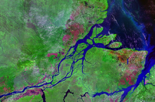
Amazon Delta ke satellite chhaapa
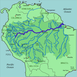
Amazon Naddi aur uske drainage basin
Native name Amazonas (Portuguese ) Des Peru , Colombia , Brazil Cities Iquitos (Peru); Leticia (Colombia);Tabatinga (Brazil); Tefé (Brazil);Itacoatiara (Brazil) Parintins (Brazil);Óbidos (Brazil); Santarém (Brazil);Almeirim (Brazil); Macapá (Brazil);Manaus (Brazil)Template:Infobox river/source Template:Infobox river/source Template:Infobox river/source Template:Infobox river/source Template:Infobox river/source Template:Infobox river/source Naddi ke muh Atlantic Ocean • location
Brazil • coordinates
0°42′28″N 50°5′22″W / 0.70778°N 50.08944°W / 0.70778; -50.08944 [ 1] Lambaai 3,750 km (2,330 mi)[ 2] (Amazon–Ucayali–Tambo–Ené–Apurímac Template:Refn
(Amazon–Marañón 5,700 km (3,500 mi)[ 2] units? Basin ke size (with Tocantins )
6,743,000 km2 (2,603,000 sq mi)[ 3] 2 (2,700,000 sq mi)[ 4] [ 5]
(5,956,000–6,112,000 km2 without Tocantins [ 6] [ 5] units? Chaurraai • minimum 700 m (2,300 ft) (Upper Amazon);Itacoatiara , Lower Amazon)[ 7] units? • average 3 km (1.9 mi) (Middle Amazon);[ 7] [ 8] units? • maximum 10–14 km (6.2–8.7 mi) (Lower Amazon);[ 7] [ 9] [ 10] units? Gahiraai • average 15–45 m (49–148 ft) (Middle Amazon);[ 7] • maximum 150 m (490 ft) (Itacoatiara ); 130 m (430 ft) (Óbidos )[ 7] [ 8] Template:Infobox river/discharge Template:Infobox river/discharge Template:Infobox river/discharge Template:Infobox river/discharge Template:Infobox river/discharge Naddi ke system Amazon River Tributaries • left Marañón , Nanay , Napo , Ampiyaçu,Putumayo , Japurá , Badajós , Manacapuru ,Rio Negro , Urubu , Uatumã , Nhamundá ,Trombetas , Maicurú , Curuá , Paru , Jari • right Ucayali , Jandiatuba , Javary , Jutai , Juruá ,Tefé , Coari , Purús , Madeira ,Paraná do Ramos , Tapajós , Curuá-Una ,Xingu , Pará , Tocantins , Acará , Guamá
Satellite image of the mouth of the Amazon riverAmazon naddi (jiske Spanish aur Portuguese bhasa me Rio Amazonas bolaa jaawe hae, ek naddi hae jon ki South America ke tropical jangle me se flow howe hae. Ii jaada kar ke Brazil me hae aur samundar me jaae ke Atlantic Ocean me nikle hae. II Nile Naddi ke baad me dunia ke duusra sab se lamba nadi hae. Agar jo dekha jaae ki isme se ketna paani flow hoe hae tab ii dunia ke sab se barraa naddi hae. Ii etna lamba hae aur isme etna jor se paani flow hoe hae ki iske uppar se koi pul nai banawa jaae saka hae.
Iske kinare dher city ha, jisme se sab se barraa Manaus hae. Iske samundar se 1500 kilometers bhittar rake par bhi hian talak barraa barraa jahaaj jaawe sake hae. 3000 tons talak ke chhota jahaaj jiske draft 7.9 m (26 feet) talak rahe hae [ 19] Peru ke Iquitos city talak bhi jaawe sake hae jon ki samundar se 3,700 km (2,300 miles) bhittar hae. Aur chhota boat 780 km (486 mi) aur bhittar talak bhi jaawe sake hae.
References
↑ Template:GEOnet2 ↑ 2.0 2.1 "The Amazon River" . 28 May 2014.↑ 3.0 3.1 "CORPOAMAZONIA - TRÁMITES PARA APROVECHAMIENTO FORESTAL" (PDF) . Archived (PDF) from the original on 6 January 2023. Retrieved 8 October 2021 .↑ Cite error: Invalid <ref> tag; no text was provided for refs named britannica-amazon ↑ 5.0 5.1 Théry, Hervé; Maurence, Pascale (1997). HYDROLOGIE DU BASSIN AMAZONIEN ISBN 2-7011-1532-9 . https://horizon.documentation.ird.fr/exl-doc/pleins_textes/2022-02/010010558.pdf . ↑ 6.0 6.1 Jacques Callède et. al.: Les apports en eau de l'Amazone à l'Océan Atlantique Archived 2 Navambar 2023 at the Wayback Machine .Revue des sciences de l'eau / Journal of Water Science. Bd. 23, Nr. 3, Montreal 2010, S. 247–273 (retrieved 19 August 2013)
↑ 7.0 7.1 7.2 7.3 7.4 "Issues of local and global use of water from the Amazon" . Archived from the original on 14 October 2023. Retrieved 1 November 2022 .↑ 8.0 8.1 Anderson da Silva, Layes; Marcondes Silva, E. Silva; Genilson Pereira, Santana. "Seasonal assessment of groundwater quality in the cities of Itacoatiara and Manacapuru (Amazon, Brazil)" . ↑ "Amazon River-Hidrology" . Archived from the original on 14 October 2023. Retrieved 2 November 2022 .↑ "Aguas Amazonicas" . Archived from the original on 3 July 2023. Retrieved 1 November 2022 .↑ Pierre, Ribstein; Bernard, Francou; Anne, Coudrain Ribstein; Philippe, Mourguiart (1995). "EAUX, GLACIERS & CHANGEMENTS CLIMATIQUES DANS LES ANDES TROPICALES - Institut Français d'Études Andines - Institut Français de Recherche Scientifique pour le Développement en Cooperation" (PDF) . Archived (PDF) from the original on 2022-10-09. ↑ Seyler, Patrick; Laurence Maurice-Bourgoin; Jean Loup Guyot. "Hydrological Control on the Temporal Variability of Trace Element Concentration in the Amazon River and its Main Tributaries" . Geological Survey of Brazil (CPRM). Archived from the original on 21 July 2011. Retrieved 24 July 2010 . ↑ Pierre, Ribstein; Bernard, Francou; Anne, Coudrain Ribstein; Philippe, Mourguiart (1995). "EAUX, GLACIERS & CHANGEMENTS CLIMATIQUES DANS LES ANDES TROPICALES - Institut Français d'Études Andines - Institut Français de Recherche Scientifique pour le Développement en Cooperation" (PDF) . Archived (PDF) from the original on 2022-10-09. ↑ Seyler, Patrick; Laurence Maurice-Bourgoin; Jean Loup Guyot. "Hydrological Control on the Temporal Variability of Trace Element Concentration in the Amazon River and its Main Tributaries" . Geological Survey of Brazil (CPRM). Archived from the original on 21 July 2011. Retrieved 24 July 2010 . ↑ 15.0 15.1 "River and Reservoir Watch Version 4.5-148" .↑ "Lower Amazon" .↑ 17.0 17.1 17.2 "ANA" .↑ Cite error: Invalid <ref> tag; no text was provided for refs named Assessing the performance of global hydrological models for capturing peak river flows in the Amazon basin ↑ "Amazon - MSN Encarta" . Archived from the original on 2009-09-28. Retrieved 2009-04-15 .
Duusra websites
Wikimedia Commons me
Amazon River ke baare me kuchh media hae.


