|
Comté de Stanthorpe
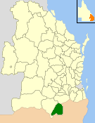
 Le comté de Stanthorpe en anglais : Shire of Stanthorpe est une ancienne zone d'administration locale situé dans l'État du Queensland en Australie, dont le siège était Stanthorpe. GéographieLe comté s'étendait sur 2 669 km2 dans l'extrémité sud du Queensland et comprenait la ville de Stanthorpe, ainsi que les localités d'Amiens, Applethorpe, Ballandean, Cottonvale, Dalcouth, Diamondvale, Eukey, Glen Aplin, Greenlands, Kyoomba, Lyra, Messines, Mingoola, Passchendaele, Pikedale, Pikes Creek, Pozieres, Severnlea, Somme, The Summit, Thorndale, Wallangarra et Wyberba. HistoireCréée en 1879, la division de Stanthorpe devient le comté du même nom le . Les comtés de Warwick et de Stanthorpe fusionnent le pour créer la région des Southern Downs. DémographieEn 2006, la population s'élevait à 10 124 habitants[1]. Références |
||||||||||||||||||||||||||||
Portal di Ensiklopedia Dunia
