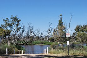
Wimmera River

Wimmera
The Wimmera River at Jeparit
Wimmera River is located in Victoria
Wimmera River
Location of the Wimmera River mouth in Victoria
Native nameWalla-walla, Wamara, Bunnut, Culcatok, Barbarton, Billiwhin, Wudjum-biat, Bar, Barengi-djul, Yaigir, Wudiyedi, Barrh, Tarnorrer, Barkar, Guri-beb, Giridji-gal, Wadidirabul, Maripmunninnera[1][2][3]
Location
CountryAustralia
StateVictoria
RegionMurray Darling Depression (IBRA), Wimmera
Local government areasArarat, Northern Grampians, Yarriambiack, Horsham, Hindmarsh
TownsElmhurst, Crowlands, Glenorchy, Horsham, Dimboola, Tarranyurk, Jeparit
Physical characteristics
SourcePyrenees, Great Dividing Range
 • locationbelow Ben Nevis, in a state forestry area south of Elmhurst
 • coordinates37°16′29″S 143°15′00″E / 37.27472°S 143.25000°E / -37.27472; 143.25000
 • elevation299 m (981 ft)
MouthLake Hindmarsh, Lake Albacutya
 • location
Outlook Creek, near Jeparit
 • coordinates
36°06′42″S 141°56′51″E / 36.11167°S 141.94750°E / -36.11167; 141.94750
 • elevation
79 m (259 ft)
Length278 km (173 mi)
Basin size24,011 km2 (9,271 sq mi)
Discharge 
 • average13 m3/s (460 cu ft/s)
Basin features
River systemWimmera catchment
Tributaries 
 • leftMount Cole Creek, Six Mile Creek (Wimmera), Seven Mile Creek (Wimmera), Concongella Creek, Sheepwash Creek, Mount William Creek, Mackenzie River, Burnt Creek, Darragan Creek, Norton Creek
 • rightGlenpatrick Creek, Glenlofty Creek, Spring Creek (Wimmera), Heifer Station Creek
National parksWyperfeld National Park, Little Desert National Park
[1][4]

The Wimmera River, an inland intermittent river of the Wimmera catchment, is located in the Grampians and Wimmera regions of the Australian state of Victoria. Rising in the Pyrenees, on the northern slopes of the Great Dividing Range, the Wimmera River flows generally north by west and drains into Lake Hindmarsh[5] and Lake Albacutya,[5] a series of ephemeral lakes that, whilst they do not directly empty into a defined watercourse, form part of the Murray River catchment of the Murray-Darling basin.

Course and features

The Wimmera River rises in the Great Dividing Range below Elmhurst, between Ararat and Avoca, and flows generally north and west, through Glenorchy, Horsham, Dimboola and Jeparit, also forming the eastern boundary of the Little Desert National Park. It is joined by fourteen minor tributaries, including the Mackenzie River, before reaching its mouth at Lake Hindmarsh, near Jeparit. The river descends 220 metres (720 ft) over its 278-kilometre (173 mi) course.[4]

On the rare occasions that Lake Hindmarsh overflows, water flows via Outlet Creek[5] to Lake Albacutya. In most years the flow of the river does not reach those terminal lakes, and the watercourse itself contracts into a series of pools.[6] On average, the lake fills once in twenty years.[7] The inflow of saline groundwater into the lower reaches of the river in recent years[when?] has severely affected its water quality, making the water more salty than sea water in several locations.

The river is crossed by the Pyrenees Highway near its source, the Henty Highway south of Horsham, and the Western Highway west of Horsham and, again, west of Dimboola.[4]

The Wimmera has a feature typical of desert drainage patterns in that it has distributaries, the Dunmunkle Creek and the Yarriambiack Creek, which divert water away from the Wimmera at times of high flow or flood.

Pipeline

The health of the Wimmera River was expected to improve following the Wimmera-Mallee pipeline project that was completed in 2008. The project involved replacing old, inefficient stock-water supply and irrigation infrastructure, with a pipeline system. Prior to the project's completion, up to 90 percent of water extracted from the Wimmera River was lost through evaporation and seepage. The Wimmera-Mallee Pipeline system was expected to be many times more efficient[citation needed] and meant that there would be much less water extracted from the Wimmera River. That was anticipated to reduce the quantities of water taken from the river and cause an increase in environmental flows in the river system.[citation needed]

Horsham flooding

Western Highway crossing the Wimmera River at Horsham

The Wimmera River at Horsham has been subject to periodic flooding, with peaks recorded as follows:

Flooding events on the Wimmera River, near Horsham
Flood peak Location(s) References
m ft Date
4.71 15.5 January 2011 (2011-01) [8]
3.87 12.7 October 1894 (1894-10) Dunmunkle and Yarriambiack creeks. Townships of Horsham, Glenorchy, Rupanyup, Warracknabeal, Dimboola and Jeparit affected.
3.87 12.7 August 1909 (1909-08) Dunmunkle and Yarriambiack creeks. Townships of Horsham, Glenorchy, Rupanyup, Warracknabeal, Dimboola and Jeparit affected.
3.73 12.2 September 1916 (1916-09) Townships of Glenorchy and Horsham affected.
3.55 11.6 August 1981 (1981-08) Flood affected the Wimmera River and Yarriambiack Creek.
3.49 11.5 October 1996 (1996-10)
3.32 10.9 September 2010 (2010-09) [9]
3.30 10.8 October 1992 (1992-10) [10]

Etymology

In the Aboriginal Djadjawurrung and Jardwadjali languages the river is named Walla-walla, with no defined meaning; and Wamara, possibly meaning woomera or "throwing stick". In the Jardwadjali language the river is named Bunnut, with the Bernett people a clan of the Jardwadjali people; and Barbarton, with bar meaning "river" and the Barbardinbalug were a Jardwadjali clan centred on the Wimmera River. In the Djadjawurrung language the river is named Culcatok, with no defined meaning. In the Djabwurrung, Jardwadjali, and Wergaia languages, the river is named Billiwhin, with no defined meaning. In the Wergaia language the river has several names including Wudjum-bial, with bial meaning red gum; Barengi-djul, with bareng meaning "river" and djul meaning waterbags; Yaigir, with no defined meaning; Wudiyedi, with no defined meaning; Guri-beb, with beb meaning white gum; Giridji-gal, with a meaning that "a dog was always there"; Wadidirabul, with no defined meaning. In the Djabwurrung language the river has several names including Bar and Barkar, with bar meaning "river"; and Tarnorrer and Maripmunninnera, both with no defined meaning. In an undefined local Aboriginal language, the river is named Barrh, with no defined meaning.[1][2][3]

The colonial name of the river is derived from the name of the pastoral run. Gold was discovered in the river in 1866.[11]

See also

References

  1. ^ a b c "Wimmera River (entry 622167)". VICNAMES. Government of Victoria. Retrieved 23 October 2014.
  2. ^ a b Smyth, Robert Brough (1878). The Aborigines of Victoria. Melbourne: Victorian Government Printer. p. 176. OL 23539869M.
  3. ^ a b Clark, Ian; Heydon, Toby (2011). "Wimmera River: Traditional Names". Victorian Aboriginal Corporation for Languages.
  4. ^ a b c "Map of Wimmera River, VIC". Bonzle Digital Atlas of Australia. Retrieved 23 October 2014.
  5. ^ a b c Griffin, Darren; Muir, Ben. "Barringgi Gadyin – The Wimmera River and Wotjobaluk Connection to Country" (PDF). biolinksalliance.org.au. Retrieved 17 October 2021.
  6. ^ Ker, Peter (25 January 2011). "Parched lake may end 15-year dry". The Age. Retrieved 15 February 2019.
  7. ^ "Lake Albacutya Park". Parks Victoria. Retrieved 15 February 2019.
  8. ^ "Floodwaters affecting the North West". The Age. Melbourne. 18 January 2011.
  9. ^ "Flood Update" (streaming audio). ABC Radio. Horsham, Victoria, Australia. 9 September 2010.
  10. ^ "Horsham Floods". Wimmera Catchment Management Authority. Victorian Government.
  11. ^ Sinnott, Nigel. Place-Names of the Alexandra, Lake Eildon and Big River Area of Victoria. Alexandra: Friends of the Alexandra Library.


Index: pl ar de en es fr it arz nl ja pt ceb sv uk vi war zh ru af ast az bg zh-min-nan bn be ca cs cy da et el eo eu fa gl ko hi hr id he ka la lv lt hu mk ms min no nn ce uz kk ro simple sk sl sr sh fi ta tt th tg azb tr ur zh-yue hy my ace als am an hyw ban bjn map-bms ba be-tarask bcl bpy bar bs br cv nv eml hif fo fy ga gd gu hak ha hsb io ig ilo ia ie os is jv kn ht ku ckb ky mrj lb lij li lmo mai mg ml zh-classical mr xmf mzn cdo mn nap new ne frr oc mhr or as pa pnb ps pms nds crh qu sa sah sco sq scn si sd szl su sw tl shn te bug vec vo wa wuu yi yo diq bat-smg zu lad kbd ang smn ab roa-rup frp arc gn av ay bh bi bo bxr cbk-zam co za dag ary se pdc dv dsb myv ext fur gv gag inh ki glk gan guw xal haw rw kbp pam csb kw km kv koi kg gom ks gcr lo lbe ltg lez nia ln jbo lg mt mi tw mwl mdf mnw nqo fj nah na nds-nl nrm nov om pi pag pap pfl pcd krc kaa ksh rm rue sm sat sc trv stq nso sn cu so srn kab roa-tara tet tpi to chr tum tk tyv udm ug vep fiu-vro vls wo xh zea ty ak bm ch ny ee ff got iu ik kl mad cr pih ami pwn pnt dz rmy rn sg st tn ss ti din chy ts kcg ve 
Prefix: a b c d e f g h i j k l m n o p q r s t u v w x y z 0 1 2 3 4 5 6 7 8 9