|
Warren, Oregon
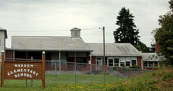
Warren is an unincorporated community and census-designated place in Columbia County, Oregon, United States, located on U.S. Route 30 north of Scappoose and south of St. Helens on Scappoose Bay of the Multnomah Channel. As of the 2010 census it had a population of 1,787.[4] The Warren post office was established in 1885; it was named by local resident James Gill for his hometown of Warren, Massachusetts.[5] The post office was discontinued in 1888, but reestablished in 1890 as "Gilltown" because there was another post office named Warren in Umatilla County.[5] The Columbia County office became Warren again in 1895, and the Umatilla County office was closed in 1902; the locality in Umatilla County is now known as Myrick.[5] Demographics
As of the 2020 census, there were 1,870 people, 782 families, and 741 housing units.[7] In the city, there were 1,683 White people, 11 African Americans, 22 Native Americans, 12 Asians, 3 Pacific Islanders, 10 people who said they were from another race, and 129 who were from two or more races. 86 people were of Hispanic or Latino origin.[7] The ancestry of Warren, Oregon was 25.5% German, 10.7% English,8.5% Irish, 8.2% Norwegian, 7.5% Scottish, 2.7% Italian, 2.3% Polish, and 1.8% French.[7] The median age in Warren was 59.9 years old. With 37.6% of the population being over 65, 22.4% were from 65 to 74, 14.3% 75 to 84, and 0.9% were older than 85. 1.4% of the population were foreign born.[7] The median household income was $88,409. For families it was $104,196, for married-couple families it was the same, and for non-families it was $42,205. 1.8% of the population were in poverty. 5.3% of people under 18 were in poverty, 2.1% of people 18 to 64 years old were in poverty, and 0.0% of people over 65 were in poverty.[7] ClimateThis region experiences warm (but not hot) and dry summers, with no average monthly temperatures above 71.6 °F (22.0 °C). According to the Köppen Climate Classification system, Warren has a warm-summer Mediterranean climate, abbreviated "Csb" on climate maps.[8] References
|
||||||||||||||||||||||||||||||||||||||||||||||||||||||
Portal di Ensiklopedia Dunia


