|
Tomika, Gifu
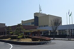
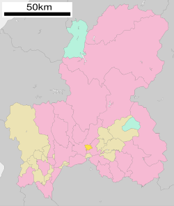
 Tomika (富加町, Tomika-chō) is a town located in Kamo District, Gifu Prefecture, Japan. As of 31 December 2018[update], the town had an estimated population of 5,714 and a population density of 340 persons per km2, in 1962 households.[1] The total area of the town was 57.09 square kilometres (22.04 sq mi). GeographyTomika is located in south-central Gifu Prefecture. The city is bordered by Seki to the west and Minokamo to the east. Mount Nashiwari is within the town's boundaries. The Kawaura and Tsubo Rivers flow through the town. The town has a climate characterized by characterized by hot and humid summers, and mild winters (Köppen climate classification Cfa). The average annual temperature in Tomika is 15.1 °C. The average annual rainfall is 2074 mm with September as the wettest month. The temperatures are highest on average in August, at around 27.8 °C, and lowest in January, at around 3.3 °C.[2] Neighbouring municipalitiesDemographicsPer Japanese census data,[3] the population of Tomika has remained relatively steady over the past 50 years.
HistoryThe area around Tomika was part of traditional Mino Province. During the Edo period, the area was tenryō territory controlled directly by the Tokugawa shogunate. With the post Meiji restoration cadastral reforms, Kamo District within Gifu Prefecture was created, and the village of Tomida was established on April 1, 1897. Tomida merged with the village of Kajita on July 1, 1954, forming the village of Tomika (taking its name from Tomida (富田) and Kajita (加冶田) Tomika was elevated to town status on July 1, 1974. A referendum to merge into the city of Minokamo, was defeated in 2004. EducationTomika has one public elementary school operated by the town government, and one public junior high school operated jointly between Tomika and neighbouring Minokamo. The town does not have a high school. TransportationRailwayHighwayReferencesExternal links
|
|||||||||||||||||||||||||||||||||||||||||||||||||||||||||||||||||||||
Portal di Ensiklopedia Dunia


