Tetonia, Idaho

Tetonia, Idaho
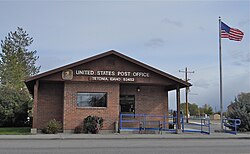
Tetonia Post Office, October 2013
Location of Tetonia in Teton County, Idaho.
Coordinates: 43°48′52″N 111°09′31″W / 43.81444°N 111.15861°W / 43.81444; -111.15861[1]
CountryUnited States
StateIdaho
CountyTeton
Area
 • Total
0.57 sq mi (1.47 km2)
 • Land0.57 sq mi (1.47 km2)
 • Water0.00 sq mi (0.00 km2)
Elevation6,067 ft (1,849 m)
Population
 • Total
269
 • Estimate 
(2019)[4]
288
 • Density507.04/sq mi (195.61/km2)
Time zoneUTC-7 (Mountain (MST))
 • Summer (DST)UTC-6 (MDT)
ZIP codes
83424, 83452
Area code(s)208, 986
FIPS code16-80470
GNIS feature ID2412053[1]
Websitetetoniaidaho.com

Tetonia is a city in Teton County, Idaho, United States, about 50 miles (80 km) northeast of Idaho Falls, Idaho (center to center) and about 425 miles (684 km) northwest of Denver, Colorado. The population was 269 at the 2010 census.

Geography

According to the United States Census Bureau, the city has a total area of 0.57 square miles (1.48 km2), all land.[5] Tetonia is located at 43°48′50″N 111°9′35″W, in Teton County Idaho.

Climate

According to the Köppen Climate Classification system, Tetonia has a warm-summer humid continental climate, abbreviated "Dfb" on climate maps. The hottest temperature recorded in Tetonia was 98 °F (36.7 °C) on July 15, 1955, while the coldest temperature recorded was −57 °F (−49.4 °C) on February 9, 1933.[6]

Climate data for Tetonia, Idaho, 1991–2020 normals, extremes 1952–present
Month Jan Feb Mar Apr May Jun Jul Aug Sep Oct Nov Dec Year
Record high °F (°C) 59
(15)
60
(16)
66
(19)
79
(26)
88
(31)
91
(33)
98
(37)
97
(36)
93
(34)
83
(28)
67
(19)
57
(14)
98
(37)
Mean maximum °F (°C) 40.8
(4.9)
43.9
(6.6)
53.5
(11.9)
67.1
(19.5)
75.8
(24.3)
83.4
(28.6)
88.1
(31.2)
87.6
(30.9)
84.0
(28.9)
73.7
(23.2)
56.9
(13.8)
43.8
(6.6)
89.1
(31.7)
Mean daily maximum °F (°C) 26.8
(−2.9)
30.7
(−0.7)
39.2
(4.0)
49.1
(9.5)
60.2
(15.7)
68.7
(20.4)
78.1
(25.6)
78.2
(25.7)
68.8
(20.4)
54.0
(12.2)
38.1
(3.4)
26.9
(−2.8)
51.6
(10.9)
Daily mean °F (°C) 17.5
(−8.1)
20.7
(−6.3)
29.1
(−1.6)
38.0
(3.3)
47.4
(8.6)
54.7
(12.6)
62.6
(17.0)
61.8
(16.6)
53.3
(11.8)
40.8
(4.9)
28.4
(−2.0)
18.1
(−7.7)
39.4
(4.1)
Mean daily minimum °F (°C) 8.2
(−13.2)
10.7
(−11.8)
19.0
(−7.2)
26.9
(−2.8)
34.7
(1.5)
40.7
(4.8)
47.1
(8.4)
45.4
(7.4)
37.7
(3.2)
27.6
(−2.4)
18.7
(−7.4)
9.3
(−12.6)
27.2
(−2.7)
Mean minimum °F (°C) −14.8
(−26.0)
−10.7
(−23.7)
−0.9
(−18.3)
12.5
(−10.8)
22.4
(−5.3)
30.0
(−1.1)
36.8
(2.7)
34.1
(1.2)
24.3
(−4.3)
11.6
(−11.3)
−1.4
(−18.6)
−13.1
(−25.1)
−19.7
(−28.7)
Record low °F (°C) −39
(−39)
−57
(−49)
−20
(−29)
−7
(−22)
7
(−14)
19
(−7)
28
(−2)
22
(−6)
6
(−14)
−8
(−22)
−23
(−31)
−45
(−43)
−57
(−49)
Average precipitation inches (mm) 2.03
(52)
1.16
(29)
1.56
(40)
1.78
(45)
2.30
(58)
1.69
(43)
0.88
(22)
1.19
(30)
1.50
(38)
1.61
(41)
1.19
(30)
2.07
(53)
18.96
(481)
Average precipitation days (≥ 0.01 in) 10.8 8.3 7.3 9.0 10.0 8.1 5.0 5.7 5.7 7.2 8.3 10.8 96.2
Source 1: NOAA[7]
Source 2: National Weather Service[6]

History

Tetonia was established as an agricultural town in the late 19th century, taking its name from the nearby Teton Range.[8] Many of the businesses previously operating in Haden relocated to Tetonia following the arrival of the Union Pacific railroad.[9]

Demographics

Historical population
CensusPop.Note
1950232
1960194−16.4%
1970176−9.3%
19801918.5%
1990132−30.9%
200024787.1%
20102698.9%
2019 (est.)288[4]7.1%
U.S. Decennial Census[10]

2010 census

As of the census[3] of 2010, there were 269 people, 95 households, and 62 families residing in the city. The population density was 471.9 inhabitants per square mile (182.2/km2). There were 122 housing units at an average density of 214.0 per square mile (82.6/km2). The racial makeup of the city was 92.2% White, 0.7% Native American, 6.3% from other races, and 0.7% from two or more races. Hispanic or Latino of any race were 10.8% of the population.

There were 95 households, of which 46.3% had children under the age of 18 living with them, 49.5% were married couples living together, 11.6% had a female householder with no husband present, 4.2% had a male householder with no wife present, and 34.7% were non-families. 28.4% of all households were made up of individuals, and 10.5% had someone living alone who was 65 years of age or older. The average household size was 2.83 and the average family size was 3.61.

The median age in the city was 35.1 years. 36.1% of residents were under the age of 18; 5.1% were between the ages of 18 and 24; 26.7% were from 25 to 44; 24.5% were from 45 to 64; and 7.4% were 65 years of age or older. The gender makeup of the city was 48.7% male and 51.3% female.

Education

Teton County School District #401 is the single school district in the county.[11] Teton High School is the county's sole comprehensive high school.

College of Eastern Idaho includes this county in its catchment zone; however this county is not in its taxation zone.[12]

See also

References

  1. ^ a b c U.S. Geological Survey Geographic Names Information System: Tetonia, Idaho
  2. ^ "2019 U.S. Gazetteer Files". United States Census Bureau. Retrieved July 9, 2020.
  3. ^ a b "U.S. Census website". United States Census Bureau. Retrieved December 18, 2012.
  4. ^ a b "Population and Housing Unit Estimates". United States Census Bureau. May 24, 2020. Retrieved May 27, 2020.
  5. ^ "US Gazetteer files 2010". United States Census Bureau. Archived from the original on January 25, 2012. Retrieved December 18, 2012.
  6. ^ a b "NOAA Online Weather Data – NWS Pocatello". National Weather Service. Retrieved July 7, 2023.
  7. ^ "U.S. Climate Normals Quick Access – Station: Tetonia EXP STN, ID". National Oceanic and Atmospheric Administration. Retrieved July 7, 2023.
  8. ^ "Tetonia–Spotlight | IDAHO magazine".
  9. ^ "GNIS Detail - Haden (Historical)".
  10. ^ "Census of Population and Housing". Census.gov. Retrieved June 4, 2015.
  11. ^ "2020 CENSUS - SCHOOL DISTRICT REFERENCE MAP: Teton County, ID" (PDF). United States Census Bureau. Retrieved March 12, 2024. - Text list
  12. ^ "Community Colleges" (PDF). Budget Hearing. Idaho Legislature. 2020. p. 1-73 (PDF p. 8/14). Retrieved March 12, 2024.


Prefix: a b c d e f g h i j k l m n o p q r s t u v w x y z 0 1 2 3 4 5 6 7 8 9

Portal di Ensiklopedia Dunia