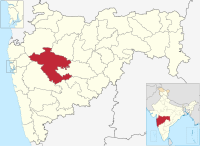
Shevgaon taluka

Shevgaon taluka
Location of Shevgaon in Ahmednagar district in Maharashtra
Country India
StateMaharashtra
DistrictAhmednagar district
HeadquartersAhmednagar
Area
 • Total
1,031.85 km2 (398.40 sq mi)
Population
 (2011)
 • Total
245,714
 • Density240/km2 (620/sq mi)

Shevgaon taluka is a taluka in Ahmednagar subdivision of Ahmednagar district in Maharashtra state of India.[1]

Area

The table below shows area of the taluka by land type.[2]

Type of Land Area (km2) % of Total Area
Agriculture 913.19 88.5
Forest 11.57 1.12
Other 107.09 10.38
Total 1031.85 100

Villages

There are around 112 villages in Shevgaon taluka. For list of villages see Villages in Shevgaon taluka.

Population

Religions in Shevgaon taluk (2011)[3]
Religion Percent
Hinduism
90.65%
Islam
7.93%
Buddhism
0.42%
Other or not stated
1.00%

Shevgaon taluka has a population of 245,714 according to the 2011 census. Shevgaon had a literacy rate of 73.94% and a sex ratio of 953 females per 1000 males. The entire population lives in rural areas. Scheduled Castes and Scheduled Tribes make up 14.72% and 1.91% of the population respectively.[4]

Languages of Shevgaon taluk (2011)[5]

  Marathi (89.88%)
  Hindi (4.41%)
  Urdu (3.30%)
  Vadari (0.98%)
  Others (1.43%)

At the time of the 2011 Census of India, 89.88% of the population in the district spoke Marathi, 4.41% Hindi, 3.30% Urdu and 0.98% Vadari as their first language.[5]

Rain Fall

The table below details rainfall from 1981 to 2004.[6]

Year Rainfall (mm)
1981 - 1982 407
1983 563
1984 309
1985 247
1986 422
1987 596
1988 824
1989 730
1990 697
1991 391
1992 369
1993 519
1994 584.6
1995 363
1996 782
1997 226
1998 780
1999 366
2000 531
2001 349
2002 449
2003 320
2004 715

See also

095270 44983 https://www.google.com/maps?cid=10184565873800887938)

References

  1. ^ Talukas in Ahmednagar district
  2. ^ Talukas geographic information
  3. ^ "Table C-01 Population by Religion: Maharashtra". censusindia.gov.in. Registrar General and Census Commissioner of India. 2011.
  4. ^ "District Census Hand Book – Ahmednagar" (PDF). Census of India. Registrar General and Census Commissioner of India.
  5. ^ a b "Table C-16 Population by Mother Tongue: Maharashtra". censusindia.gov.in. Registrar General and Census Commissioner of India.
  6. ^ Rainfall information of Ahemadnagar district


Prefix: a b c d e f g h i j k l m n o p q r s t u v w x y z 0 1 2 3 4 5 6 7 8 9

Portal di Ensiklopedia Dunia