Pertek

Pertek
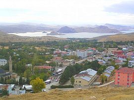
View of Pertek, the 16th century Celebi Ali mosque is visible in the left of the image. Lake Keban is in the background.
Pertek is located in Turkey
Pertek
Pertek
Location in Turkey
Coordinates: 38°52′01″N 39°19′30″E / 38.86694°N 39.32500°E / 38.86694; 39.32500
CountryTurkey
ProvinceTunceli
DistrictPertek
Government
 • MayorRecai Vural (AKP)
Population
 (2021)
6,365
Time zoneUTC+3 (TRT)
Websitewww.pertek.bel.tr

Pertek (Armenian: Բերդակ, romanizedBerdak; Kurdish: Pêrteg)[1] is a town and seat of Pertek District in Tunceli Province, Turkey.[2] It had a population of 6,365 in 2021 and is populated by Kurds and Turks.[3][4] The mayor is Recai Vural from the Justice and Development Party (Turkey) (AKP).[5]

The neighborhoods of the town are Camiikebir, Derebaşı, İstiklal, Kaledibi, Soğukpınar.[2]

History

The area of Pertek was ruled by different empires in its history. In the medieval period such as the Armenians and Byzantines before being taken over by different Islamic dynasties after the 11th century. Later it became part of the Ilkhanids and others and finally became part of the Ottoman Empire in the early 16th century.

During the Ottoman period Pertek was a hereditary Kurdish sanjak.[6] The old town of Pertek (Eski Pertek) was located near the citadel but was abandoned in 1838 and moved to its current location.[6] Armenian sources state that about 180 Armenians still lived in the old town (Eski Pertek) up until the early 1900s despite the rising water levels of the Euphrates river.[7] After 1889, it was fully incorporated into the Mamuretul-aziz Vilayet as a nahiye district of the Charsanjak kaza within the sanjak of Dersim.[8]

According to the 1881 Ottoman census, there were 6 neighborhoods of Pertag town - 1154 total males (966 Muslim, 188 Armenian Apostolic) in 520 households. The general district had 23 villages of Pertag district - 127 total males (943 Muslim, 184 Armenian Apostolic) in 552 households. Females were often undercounted or entirely disregarded from census counts.[7]

As a result of the construction of the Keban Dam, the Pertek district experienced the submerging of a number of its district's villages. Some of the settlements submerged were Eski Pertek, Borkin, Korluca (Til), Balan, Deşt, Zahuran, Beroç, Karameşe (Tezikan) [partially submerged], Tuzbaşı (Nisirto) [abandoned].[9]

Historic monuments

There are two historic Ottoman mosques in Pertek.[6] The Baysungur mosque (16th century)[6] and Celebi Ali mosque (16th century).[6] The mosques were later dismantled and moved from the site of the old town to protect them from the rising water shore of the Lake Keban.[6] The Pertek Castle is located on an Island.[6] There are other historic sights in the nearby area. The village of Sağman has a ruined citadel with a 16th-century mosque, tomb and tekke built by the Kurdish sanjak bey Keykusrav.[6]

Archaeology

In August 2022, archaeologists led by Kenan Öncel announced that they had discovered a child skeleton in an oval-shaped pit in Tozkoparan Mound. They also revealed terracotta potteries, obsidians, bones, stone tools and arrowheads. In order to determine the skeleton's diet and age-at-death, researchers are planning to trace the diseases left in the bones.[10][11]

References

  1. ^ Avcıkıran, Adem (2009). Kürtçe Anamnez Anamneza bi Kurmancî (in Turkish and Kurdish). p. 55.
  2. ^ a b "Türkiye Mülki İdare Bölümleri Envanteri". T.C. İçişleri Bakanlığı (in Turkish). Retrieved 19 December 2022.
  3. ^ "Address-based population registration system (ADNKS) results dated 31 December 2021" (XLS) (in Turkish). TÜİK. Retrieved 30 January 2023.
  4. ^ Andrews, Peter; Benninghaus, Rüdiger (2002). Ethnic Groups in the Republic of Turkey: Supplement and Index. p. 64. ISBN 9783895002298.
  5. ^ Şafak, Yeni (2019-06-12). "Tunceli Pertek Seçim Sonuçları – Pertek Yerel Seçim Sonuçları". Yeni Şafak (in Turkish). Retrieved 2019-12-06.
  6. ^ a b c d e f g h Sinclair, T.A. (1989). Eastern Turkey: An Architectural & Archaeological Survey, Volume I. Pindar Press. pp. 77–83–84–85–102–103–158. ISBN 9780907132325.
  7. ^ a b "Maps | Vilayet of Mamuratul Aziz-Harput | Sandjak of Dersim | Locale | Demography (Part III) :: Houshamadyan - a project to reconstruct Ottoman Armenian town and village life".
  8. ^ Sezen, Tahir. 2017. Osmanlı yer adları.
  9. ^ "Keban barajı ile neler kaybettik?" (PDF). Archived from the original (PDF) on 11 August 2021. Retrieved 11 August 2021.
  10. ^ "Child skeleton among findings in Tunceli excavations". Hürriyet Daily News. Retrieved 2022-08-11.
  11. ^ YILDIRIM/TUNCELİ, (DHA), Serhat Ozan. "Tunceli'de kazı çalışmasında bulundu: 5 bin 500 yıllık..." www.hurriyet.com.tr (in Turkish). Retrieved 2022-08-11.


Index: pl ar de en es fr it arz nl ja pt ceb sv uk vi war zh ru af ast az bg zh-min-nan bn be ca cs cy da et el eo eu fa gl ko hi hr id he ka la lv lt hu mk ms min no nn ce uz kk ro simple sk sl sr sh fi ta tt th tg azb tr ur zh-yue hy my ace als am an hyw ban bjn map-bms ba be-tarask bcl bpy bar bs br cv nv eml hif fo fy ga gd gu hak ha hsb io ig ilo ia ie os is jv kn ht ku ckb ky mrj lb lij li lmo mai mg ml zh-classical mr xmf mzn cdo mn nap new ne frr oc mhr or as pa pnb ps pms nds crh qu sa sah sco sq scn si sd szl su sw tl shn te bug vec vo wa wuu yi yo diq bat-smg zu lad kbd ang smn ab roa-rup frp arc gn av ay bh bi bo bxr cbk-zam co za dag ary se pdc dv dsb myv ext fur gv gag inh ki glk gan guw xal haw rw kbp pam csb kw km kv koi kg gom ks gcr lo lbe ltg lez nia ln jbo lg mt mi tw mwl mdf mnw nqo fj nah na nds-nl nrm nov om pi pag pap pfl pcd krc kaa ksh rm rue sm sat sc trv stq nso sn cu so srn kab roa-tara tet tpi to chr tum tk tyv udm ug vep fiu-vro vls wo xh zea ty ak bm ch ny ee ff got iu ik kl mad cr pih ami pwn pnt dz rmy rn sg st tn ss ti din chy ts kcg ve 
Prefix: a b c d e f g h i j k l m n o p q r s t u v w x y z 0 1 2 3 4 5 6 7 8 9