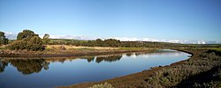
Onkaparinga River

Onkaparinga
Onkaparinga River estuary
Onkaparinga River is located in South Australia
Onkaparinga River
Location of the river mouth in South Australia
Native nameNgangkiparri (Kaurna)
Location
CountryAustralia
StateSouth Australia
RegionSouthern Adelaide
Local government areaCity of Onkaparinga
TownsWoodside, Oakbank, Clarendon
Physical characteristics
SourceMount Lofty Range
 • locationbetween Charleston and Mount Torrens
 • elevation422 m (1,385 ft)
MouthGulf St Vincent
 • location
between Port Noarlunga South and Port Noarlunga
 • coordinates
35°09′53″S 138°28′10″E / 35.164660°S 138.469520°E / -35.164660; 138.469520
 • elevation
0 m (0 ft)
Length88 km (55 mi)
Basin size562 km2 (217 sq mi)
Basin features
Protected areasEncounter Marine Park
Onkaparinga River National Park
Onkaparinga River Recreation Park
Port Noarlunga Reef Aquatic Reserve
[1][2][3][4]

The Onkaparinga River, known as Ngangkiparri or Ngangkiparingga ("place of the women’s river") in the Kaurna language, is a river located in the Southern Adelaide region in the Australian state of South Australia. Rising in the Mount Lofty Ranges, the river's estuary extends from Old Noarlunga to the river's mouth between the suburbs of Port Noarlunga and Port Noarlunga South.

Etymology and history

The name derives from the language of the Kaurna people, a word written as either Ngangkiparri or Ngangkiparingga (the -ngga suffix means "at"). Translated, it means "place of the women’s river".[5]

Bridge over the Onkaparinga at Clarendon circa 1869

On 13 April 1831, British military officer Captain Collet Barker and his party arrived at Cape Jervis on the Isabella. He examined the east coast of Gulf St Vincent and found the Onkaparinga River on 15 April. After anchoring and heading inland Barker then explored the ranges inland, north of the present site of Adelaide, and climbed Mount Lofty where he also sighted the Port River inlet, Barker Inlet and the future Port Adelaide.[6]

In 1837 Surveyor-General of South Australia Colonel William Light named it Field's River, or the Field River, after Lieutenant William George Field RN (1804–1850) of the brig Rapid (one of the "first fleet"), who carried out the first surveys in the vicinity of its estuary, but subsequent Governor George Gawler soon reinstated the Indigenous name.[7]

The first European settlers to explore its sources and the Onkaparinga Valley were the party of George Imlay and John Hill in January 1838.[7]

Course and features

The Onkaparinga River rises on the slopes of the Mount Lofty Range between Mount Torrens and Charleston and flows generally southwesterly, south of the Adelaide city centre, to reach its mouth at Port Noarlunga. The catchment area is over 500 square kilometres (190 square miles) in area, and in part includes the protected areas of the Encounter Marine Park, the Onkaparinga River National Park, the Onkaparinga River Recreation Park and the Port Noarlunga Reef Aquatic Reserve.[8][9][10] The river descends 422 metres (1,385 ft) over its 88-kilometre (55 mi) course.[4]

Onkaparinga Estuary on winter afternoon at Noarlunga Downs, facing east

The Onkaparinga River is the second major river within the Adelaide metropolitan area, after the River Torrens. It is a source of fresh water for Adelaide. Mount Bold Reservoir was constructed between 1932 and 1938 along a section of its path approximately 20 kilometres (12 miles) inland. Much of its flow is diverted via a tunnel from the Clarendon Weir to the Happy Valley Reservoir, that in turn supplies some 40 per cent of Adelaide's water supply. Most years the flow to the reservoir is supplemented by water pumped from the River Murray via a pipeline from Murray Bridge.

Downstream from Mount Bold Reservoir is the Clarendon Weir. To maintain levels at Clarendon Weir, water is released only as required. The Onkaparinga Gorge extends from Clarendon to Old Noarlunga. An estuary extends from Old Noarlunga to the river's mouth between the suburbs of Port Noarlunga and Port Noarlunga South. The estuary is a significant breeding area for local marine fish species.

Onkaparinga at Clarendon Weir

The Coast to Vines rail trail crosses over the river just west of where Main South Road crosses over. The Seaford railway line passes over the river on a 1.2-kilometre (0.75 mi) elevated bridge (known as the Onkaparinga Valley Bridge) which was built between 2011 and 2014.[11]

See also

References

  1. ^ "GEOGRAPHICAL NAMES ACT, 1991, Notice of Declaration of Names of Places" (PDF). The South Australian Government Gazette. Government of South Australia: 342. 3 February 2011. Retrieved 30 March 2017.
  2. ^ "Search result for "Onkaparinga River, Strm" with the following layers selected – " Prescribed Water Courses", "Local Government Areas", and " SA Government Regions"". Location SA Map Viewer. Government of South Australia. Retrieved 30 March 2017.
  3. ^ "Search result for "Onkaparinga River (STRM)" (Record no SA0052262) with the following layers selected – "Suburbs and Localities", "Place names (gazetteer)" and "Road Labels"". Property Location Browser. Government of South Australia. Archived from the original on 12 October 2016. Retrieved 30 March 2017.
  4. ^ a b "Map of Onkaparinga River, SA". Bonzle Digital Atlas of Australia. Retrieved 25 March 2017.
  5. ^ Schultz, Chester (4 August 2017). "Ngangki-Paringga". Adelaide Research & Scholarship. Retrieved 16 November 2020.
  6. ^ "SA Memory".
  7. ^ a b "SOUTH AUSTRALIA". The Colonist. Vol. IV, no. 176. New South Wales, Australia. 7 March 1838. p. 2. Retrieved 16 November 2020 – via National Library of Australia.
  8. ^ "Aquatic Reserves And Marine Parks – Port Noarlunga" (PDF). PIRSA Fisheries. Archived from the original (PDF) on 31 March 2012. Retrieved 31 October 2012.
  9. ^ "MARINE PARK 15, Encounter" (PDF). Department of Environment, Water and Natural Resources. Retrieved 5 November 2014.
  10. ^ "Management Plan – Onkaparinga River Reserve" (PDF). Department of Environment and Heritage. 2004. p. 5. Retrieved 3 April 2014.
  11. ^ "Seaford rail extension bridges" (PDF). Department of Transport Energy and Infrastructure. Retrieved 4 April 2014.

Further reading


Index: pl ar de en es fr it arz nl ja pt ceb sv uk vi war zh ru af ast az bg zh-min-nan bn be ca cs cy da et el eo eu fa gl ko hi hr id he ka la lv lt hu mk ms min no nn ce uz kk ro simple sk sl sr sh fi ta tt th tg azb tr ur zh-yue hy my ace als am an hyw ban bjn map-bms ba be-tarask bcl bpy bar bs br cv nv eml hif fo fy ga gd gu hak ha hsb io ig ilo ia ie os is jv kn ht ku ckb ky mrj lb lij li lmo mai mg ml zh-classical mr xmf mzn cdo mn nap new ne frr oc mhr or as pa pnb ps pms nds crh qu sa sah sco sq scn si sd szl su sw tl shn te bug vec vo wa wuu yi yo diq bat-smg zu lad kbd ang smn ab roa-rup frp arc gn av ay bh bi bo bxr cbk-zam co za dag ary se pdc dv dsb myv ext fur gv gag inh ki glk gan guw xal haw rw kbp pam csb kw km kv koi kg gom ks gcr lo lbe ltg lez nia ln jbo lg mt mi tw mwl mdf mnw nqo fj nah na nds-nl nrm nov om pi pag pap pfl pcd krc kaa ksh rm rue sm sat sc trv stq nso sn cu so srn kab roa-tara tet tpi to chr tum tk tyv udm ug vep fiu-vro vls wo xh zea ty ak bm ch ny ee ff got iu ik kl mad cr pih ami pwn pnt dz rmy rn sg st tn ss ti din chy ts kcg ve 
Prefix: a b c d e f g h i j k l m n o p q r s t u v w x y z 0 1 2 3 4 5 6 7 8 9