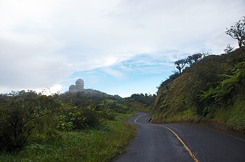
Naguabo, Puerto Rico

Naguabo
Municipio Autónomo de Naguabo
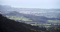
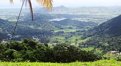
View of Naguabo from El Yunque
Flag of Naguabo
Coat of arms of Naguabo
Nicknames: 
"Cuna de Grandes Artistas", "Los Enchumbaos"
Anthem: "Mi Naguabo del querer, Mi Naguabo del soñar"
Map of Puerto Rico highlighting Naguabo Municipality
Coordinates: 18°13′10″N 65°44′12″W / 18.21944°N 65.73667°W / 18.21944; -65.73667
Sovereign state United States
Commonwealth Puerto Rico
FoundedJuly 15, 1821
Barrios
Government
 • MayorMiraidaliz Rosario Pagán (PPD)
 • Senatorial dist.7 - Humacao
 • Representative dist.35
Area
 • Total60.1 sq mi (155.57 km2)
 • Land52.1 sq mi (135 km2)
 • Water7.9 sq mi (20.57 km2)
Population
 (2020)
 • Total23,386
 • Rank52nd in Puerto Rico
 • Density390/sq mi (150/km2)
DemonymNaguabeños
Time zoneUTC−4 (AST)
ZIP Codes
00718, 00744
Area code787/939
Major routes

Naguabo (Spanish pronunciation: [naˈɣwaβo], locally [naˈwaβo]) is a town and municipality in Puerto Rico located in the east coast of the island bordered by the Vieques Passage, north of Humacao; south of Río Grande and Ceiba; and east of Las Piedras. Naguabo is spread over 8 barrios and Naguabo Pueblo (the downtown area and the administrative center of the city). It is part of the San Juan-Caguas-Guaynabo Metropolitan Statistical Area.

Naguabo is renowned for and is said to be the birthplace of the pastelillo de chapín, which is a popular food in Puerto Rico. It is trunkfish wrapped inside deep-fried flour dough. Pastelillos de chapín can be found in almost any seaside establishment on the island.

History

The town of Naguabo was founded near a ravine on the east coast and relocated in 1821 to its current location. In 1878, Naguabo had the following barrios: Pueblo, Maizales, Duque, Mariana, Quebrada Palma, Daguao, Santiago y Lima, Húcares, Río, Peña Pobre and Río Blanco. In 1521, Daguao was burned down by Caribs.[1][2][3]

Puerto Rico was ceded by Spain in the aftermath of the Spanish–American War under the terms of the Treaty of Paris of 1898 and became a territory of the United States. In 1899, the United States Department of War conducted a census of Puerto Rico finding that the population of Naguabo was 10,873.

On September 20, 2017, Hurricane Maria struck Puerto Rico. In Naguabo, sector Playa Húcares on the coast was the most affected with most homes destroyed or losing the roof. The boardwalk was destroyed and over 6,000 people reported losses.[4]

Geography

Naguabo is located in the southeast region of Puerto Rico. The highest point in the municipality is Pico del Este in the Sierra de Luquillo at 3,419 feet (1,042 m) of elevation.[5][6][7]

Río Blanco and Río Espiritu Santo are located in Naguabo.[8]

Barrios

Subdivisions of Naguabo.

Like all municipalities of Puerto Rico, Naguabo is subdivided into barrios. The municipal buildings, central square and large Catholic church are located in a barrio referred to as "el pueblo".[9][10][11][12]

Sectors

Barrios (which are, in contemporary times, roughly comparable to minor civil divisions)[13] and subbarrios,[14] are further subdivided into smaller areas called sectores (sectors in English). The types of sectores may vary, from normally sector to urbanización to reparto to barriada to residencial, among others.[15][16][17]

Special Communities

Comunidades Especiales de Puerto Rico (Special Communities of Puerto Rico) are marginalized communities whose citizens are experiencing a certain amount of social exclusion. A map shows these communities occur in nearly every municipality of the commonwealth. Of the 742 places that were on the list in 2014, the following barrios, communities, sectors, or neighborhoods were in Naguabo: Relámpago neighborhood, Río, Santiago y Lima, Daguao, La Florida, Casco Urbano in barrio-pueblo, Húcares, Maizales, Parcelas La Fe, and Río Blanco.[18]

Demographics

Historical population
CensusPop.Note
190010,873
191014,36532.1%
192015,7889.9%
193018,21215.4%
194019,1805.3%
195021,0199.6%
196017,195−18.2%
197017,9964.7%
198020,61714.6%
199022,6209.7%
200023,7535.0%
201026,72012.5%
202023,386−12.5%
U.S. Decennial Census[19]
1899 (shown as 1900)[20] 1910-1930[21]
1930-1950[22] 1960-2000[23] 2010[11] 2020[24]

Tourism

Landmarks and places of interest

Beach, boardwalk, street lamps and people in Naguabo

There are 31 beaches in Naguabo.[26] The main attractions in Naguabo are:

Culture

Festivals and events

Naguabo celebrates its patron saint festival in October. The Fiestas Patronales de Nuestra Virgen del Rosario is a religious and cultural celebration that generally features parades, games, artisans, amusement rides, regional food, and live entertainment.[7]

Other festivals and events celebrated in Naguabo include:

  • Maratón Cervecero en Naguabo -January
  • Chapín Festival - February
  • Pedro Flores Week - March
  • Diplo Festival - June
  • Virgen del Carmen Fiesta - July 16

Economy

Symbols

The municipio has an official flag and coat of arms.[28]

Flag

This municipality has a flag.[29]

Coat of arms

This municipality has a coat of arms.[29]

Transportation

There is public transportation in Naguabo. It operates from 6:00 a.m. using the "Pisicorre" bus.[30][31] There are 52 bridges in Naguabo.[32]

Government

Naguabo is led by a mayor. On January 2, 2021, Miraidaliz Rosario Pagán from the Popular Democratic Party (Puerto Rico) began her term as mayor of Naguabo.[33]

Books about Naguabo

Historia de Naguabo by Carmelo Rosario Natal

See also

References

  1. ^ De Córdova, Pedro Tomás, Memorias geográficas, históricas, económicas y estadisticas de la Isa de Puerto Rico, 1831, tomo 2, pág. 299
  2. ^ de Ubeda y Delgado, Manuel (1878). Puerto Rico: Estudio Histórico, Geográfico y Estadístico de la Misma. HathiTrust. p. 277. Retrieved October 29, 2020.{{cite book}}: CS1 maint: location missing publisher (link)
  3. ^ "La Historia de Puerto Rico a través de sus Barrios: Daguao de Naguabo [The History of Puerto Rico through its Barrios: Daguao in Naguabo]" (video). www.pbslearningmedia.org (in Spanish). Fundación Puertorriqueña de las Humanidades. Retrieved August 29, 2020.
  4. ^ "María, un nombre que no vamos a olvidar. María empujó la costa y borró el malecón de Naguabo" [Maria, a name we won't forget. María pushed the coast and erased the boardwalk of Naguabo]. El Nuevo Día (in Spanish). June 13, 2019. Retrieved September 12, 2022.
  5. ^ "Pico del Este (1611654)". www.usgs.gov/. Retrieved September 11, 2021.
  6. ^ "Barrios de Puerto Rico: Barrio Daguao de Naguabo". PBS Learning Media. Florida PBS. Archived from the original on December 1, 2017. Retrieved November 27, 2017.
  7. ^ a b "Naguabo Municipality". enciclopediapr.org. Fundación Puertorriqueña de las Humanidades (FPH). Archived from the original on November 21, 2017. Retrieved March 20, 2019.
  8. ^ "Rescatan a seis personas por inundaciones en Naguabo [Six people rescued after flooding in Naguabo]". El Nuevo Día (in Spanish). July 30, 2019. Retrieved August 29, 2020.
  9. ^ Picó, Rafael; Buitrago de Santiago, Zayda; Berrios, Hector H. (September 6, 1969). Nueva geografía de Puerto Rico: física, económica, y social, por Rafael Picó. Con la colaboración de Zayda Buitrago de Santiago y Héctor H. Berrios. San Juan Editorial Universitaria, Universidad de Puerto Rico,1969. Archived from the original on December 26, 2018. Retrieved January 12, 2019.
  10. ^ Gwillim Law (May 20, 2015). Administrative Subdivisions of Countries: A Comprehensive World Reference, 1900 through 1998. McFarland. p. 300. ISBN 978-1-4766-0447-3. Retrieved December 25, 2018.
  11. ^ a b Puerto Rico:2010:population and housing unit counts.pdf (PDF). U.S. Dept. of Commerce Economics and Statistics Administration U.S. Census Bureau. 2010. Archived (PDF) from the original on February 20, 2017. Retrieved December 27, 2018.
  12. ^ "Map of Naguabo at the Wayback Machine" (PDF). Archived from the original (PDF) on March 24, 2018. Retrieved December 29, 2018.
  13. ^ a b "US Census Barrio-Pueblo definition". factfinder.com. US Census. Archived from the original on May 13, 2017. Retrieved January 5, 2019.
  14. ^ "P.L. 94-171 VTD/SLD Reference Map (2010 Census): Naguabo Municipio, PR" (PDF). www2.census.gov. U.S. DEPARTMENT OF COMMERCE Economics and Statistics Administration U.S. Census Bureau. Archived (PDF) from the original on August 22, 2020. Retrieved August 22, 2020.
  15. ^ "Agencia: Oficina del Coordinador General para el Financiamiento Socioeconómico y la Autogestión (Proposed 2016 Budget)". Puerto Rico Budgets (in Spanish). Archived from the original on June 28, 2019. Retrieved June 28, 2019.
  16. ^ Rivera Quintero, Marcia (September 6, 2023), El vuelo de la esperanza: Proyecto de las Comunidades Especiales Puerto Rico, 1997-2004 (first ed.), San Juan, Puerto Rico Fundación Sila M. Calderón (published 2014), ISBN 978-0-9820806-1-0
  17. ^ "Leyes del 2001". Lex Juris Puerto Rico (in Spanish). Archived from the original on September 14, 2018. Retrieved June 24, 2020.
  18. ^ Rivera Quintero, Marcia (September 6, 2023), El vuelo de la esperanza:Proyecto de las Comunidades Especiales Puerto Rico, 1997-2004 (Primera edición ed.), San Juan, Puerto Rico Fundación Sila M. Calderón (published 2014), p. 273, ISBN 978-0-9820806-1-0
  19. ^ "U.S. Decennial Census". United States Census Bureau. Archived from the original on February 13, 2020. Retrieved September 21, 2017.
  20. ^ "Report of the Census of Porto Rico 1899". War Department Office Director Census of Porto Rico. Archived from the original on July 16, 2017. Retrieved September 21, 2017.
  21. ^ "Table 3-Population of Municipalities: 1930 1920 and 1910" (PDF). United States Census Bureau. Archived (PDF) from the original on August 17, 2017. Retrieved September 21, 2017.
  22. ^ "Table 4-Area and Population of Municipalities Urban and Rural: 1930 to 1950" (PDF). United States Census Bureau. Archived (PDF) from the original on August 30, 2015. Retrieved September 21, 2014.
  23. ^ "Table 2 Population and Housing Units: 1960 to 2000" (PDF). United States Census Bureau. Archived (PDF) from the original on July 24, 2017. Retrieved September 21, 2017.
  24. ^ "PUERTO RICO: 2020 Census". The United States Census Bureau. Retrieved August 25, 2021.
  25. ^ "Population and Housing Unit Estimates". United States Census Bureau. Archived from the original on December 27, 1996. Retrieved September 21, 2017.
  26. ^ "Las 1,200 playas de Puerto Rico [The 1200 beaches of Puerto Rico]". Primera Hora (in Spanish). April 14, 2017. Archived from the original on December 12, 2019. Retrieved December 12, 2019.
  27. ^ "Naguabo está lindo para la foto" [Naguabo is pretty for photos]. El Nuevo Día (in Spanish). September 5, 2021. Retrieved September 5, 2021.
  28. ^ "Ley Núm. 70 de 2006 -Ley para disponer la oficialidad de la bandera y el escudo de los setenta y ocho (78) municipios". LexJuris de Puerto Rico (in Spanish). Retrieved June 15, 2021.
  29. ^ a b "NAGUABO". LexJuris (Leyes y Jurisprudencia) de Puerto Rico (in Spanish). February 19, 2020. Archived from the original on February 19, 2020. Retrieved September 22, 2020.
  30. ^ María Isabel Quiñones Arocho (2004). El fin del reino de lo propio ensayos de antropologia cultural. Siglo XXI. pp. 104–. ISBN 968-23-2494-7. Archived from the original on August 22, 2020. Retrieved February 21, 2019.
  31. ^ Garcia, Themis. "Understanding Collective Transportation". Medium. Archived from the original on February 22, 2019. Retrieved February 21, 2019.
  32. ^ "Naguabo Bridges". National Bridge Inventory Data. US Dept. of Transportation. Archived from the original on February 22, 2019. Retrieved February 20, 2019.
  33. ^ "Miraidaliz Rosario Pagán". Ballotpedia. November 3, 2020. Retrieved February 20, 2021.

Read other articles:

Resolusi 993Dewan Keamanan PBBWilayah Gali (ditandai)Tanggal12 Mei 1995Sidang no.3.535KodeS/RES/993 (Dokumen)TopikAbkhazia, GeorgiaRingkasan hasil15 mendukungTidak ada menentangTidak ada abstainHasilDitandaiKomposisi Dewan KeamananAnggota tetap Tiongkok Prancis Rusia Britania Raya Amerika SerikatAnggota tidak tetap Argentina Botswana Republik Ceko Jerman Honduras Indonesia Italia Nigeria Oman Rwanda Resolusi 993…

Athenian statesman (died 404 BC) This article is about the Athenian statesman. For the stick insect genus, see Theramenes (insect).Theramenes16th century engraving of Theramenes seated next to a young man emptying a flask.Native nameΘηραμένηςDied404/403 BCAthensAllegianceAthensKnown forMember of the Thirty TyrantsBattles/wars Peloponnesian War Battle of Cyzicus Battle of Arginusae Theramenes (/θɪˈræmɪniːz/; Greek: Θηραμένης; died 404/403 BC) was an Athenian military …

Military unit (1917–1921) For other uses, see Blue Army (disambiguation). Blue ArmyHaller's ArmyBłękitna ArmiaArmée bleueGeneral Józef Haller swearing for the Polish flag when he was nominated to command the Blue Army, c. 1918Active1917–1919Country France PolandAllegianceEntente PowersWhites (anti-Bolsheviks)BranchPolish LegionsSize68,500EngagementsWorld War IPolish–Ukrainian WarPolish–Soviet WarCommandersGeneralJózef Haller von HallenburgGeneralLouis ArchinardMilitary unit The Blue…

Spesimen paru kasar. Permukaan yang dipotong memperlihatkan pola sarang madu pada fibrosis paru stadium akhir. Patologi anatomi ialah spesialisasi medis yang berurusan dengan diagnosis penyakit berdasarkan pada pemeriksaan kasar, mikroskopik, dan molekuler atas organ, jaringan, dan sel. Di banyak negeri, dokter yang berpraktik patologi dilatih dalam patologi anatomi dan patologi klinik, diagnosis penyakit melalui analisis laboratorium pada cairan tubuh. Patologi anatomi penyakit dan memperoleh i…

Commercial building in Manhattan, New York Not to be confused with Manufacturers Hanover Trust Company Building (600 Fifth Avenue) in Rockefeller Center or with New York County National Bank Building (77–79 Eighth Avenue), originally designated as a New York City landmark under the name Manufacturers Hanover Trust Company Building. Manufacturers Trust Company BuildingFront of the building (2013)Former namesManufacturers Hanover Trust Company BuildingGeneral informationArchitectural styleIntern…

American politician (1822–1898) Nathan KimballNathan KimballBorn(1822-11-22)November 22, 1822Fredericksburg, IndianaDiedJanuary 21, 1898(1898-01-21) (aged 75)Ogden, UtahPlace of burialAultorest Memorial Park, Ogden, UtahAllegiance United States of AmericaUnionService/branch United States ArmyUnion ArmyYears of service1846–1847, 1861–1865Rank Brigadier General Brevet Major GeneralCommands held14th Indiana Infantry RegimentGibraltar BrigadeBattles/warsMexican–American W…

Iron MountainMt Rushmore seen from one of the tunnels on highway 16AHighest pointElevation5,446 ft (1,660 m)[1]Coordinates43°51′31″N 103°26′01″W / 43.85861°N 103.43361°W / 43.85861; -103.43361[1]GeographyIron MountainPennington County, South Dakota, U.S. Parent rangeBlack HillsTopo mapUSGS Iron Mountain Iron Mountain is a peak in the Black Hills of South Dakota, notable for the fact that U.S. Route 16A was purposely built directl…

Panhard & Levassor Type ADescrizione generaleCostruttore Panhard & Levassor Produzionedal 1891 al 1896 Sostituita daPanhard & Levassor A1 e A2 Esemplari prodotti193 + 2 prototipi[1] Altre caratteristicheDimensioni e massaLunghezza2.300 mm Larghezza1.460 mm Passo1.850 mm Massa420 kg AltroAuto similiPeugeot Type 2 La Type A fu il primo autoveicolo prodotto dal 1891 al 1896 dalla Casa automobilistica francese Panhard & Levassor. Fu anche in asso…

Professional snooker tournament World Snooker ChampionshipTournament informationDates17 March – 23 May 1930 (1930-03-17 – 1930-05-23)Final venueThurston's HallFinal cityLondonCountryEnglandOrganisationBACCHighest break Joe Davis (ENG) (79)FinalChampion Joe Davis (ENG)Runner-up Tom Dennis (ENG)Score25–12← 1929 1931 → Snooker tournament The 1930 World Snooker Championship, known at the time as the Professional Championsh…

British politician Foreign Secretary This article needs additional citations for verification. Please help improve this article by adding citations to reliable sources. Unsourced material may be challenged and removed.Find sources: John Ward, 1st Earl of Dudley – news · newspapers · books · scholar · JSTOR (September 2022) (Learn how and when to remove this message) The Right HonourableThe Earl of DudleyPC FRSSecretary of State for Foreign AffairsIn offic…

BiogéochimieBiogeochimie « plancton-crustacés-poissons-cétacés ».Partie de Géochimie, biogeosciences (d)modifier - modifier le code - modifier Wikidata La biogéochimie est l'étude du processus cyclique de transfert des éléments chimiques de l'environnement à partir des milieux abiotiques vers les organismes qui à leur tour retransmettent ses constituants à l'environnement. (Traduction française de l'article d'Odum, 1971) Cette notion a été « inventée » par…
Garden and memorial in Punjab, IndiaFor the 1919 massacre, see Jallianwala Bagh massacre. For the 1977 Indian film, see Jallian Wala Bagh. Jallianwala BaghEntrance with statue of Udham SinghTypeMemorial siteLocationAmritsar, Punjab, IndiaCoordinates31°37′14″N 74°52′50″E / 31.620521°N 74.880565°E / 31.620521; 74.880565Area7-acre (28,000 m2)Original useGardenGoverning bodyJallianwala Bagh National Memorial TrustOwnerJallianwala Bagh National Memorial TrustL…

1993 video gameTake a Break! PinballDeveloper(s)DynamixPublisher(s)Sierra On-LinePlatform(s)Microsoft WindowsRelease1993Genre(s)PinballMode(s)Single-player, multiplayer Take a Break! Pinball is a 1993 pinball computer game collection by Dynamix/Sierra On-Line. It contained several individual boards based on various Dynamix or Sierra series such as King's Quest, Space Quest, The Adventures of Willy Beamish, Leisure Suit Larry, and Nova 9: The Return of Gir Draxon. It is the second game in the Tak…

Sudut kota Ivano-Frankivsk Ivano-Frankivsk (Ukraina: Івано-Франківськ) merupakan sebuah kota historik di Ukraina. Kota ini letaknya di bagian barat. Tepatnya di Oblast Ivano-Frankivsk.[1] Pada tahun 2022, kota ini memiliki jumlah penduduk sebesar 238.195[2] jiwa dan memiliki luas wilayah 83,73 km². Kota ini memiliki angka kepadatan penduduk sebesar 2.752 jiwa/km². Kota kembar Baia Mare, Rumania Chrzanów, Polandia Rybnik, Polandia Referensi ^ The City of Iva…

此條目可参照英語維基百科相應條目来扩充。 (2020年2月23日)若您熟悉来源语言和主题,请协助参考外语维基百科扩充条目。请勿直接提交机械翻译,也不要翻译不可靠、低品质内容。依版权协议,译文需在编辑摘要注明来源,或于讨论页顶部标记{{Translated page}}标签。 圣基茨和尼维斯联邦Federation of Saint Christopher and Nevis(英語) 国旗 国徽 格言:Country Above Self  (英语)“…

Königsstadt är kvarteren nordost om Alexanderplatz som markerats grå på denna Berlinkarta från 1789. Königsstadt, ibland kallad Königsviertel, Königsvorstadt, Georgenvorstadt, är en av Berlins historiska förstäder, belägen nordost om den medeltida stadskärnan. Området saknar idag administrativ betydelse och är sedan 1920 uppdelat mellan stadsdelarna Mitte, Prenzlauer Berg och Friedrichshain. Namnet Königsstadt var i informellt bruk redan under 1700-talet men blev den officiella b…

Penawaran untuk Olimpiade Musim Panas 2012 (Olimpiade Musim Panas 2012)IkhtisarOlimpiade Musim Panas 2012 Paralimpiade Musim Panas 2012Berkas:New York City 2012 Olympic bid logo.svgPemenang: London Runner-up: Paris Daftar pendek: Madrid · Moskwa · Kota New York PenjelasanKotaKota New York, New York, Amerika SerikatNOCKomite Olimpiade Amerika SerikatEvaluasiSkor IOC7.5Tuan rumah pesta olahraga sebelumnyaNoneKeputusanHasilEliminasi pada pengambilan suara putaran kedua Scored fourth at 7.5, …
1965 single by the AnimalsIt's My LifeSingle by the Animalsfrom the album The Best of The Animals B-sideI'm Going to Change the World (Non-album track)Released22 October 1965Recorded10 September 1965[1]GenreRockLength3:09LabelColumbia (UK) MGM (US)Songwriter(s)Roger Atkins, Carl D'ErricoProducer(s)Mickie Most[2]The Animals singles chronology We Gotta Get Out of This Place (1965) It's My Life (1965) Inside-Looking Out (1966) It's My Life is a song written by New York City songwrit…

Canadian River-class destroyer For other ships with the same name, see HMCS Saguenay. HMCS Saguenay History Canada NameSaguenay NamesakeSaguenay River BuilderJohn I. Thornycroft & Company at Woolston, Hampshire Yard number1091 Launched11 July 1930 Commissioned21 May 1931 DecommissionedJuly 1945 IdentificationPennant number D79 Honours andawardsAtlantic, 1939–1942[1] General characteristics Class and typeA-class/River-class destroyer Displacement1,337 long tons (1,358 t) Length…

Паоло Нутиниитал. Paolo Nutini Основная информация Полное имя Паоло Джованни Нутини Дата рождения 9 января 1987(1987-01-09) (37 лет) Место рождения Пейсли, Шотландия Страна  Великобритания Профессии автор-исполнительмузыкант Годы активности 2005 — настоящее время Инстру…