|
Murang'a County
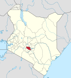
Murang'a County is one of the counties of Kenya's former Central Province. Its largest town and capital is Murang'a, which was referred to as Fort Hall during the colonial era. The county is inhabited mainly by, and is considered the birthplace of the Gikuyu, the largest ethnic group in Kenya.[1] The county had a population of 1,056,640 in the 2019 census.[2] History  When missionaries first came to Kenya, they found the Coast Region already inhabited by Portuguese who had taken the coast strategically for trade from Arab powers in the 16th century. The missionaries ventured into Kenya's rugged interior and Murang'a was one of the first places they settled. When the British set up the East African Protectorate in 1895, their first administrative post (Fort Smith) was located in Murang'a. One of the main highlights of Murang'a's history, however, is the Mau Mau uprising that was led by the Agikuyu community who consider Murang'a their ancestral origin. Murang'a is thus considered, at least by some, the birthplace of the Kenyan independence movement. Missionaries had initially been welcomed by Karuri Wagakure who was the chief of Tuthu. They set up the first mission church in Kenya at Murang'a. Murang'a is also the source of Rivers Maragua, which originates from the heart of the Aberdare Range, Mathioya, Kayahwe, Irati and Muriurio among others. Additionally, Murang'a is known for its fertile soil and good climate, which are good for farming. Among the food crops grown in this county include maize, beans, sweet potatoes, arrow roots, pumpkins, and bananas. Tea and coffee are the county's main cash crops.[3] County governmentThe Constitution of Kenya (2010) created 47 regional governments with the formerly larger Murang'a district as a county. The County Government has two arms, and these are; the County Assembly and the County Executive.[4] .[citation needed] The county uses the code 021 on the national coding scheme and locals famously refer to the county as Metumi. ExecutiveFrom 2013 to 2022, the Executive arm was headed by Hon. Mwangi wa Iria, who was deputized by Hon Gakure Monyo during his first term and Hon Maina Kamau in his second term. In his last term, Mwangi wa Iria was assisted by a team of ministerial members referred to as County Executive Committee (CEC), which had ten other members. The individuals and their portfolios included:
Following the end of the two terms of governorship by Mwangi wa Iria as stipulated by the Kenyan Law, Murang'a County voters voted in Dr. Francis Irungu Kang’ata as their second Governor in August 2022 general elections. Governor Francis Irungu took Oath of Office on 25 August 2022,[5] together with his deputy Stephen Mburu Munania, who became the third Deputy Governor of Murang'a County.[6] County AssemblyMurang’a County Assembly is located in Murang’a town along Kiria-ini Road. The Assembly is housed in the building formerly occupied by the Municipal Council of Murang’a. Murang’a County has 35 MCAs, a speaker and 16 nominated members. The position of the Speaker of the Assembly was formerly held by Hon. Leonard Nduati, deputized by Hon. Moses Gachui. Johnson Mukuha was voted in as the new Speaker in September 2022 by the majority of Members of County Assembly (MCAs).[7] The Assembly is administratively managed by Clerk to the Assembly, a post formerly occupied by Peter Ndegwa Mbue. The current Clerk to the Assembly is Mr. Kuria Thuita.[8] MEMBERS OF MURANG'A COUNTY ASSEMBLY(2022–2027)
Elected Members of County Assembly.
Population
ReligionReligion in Murang'a County [10]
Learning InstitutionsCurrently, there is only one public university in the county, known as Murang’a University of Technology (MUT). MUT was established in September 2011 via Murang’a University College order legal notice No. 129 September 2011 as a constituent College of Jomo Kenyatta University of Agriculture and Technology. MUT is the successor of Murang’a University College and Murang'a College of Technology. The university currently operates under the provision of the Universities Act 2012 CAP 210 B of the laws of Kenya. The university is located 1.5 km from Murang'a town, 85 km North East of Nairobi, 70 km South East of Nyeri and 50 km South West of Embu. There is also Kenya Medical Training College Murang’a Campus (KMTC). This Medical Training College is situated in Murang’a town, approximately 1 km from the town center. Having started in 1950s as a training Centre for Mid-wives, the college morphed into training nurses and gradually started offering Certificate and Diploma Courses in Nursing and Mental Health Psychiatry. Murang'a county also has a teachers training college,Murang'a Teachers college in Makuyu. The college offers training for primary school teachers. Another public institution is the Michuki Technical Training Institute which is located near Karugia Shopping Centre in Kangema subcounty. In 2022 Murang'a Technical Institute a TVET institute was opened in Maragua Town and offers diplomas and certificates in various trades. County subdivisions
The county has seven constituencies:
The county has several towns: Central Kenya RegionUrbanisation
Wealth/Poverty Level
Cash crops in Murang'a county:
Notable people
See alsoReferences
External links |
||||||||||||||||||||||||||||||||||||||||||||||||||||||||||||||||||||||||||||||||||||||||||||||||||||||||||||||||||||||||||||||||||||||||||||||||||||||||||||||||||||||||||||||||||||||||||||||||||||||||||||||||||||||||||||||||||||||||||||||||||||||||||||||||||||||||||||||||||||||||||||||||||||||||||||||||||||||||||||||||||
Portal di Ensiklopedia Dunia


