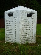
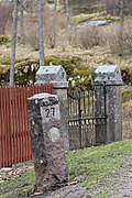
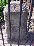
|
Milestone
 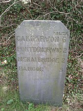 A milestone is a numbered marker placed on a route such as a road, railway line, canal or boundary. They can indicate the distance to towns, cities, and other places or landmarks like mileage signs; or they can give their position on the route relative to some datum location. On roads they are typically located at the side or in a median or central reservation. They are alternatively known as mile markers (sometimes abbreviated MMs), mileposts or mile posts (sometimes abbreviated MPs). A "kilometric point" is a term used in metricated areas, where distances are commonly measured in kilometres instead of miles. "Distance marker" is a generic unit-agnostic term. Milestones are installed to provide linear referencing points along the road. This can be used to reassure travellers that the proper path is being followed, and to indicate either distance travelled or the remaining distance to a destination. Such references are also used by maintenance engineers and emergency services to direct them to specific points where their presence is required. This term is sometimes used to denote a location on a road even if no physical sign is present. This is useful for accident reporting and other record keeping (e.g., "an accident occurred at the 13-mile mark" even if the road is only marked with a stone once every 10 miles). HistoryRoman Empire 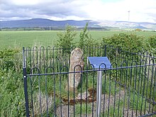 Miliarium (Classical Latin: [miːllɪˈaːrɪ.ũː ˈau̯rɛ.ũː]) were originally stone obelisks – made from granite, marble, or whatever local stone was available – and later concrete posts. They were widely used by Roman Empire road builders and were an important part of any Roman road network: the distance travelled per day was only a few miles in some cases.[citation needed] Many Roman milestones only record the name of the reigning emperor without giving any placenames or distances.[1] The first Roman milestones appeared on the Appian Way. At the centre of Rome, the "Golden Milestone" was erected to mark the presumed centre of the empire: this milestone has since been lost. The Golden Milestone inspired the Zero Milestone in Washington, D.C., intended as the point from which all road distances in the United States should be reckoned. Odometers were used to measure the Roman milestone spacing, most likely based on Ancient Greek technology.[citation needed] Byzantine EmpireA mile-marker monument, the Milion, was erected in the early 4th century AD in Constantinople. It served as the starting point for measurement of distances for all the roads leading to the cities of the Byzantine Empire, and had the same function as the Milliarium Aureum of Ancient Rome. The Milion survived intact until at least the late 15th century. Its fragments were discovered again in the late 1960s. A fragment is re-erected as a pillar. Islamic civilizationIn Islamic civilisation, use of milestone began in the first Islamic century. The Umayyad caliph Abd al-Malik bin Marwan laid the milestones along the paths that travelers used, and some were found in the city of Faiq in the Syrian Golan, which is, Faiq, one of the main road stations throughout the Islamic ages. The function of these stones was to guide travelers and introduce them to long distances, as the separation between one and the other was one mile. Many of these stones were found in more than one location, one in the Islamic Archeology Museum in Istanbul and another in the Jerusalem Museum. A translation of the text written on the stone currently found in the Kasserine Museum in the Golan reads as follows:
Post-Medieval Europe In Europe, the distance measured typically starts at specified point within a city or town, as many roads were named for the towns at either end. For example, in London, United Kingdom, a plaque near the Eleanor cross at Charing Cross is the reference point from which distances from London to other towns and cities are measured. In the UK, milestones are especially associated with former turnpike roads. The British built many milestones on the island of Malta. They consisted of large slabs of local hard rock and they were engraved with the distance to or from a particular location. Many of these were defaced in World War II to disorientate forces in a potential invasion. Despite this, a very small number of milestones still exist undefaced, and one of these is now in the Malta at War Museum.[2] India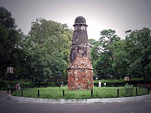 The Kos Minars or Mile Pillars are medieval milestones that were made by the 16th-century Afghan Ruler Sher Shah Suri and later on by Mughal emperors. These Minars were erected by the Mughal Emperors on the main highways across the empire to mark the distance. The Kos Minar is a solid round pillar, around 30 feet (9.1 m) in height that stands on a masonry platform built with bricks and plastered over with lime. Though not architecturally very impressive, being milestones, they were an important part of communication and travel in a large empire.[3] Kos is an ancient Indian unit of distance. It can represent either a distance of approximately 1.8 kilometres (1.1 mi) or 3.2 kilometres (2.0 mi). Minar is a Persian word for tower. Abul Fazl recorded in Akbar Nama that in the year 1575 AD, Akbar issued an order that at every Kos on the way from Agra to Ajmer, a pillar or a minar should be erected for the comfort of the travelers.[4][5] Modern highwaysThe historical term milestone is still used today, even though the "stones" are typically metal highway location markers and in most countries use kilometres and metres rather than miles and yards. Also found today are more closely spaced signs containing fractional numbers, and signs along railways, beaches and canals. AustraliaMetrication in Australia caused the former mile markers to be gradually replaced with 10 km markers on highways and country roads, which are referred to as "kilometre plates". Kilometre plates have white text on a trapezoidal green background, and are generally located about a metre above the ground. They have a letter which indicates the town or city they are referring to, and a number, which is the distance in kilometres to that town or city. Kilometre plates are now generally 5 km apart on major highways and 10 or 20 km apart on less popular or rural highways, though there are many exceptions. Kilometre plates are supplemented by signboards, which display distances to several towns ahead. Some mile markers are retained as curiosities (see gallery). These include stone markers on Victoria's Glenelg Highway at Delacombe, CanadaUsage varies by province, as highways are under provincial jurisdiction. In Alberta, for example, kilometre markers are green metal signs with white lettering, and are generally placed every 4 km starting at the last major intersection to the south or west, depending on whether the route runs north–south or east–west. India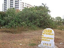 Milestones on National highways of India typically have white backgrounds with yellow tops (on national highways) or green tops (on state highways). The names of cities and distances are painted in black. The names of the nearest towns and cities are written along with distance in kilometres. On undivided highways, both sides of the milestones are used, telling the distance to the nearest cities in each direction. The highway number is written on the head of the milestone. The sum of the distances of two nearest cities in each direction from the milestone is listed on the side. Philippines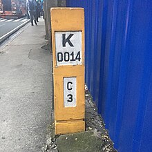 Milestones in the Philippines are found in highways, one kilometer apart, and are found in pairs, one on each side of the road. These are short yellow concrete posts, with two labels on a white background, written in black. On top is a large "K" (or "KM"), and a number, referencing the distance from the kilometre zero. While the national kilometre zero is in Rizal Park, each major island has its own kilometre zero. The milestones on the Luzon mainland reference Rizal Park's kilometre zero. The second label is a letter, standing for the first letter of the next town if one is traveling on that direction, then the distance in kilometers, from the town. In the example to the right, a milestone in Ortigas Avenue in Pasig says it is 14 kilometers (8.7 mi) from Rizal Park, and 3 kilometers (1.9 mi) from Cainta. On the other side, the milestone there says it is 2 kilometers (1.2 mi) from San Juan. Most milestones only have labels on one side, facing the driver. Others have labels on all four sides. United KingdomIn the UK, driver location signs are placed every 500 metres (550 yd) along each side of motorways, and along some other major roads. They were first introduced in 2003, and they complement distance marker posts, small roadside posts at 100 metres (110 yd) intervals, used for road maintenance and administrative purposes. Both types of sign display a unique location number. The number is given without units but is the distance in kilometres from a designated datum location for the road.[6] United States In the U.S. Interstate Highway System, the numbers usually measure the distance to the southern or western state line, or the route's terminus, if the national southern or western terminus lies in that state. The numbering system for other highways varies by state; most use a system mirroring that of the Interstate System, other states, such as Illinois, California, and Kentucky, use the county line as the zero mile marker, while others, including Missouri, do not sign mile-markers at all (except on Interstates). Arizona has a rather unusual system, where a route's mileposts continue those from its original host. Often, the exits are numbered according to the nearest milepost, known as the mile-log system. From the beginning of the Interstate system until the mid-2000s, most Interstate highways had markers every mile. Since that time, many states have installed more markers every 0.25 mile, every 0.2 mile, or in some metro areas, every 0.1 mile. Some historic and scenic routes – such as along the Blue Ridge Parkway in North Carolina and Virginia and the Overseas Highway of the Florida Keys – use mileposts to mark points of interest or (in the cases of many businesses along the Overseas Highway) as a portion of their address. Myanmar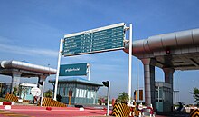  In Myanmar, furlongs have been used at least until 2010 in conjunction with miles to indicate distances on highway signs, for example on the Yangon-Mandalay Expressway. ZimbabweZimbabwean milestones are constructed of cast concrete painted white with the kilometre distance indented and painted black.[7] There is no distinction between state and national road-sign markings. They were originally sited every 500 metres by the Rhodesian Ministry of Roads and Road Traffic, starting at zero from the largest town or city. In 1980, the Zimbabwean government began placing new markers 1 km apart and damaged or missing half kilometre markers were no longer replaced. Railway mileposts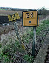 The Railways Clauses Consolidation Act 1845[8] compels UK railway companies to provide their passengers with a means of determining the distance travelled (fares were set by distance at this time). Section 94 states:
Similar laws were passed in other countries. On the modern railway, these historical markers are still used as infrastructure reference points. At many points, the distances shown on the markers are based upon points no longer on the network – for example, distances measured via a closed line or from a junction which has subsequently been moved. Whole mileposts are usually supplemented by half and quarter posts. Structure signs often include the mileage to a fair degree of precision; in the UK, the chain (equal to 1⁄80 mile or 20 metres) is the usual accuracy. In the U.S. and Canada, miles are "decimalized", so that, for example, there may be a "milepost 4.83" to mark a junction, crossing, bridge or tunnel. In metricated areas, the equivalent is the kilometric point. BoundariesSurveyors place milestones to mark the boundaries between the jurisdictions separated by borders. A series of such boundary markers exists at one mile (1.6 km) intervals along the borders of the District of Columbia in the United States. Gallery
See also
References
External linksWikimedia Commons has media related to Milestones.
|
Portal di Ensiklopedia Dunia


