Lucky Lake

Lucky Lake
Village of Lucky Lake
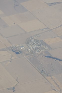
Aerial view of Lucky Lake
Lucky Lake is located in Saskatchewan
Lucky Lake
Lucky Lake
Location of Lucky Lake in Saskatchewan
Lucky Lake is located in Canada
Lucky Lake
Lucky Lake
Lucky Lake (Canada)
Coordinates: 50°59′53″N 107°09′00″W / 50.998°N 107.150°W / 50.998; -107.150
Country Canada
Province Saskatchewan
RegionSouthwest
Census division7
Rural MunicipalityCanaan No. 225
Post office FoundedMarch 28, 1908
Incorporated (Village)November 23, 1920
Government
 • TypeMunicipal
 • Governing bodyLucky Lake Village Council
 • AdministratorMelanie Dyck
Area
 • Land0.66 km2 (0.25 sq mi)
Population
 (2016)
 • Total
289
 • Density438.7/km2 (1,136/sq mi)
Time zoneUTC-6 (CST)
Postal code
S0L 1Z0
Area code306
Highways Highway 42
Highway 45

Highway 646
RailwayCanadian National Railway
[2][3][4][5]

Lucky Lake (2016 population: 289) is a village in the Canadian province of Saskatchewan within the Rural Municipality of Canaan No. 225 and Census Division No. 7. The Village is located at the junction of Highway 42, Highway 45 and Highway 646 approximately 90 km northeast of Swift Current, Saskatchewan.

History

Lucky Lake incorporated as a village on November 23, 1920.[6]

Demographics

Population history
(1981–2016)
YearPop.±%
1981333—    
1986382+14.7%
1991341−10.7%
1996353+3.5%
2001354+0.3%
2006295−16.7%
2011287−2.7%
2016289+0.7%
Source: Statistics Canada via Saskatchewan Bureau of Statistics[7][8]

In the 2021 Census of Population conducted by Statistics Canada, Lucky Lake had a population of 270 living in 127 of its 145 total private dwellings, a change of -6.6% from its 2016 population of 289. With a land area of 0.82 km2 (0.32 sq mi), it had a population density of 329.3/km2 (852.8/sq mi) in 2021.[9]

In the 2016 Census of Population, the Village of Lucky Lake recorded a population of 289 living in 134 of its 154 total private dwellings, a 0.7% change from its 2011 population of 287. With a land area of 0.66 km2 (0.25 sq mi), it had a population density of 437.9/km2 (1,134.1/sq mi) in 2016.[10]

Economy

Agriculture and agriculture services constitute the largest component of the town's economy. Typical crops grown in the area include durum wheat, spring wheat, peas, lentils, and canola. Flax, beans and mustard are also grown to a lesser extent. Nearby Lake Diefenbaker provides water for irrigation so that additional crops such as potatoes can be grown. Wild West Steelhead, is an aquaculture farm that raises Steelhead Trout in the lake. The company employs many people in its operations that comprise the steps of egg incubation to the production of finished fillets.[11]

In the past, the provincial government's efforts (via a partnership known as SPUDCO) to create a potato growing industry in the province led to local jobs being created to grow and package potatoes. SPUDCO eventually failed and the local potato growing industry has been slow to recover.

Attractions

See also

References

  1. ^ "Census Profile". 2016 Census. Statistics Canada.
  2. ^ "2011 Community Profiles". Statistics Canada. Government of Canada. Retrieved 2014-04-09.
  3. ^ National Archives, Archivia Net. "Post Offices and Postmasters". Archived from the original on 2006-10-06. Retrieved 2014-07-15.
  4. ^ Government of Saskatchewan, MRD Home. "Municipal Directory System". Archived from the original on 2016-01-15. Retrieved 2014-07-15.
  5. ^ Commissioner of Canada Elections, Chief Electoral Officer of Canada (2005). "Elections Canada On-line". Archived from the original on 2007-04-21. Retrieved 2014-07-15.
  6. ^ "Urban Municipality Incorporations". Saskatchewan Ministry of Government Relations. Archived from the original on October 15, 2014. Retrieved June 1, 2020.
  7. ^ "Saskatchewan Census Population" (PDF). Saskatchewan Bureau of Statistics. Archived from the original (PDF) on September 24, 2015. Retrieved May 31, 2020.
  8. ^ "Saskatchewan Census Population". Saskatchewan Bureau of Statistics. Retrieved May 31, 2020.
  9. ^ "Population and dwelling counts: Canada, provinces and territories, census divisions and census subdivisions (municipalities), Saskatchewan". Statistics Canada. February 9, 2022. Retrieved April 1, 2022.
  10. ^ "Population and dwelling counts, for Canada, provinces and territories, and census subdivisions (municipalities), 2016 and 2011 censuses – 100% data (Saskatchewan)". Statistics Canada. February 8, 2017. Retrieved May 30, 2020.
  11. ^ Wild West Steelhead homepage url=http://www.wildweststeelhead.com/

50°59′53″N 107°09′00″W / 50.998°N 107.150°W / 50.998; -107.150