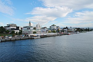
Los Ríos Region

Los Ríos Region
Región de Los Ríos
Alerce Costero National Park
Coat of Arms of Los Ríos Region
Map of Los Ríos Region
Coordinates: 39°48′30″S 73°14′30″W / 39.80833°S 73.24167°W / -39.80833; -73.24167
Country Chile
CapitalValdivia
ProvincesValdivia, Ranco
Government
 • IntendantCésar Asenjo (UDI)
Area
 • Total18,429.5 km2 (7,115.7 sq mi)
 • Rank11
Highest elevation
2,236 m (7,336 ft)
Lowest elevation
0 m (0 ft)
Population
 (2017 census)[1]
 • Total380,181
 • Rank11
 • Density21/km2 (53/sq mi)
GDP (PPP)
 • Total$4.703 billion (2014)
 • Per capita$11,711 (2014)
ISO 3166 codeCL-LR
HDI (2019)0.795[3]
high
WebsiteOfficial website

The Los Ríos Region (Spanish: Región de Los Ríos, pronounced [los ˈri.os], lit. Region of the Rivers) is one of Chile's 16 regions, the country's first-order administrative divisions. Its capital is Valdivia. It began to operate as a region on October 2, 2007, having been created by subdividing the Los Lagos Region in southern Chile. It consists of two provinces: Valdivia and the newly created Ranco Province, which was formerly part of Valdivia Province.

Economy

The region's economy is based on forestry, cattle farming, tourism, manufacturing, and services. Key industries include the Valdivia Pulp Mill, Valdivia's shipyards, and the dairy facilities located in La Unión.

The population of the region was 380,181 according to the 2017 census. Approximately half of the population lives in the commune of Valdivia.

Government and administration

The capital of Los Rios Region is Valdivia.

The region's 12 communes are distributed between 2 provinces. These are:

Valdivia is part of Northern Patagonia as its wild virgin forest embrace the Patagonian Cordillera following the river Calle Calle down to the Pacific Ocean. It is known in Patagonia the term " Bosque Valdiviano" referring to the primitive virgin forest found in the cordillera valleys of Valdivia which include dense masses of native trees. These Forest are present in some parts of Northern Patagonia both in Chile and Argentina.

Commune government

Demography

In the last census, of 2017, Los Ríos Region (then Valdivia Province) registered a population of 380,181 inhabitants. By this number the region is ranked 10th among Chile's 16 regions and has a share of 2.35% of the national total. The regions rural population represents 32% of the total, which is explained by the fact that almost half of the population lives in the city of Valdivia and that the cities of Río Bueno and La Unión have together 50,000 inhabitants. This percentage of rural population is well above the national average which is of 13.4%. The population of Los Ríos has a relatively high percentage of people who self-identify as indigenous of 11.3% it means 40,515 persons. To compare, the national average is of 4.58%. It has a large German presence alike the nearby Los Lagos Region. See also German colonization of Valdivia, Osorno and Llanquihue

Valdivian Fort System founded by the Spaniards in Corral.
Valdivia.
Demography by commune in Los Ríos Region
Commune Population Density
(hab/km2)
Poverty (%) Rural
population (%)
Indigenous
peoples (%)[i 1]
Illiteracy (%)
Corral 5,463 7.1 37.3 32.8 11.5 9.9
Futrono 14,981 7.1 35.1 43.9 17.9 8.0
La Unión 39,447 18.5 26.5 35.1 9.2 6.7
Lago Ranco 10,098 5.7 29.6 78.2 31.8 9.3
Lanco 15,107 28.4 35.0 31.3 19.3 7.6
Los Lagos 20,168 11.3 35.5 53.0 3.9 9.1
Máfil 7,213 12.4 21.3 47.4 6.3 8.9
Paillaco 19,237 21.5 29.7 48.8 4.9 7.2
Panguipulli 33,273 10.1 34.4 52.2 30.8 14.1
Río Bueno 32,627 14.8 36.8 53.9 11.9 9.7
Mariquina 18,223 13.8 29.4 51.0 23.2 8.5
Valdivia 140,559 138.4 20.8 7.5 5.0 2.3

Settlements

List of settlements in Los Ríos Region [1]
Name Population Type Commune
Antilhue 934 Village Los Lagos
Calafquén 103 Hamlet Panguipulli
Caleta Chaihuín 36 Hamlet Corral
Choshuenco 625 Village Panguipulli
Coñaripe 1,416 Town Panguipulli
Corral 3,670 Town Corral
Curiñanco 274 Hamlet Valdivia
Futrono 6,603 City Futrono
La Unión 25,615 City La Unión
Lanco 7,817 City Lanco
Lago Ranco 2,205 Town Lago Ranco
Liquiñe 1,205 Town Panguipulli
Llifén 748 Town Futrono
Los Lagos 9,479 City Los Lagos
Máfil 3,793 Town Máfil
Malalhue 2,566 Town Lanco
Neltume 2,125 Town Panguipulli
Mehuín 1,135 Town Mariquina
Niebla 2,202 Town Valdivia
Nontuela 1,048 Town Futrono
Riñihue 243 Hamlet Los Lagos
Río Bueno 15,054 City Río Bueno
Panguipulli 11,142 City Panguipulli
Paillaco 9,973 City Paillaco
Puerto Fuy 391 Village Panguipulli
Puerto Pirihueico 13 Village Panguipulli
San José de la Mariquina 7,790 City Mariquina
Pishuinco 228 Hamlet Valdivia
Punucapa 75 Hamlet Valdivia
Torobayo 148 Hamlet Valdivia
Valdivia 127,750 City Valdivia

History

Map of the Los Rios Region and the remaining Los Lagos Region (Grey). Paillaco is in Valdivia province instead of Ranco Province, as initially proposed.

Republic of Chile

In the beginning of the Chilean Republic, Valdivia was one of the original eight provinces established. The reason for the incorporation was not so much the value of Valdivia, per se, but to minimize the threat to Chilean independence posed by Spaniards in the territory. As German Chilean immigrants arrived in the city during the mid 19th century, the local economy started to develop industries. By 1900, Valdivia was the third most industrialized city in Chile, however, a period of decline started with the world wars. After the Great Chilean earthquake in 1960, Valdivia fell deeper into decline. Much of the city was destroyed and many people left the city.

In 1974 the military junta reorganized the political divisions of Chile deciding that Valdivia was no longer adequate to be a "first class administrative territory" capital. Hence, it was reclassified into a province within Los Lagos Region and Puerto Montt was designated capital. Valdivians greatly resented this decision because they felt they were better suited to be the capital than Puerto Montt, holding forth the following arguments:

  • Valdivia was founded in 1552,
  • Valdivia had resisted pirate attacks and hostile natives,
  • Valdivia had survived several earthquakes,
  • Puerto Montt, founded in 1853, three hundred and one years later, was a considerably newer city.

Creation of the new region

On October 19, 2005 Chilean President Ricardo Lagos signed a bill allowing for the creation of Los Ríos Region ("The Rivers Region"). The bill was approved by Congress on December 19, 2006; it was signed into law on March 16, 2007 and published on April 5, 2007. According to the Roman numeral designation, currently used in Chile, this region is number XIV (fourteenth). However, steps are being taken to no longer refer to the regions by numbers.

Osorno

When the new region was considered by Congress, Osorno made several proposals:

  • To make Osorno the new capital
  • To make La Unión the capital
  • To expand Osorno Province adding to it the comuna of Río Bueno.

It was proposed that Osorno Province join as the third province of the new region, instead of remaining the fourth province of Los Lagos Region, however, in a referendum held in 2006 the residents of that province rejected the idea.

Geography

Map of the drainage network of Valdivia River. Valdivia River empties to Corral Bay in the Pacific Ocean. View of Panguipulli Lake.

Los Ríos Region lies in the southern temperate zone and in a tectonically active milieu. Four distinct landscape types, or morphological units, can be distinguished in the region. These are from west to east; the Coastal Range, the Intermediate Depression, the Precordillera and the Andes. These units are oriented parallel to the coast and the subduction zone there. An exception to this are the eastern hills in Mariquina and Máfil that despite belonging to the Coast Range system adrift eastwards and comes very close to the Precordillera cutting the Intermediate Depression in two. The Coastal Cordillera does not exceed the 1000 m in height being Cerro Oncol (715 m) the highest point in the section north of Valdivia River. The Coast Range is cut by Valdivia and Bueno Rivers, deeply incised rivers that drains the inland. Most of the Coast is covered by native Valdivian temperate rain forest, although it has in some parts been substituted by plantations of exotic species, specially Douglas firs and eucalyptus.

Two great agricultural flatlands exist in the region, the Mariquina valley and Los Llanos of La Unión and Río Bueno. The first one is a tectonic depression in the Coast Range connected to Valdivia by Cruces River and the second is the continuation of the Intermediate Depression that re-opens south of Máfil. The flatlands and mayor river valleys form large, open, cultural landscapes used as grassing meadows or for growing crops.

The Precordillera is a narrow band characterized by hosting a large number of deep glacial piedmont lakes that are dammed by moraines. These lakes intersect forested granitic mountain massifs of up to 1500 m. The Precordilleran hills and mountains have step slopes to the north and south as the main direction of the Quaternary glaciers where from east to west. Many lake shores are cleared lands where agriculture, settlements and resort areas develop.

Andes

The proper Andes extends from the eastern half of the Precordillean lakes to the border with Neuquén Province in Argentina. The Andes in this part of Chile, the Zona Sur, has almost escaped the Andean orogenesis. Here the Andes consist of old granitic plutons such as the Panguipulli Batholith and the North Patagonian Batholith together with volcanics and some minor areas of sediments and metasediments. As result of the minimal Andean mountainbuilding the mountains shows little rejuvenation and are mostly shaped by erosive agents, specially glaciers. An exception to this are the several volcanoes that rises east of the piedmont lakes, this volcanoes are among the most active in Chile and as result their form are influenced by the eruptions; either in constructive manner such as Villarrica Volcano or more destructive like Quetrupillán. The fact that these volcanoes have the ability to build up cones and rise again after erosion and explosive eruptions makes many of them the highest mountains in the region and Zona Sur. The volcanoes of Los Ríos Regions belong to the Southern Volcanic Zone of Andes, whose current activity front is located about 200 km west from the main Andean cordillera, this makes volcanoes stand out as isolated snow-covered cones of more than 2000 m, above the lower mountains that rarely pass the 1500 m. The main cordillera makes up the continental divide and are therefore according to the 1881 Argentina-Chile treaty the border between the two nations. Faults and glacier action have however made a gap at the site of Huahum Pass where waters from the eastern Argentine slopes drains westward to the Pacific Mountains at the cordillera may reach at most some 2000 m in height. Andean valleys of Los Ríos Region are deep and broad and either used for raising cattle or for wood lodging, as well as tourism and protection of biodiversity. These glacial valleys are placed above old Miocene rivers and faults. The chief fault is the Liquiñe-Ofqui Fault that crosses the whole region from north to south allowing numerous valleys to develop above it. The Liquiñe-Ofqui Fault is tectonically active causing minor tremors and is also believed responsible by geologists for the alignment of the volcanoes of the southern section of the Southern Volcanic Zone. Along Liquiñe-Ofqui Fault there are several hotsprings such as Liquiñe, Chihuío, Termas Geométricas, Termas Vergara and Termas de Coñaripe.

Hydrography

The region owes its name to the river network that converge in Valdivia River at the city of Valdivia. These rivers drain most of northern Los Ríos Region as well as parts of Araucanía Region and Neuquén Province in Argentina. A second large river, Bueno River is responsible for the draining of the southern parts of the region including Ranco Lake, Chile's 4th largest lake. Bueno River and its tributary Pilmaiquén River also drain large areas of Osorno Province and form the southern boundary of the region. These two big river systems receive a continuous inflow of water due to being fed by lakes and lake chains in the Andes. Valdivia River is provided by the Seven Lakes chain plus Lácar Lake and Bueno River from Ranco, Maihue and Puyehue Lake. The large lakes in the interior are fed by rainwater and snow melt from the higher mountains. Glaciers and semipermanent snow patches have relatively low share flow volume of the main rivers.

Culture

The Valdivia International Film Festival (FICV) is the most important film event in Chile, one of the most important worldwide and in Latin America. It has been held since 1994, generally during the month of October.[4]

The Valdivia Book Fair is organized annually by the Municipal Cultural Corporation of the city, with the support of the Government of Los Ríos, in the Saval Park. In this context, several authors born in the Los Ríos Region stand out, such as Maha Vial,[5] Iván Espinoza Riesco,[6] José Baroja,[7] Aldo Astete Cuadra,[8] Efraín Miranda Cárdenas, to name a few.

The International Sculpture Symposium of Valdivia is cataloged as one of the most important events in Chile and one of the most prestigious in Latin America.[9]

The Valdivia International Jazz Festival was born in July 2000. Today it is considered the oldest festival in Chile and one of the most important in this musical genre in the Southern Cone.[10]

See also

Footnotes

  1. ^ In the 2002 Census indigenous peoples were calculated on the basis of selfidentification. The dominant indigenous peoples in Los Ríos Region are Huilliche and Mapuche, while indigenous peoples from other areas of Chile makes up a tiny minority, located mainly in Valdivia.

References

  1. ^ a b "Los Ríos Region". Government of Chile Foreign Investment Committee. Retrieved 13 March 2010.[permanent dead link]
  2. ^ Regions and Cities > Regional Statistics > Regional Economy > Regional GDP per Capita, OECD.Stats.
  3. ^ "Sub-national HDI - Area Database - Global Data Lab". hdi.globaldatalab.org. Retrieved 26 October 2021.
  4. ^ "29º Festival Internacional de Cine de Valdivia". 29º FICValdivia (in European Spanish). Retrieved 2022-08-08.
  5. ^ Marimón, Guido Macari (2020-10-27). "Muere la poeta y actriz Maha Vial". La Tercera. Retrieved 2022-08-08.
  6. ^ "Iván Espinoza Riesco". comunidadcreativalosrios.cultura.gob.cl. Retrieved 2022-08-08.
  7. ^ Fernández, Antonio Cazás. ""La escritura le aportó sentido, coherencia e identidad a mi vida"". www.elcorreogallego.es (in European Spanish). Retrieved 2022-08-08.
  8. ^ "Aldo Astete Cuadra – El Ser que acecha entre la Lluvia". comunidadcreativalosrios.cultura.gob.cl. Retrieved 2022-08-08.
  9. ^ Cares, Leslie. "Convocatorias Simposio Internacional de Escultura Valdivia 2022". www.ccm-valdivia.cl. Retrieved 2022-08-08.
  10. ^ "Festival Internacional de Jazz de Valdivia". comunidadcreativalosrios.cultura.gob.cl. Retrieved 2022-08-08.

Read other articles:

20th commissioner of the RCMP Giuliano ZaccardelliCOM CStJ OMRIZaccardelli in 200620th Commissioner of the Royal Canadian Mounted PoliceIn office1 September 2000 – 15 December 2006Preceded byPhilip MurraySucceeded byBeverley Busson (interim) Personal detailsBorn1946 or 1947 (age 77–78)[1]Prezza, Abruzzo, ItalyAwards Legion of Honour – Officer (2003) Giuliano Zaccardelli COM CStJ OMRI (born c. 1947)[1] is an Italian-born Canadian retired p…

Culture that originated from North America FolsomMap of Folsom tradition (modern shoreline shown)Geographical rangeGreat PlainsPeriodLithic or Paleo-Indian stageDatesc. 10800 – 10200 BCE[1]Type siteFolsom sitePreceded byClovis culture A Folsom spearpoint approximately life size. The Folsom tradition is a Paleo-Indian archaeological culture that occupied much of central North America from c. 10800 BCE to c. 10200 BCE. The term was first used in 1927 by Jesse Dade Figgins…

Le informazioni riportate non sono consigli medici e potrebbero non essere accurate. I contenuti hanno solo fine illustrativo e non sostituiscono il parere medico: leggi le avvertenze. Avambraccio umano, tra gomito e polso L'avambraccio è la parte dell'arto superiore compresa tra il gomito e il polso. Il termine è usato in anatomia per distinguerlo dal braccio, parte compresa tra la spalla e il gomito. Indice 1 Anatomia 1.1 Ossa 1.2 Articolazioni 1.3 Muscoli 1.4 Nervi 1.5 Vasi sanguigni 1.6 Al…
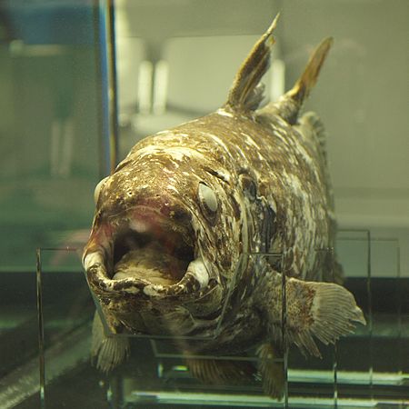
CoelacanthRentang fosil: Devon awal– sekarang,[1] 409–0 jtyl PreЄ Є O S D C P T J K Pg N Latimeria chalumnae Latimeria menadoensis Klasifikasi ilmiah Domain: Eukaryota Kerajaan: Animalia Filum: Chordata Kelas: ActinistiaCope, 1871 Ordo: CoelacanthiformesHuxley, 1861 Spesies tipe Coelacanthus granulatus (punah)Agassiz, 1839 famili Lihat teks Coelacanth (IPA: [ˈsiːləˌkænθ] SI-lo-kèn) adalah nama ordo (bangsa) ikan yang di masa ini hanya terdiri dari dua spesies di dalam g…

Suburb of Hobart, Tasmania, AustraliaSouth ArmHobart, TasmaniaSouth Arm from kunanyi / Mount WellingtonSouth ArmCoordinates43°1′42″S 147°25′1″E / 43.02833°S 147.41694°E / -43.02833; 147.41694Population963 (SAL 2021)[1]Postcode(s)7022Location32 km (20 mi) SE of Rosny ParkLGA(s)ClarenceRegionHobartState electorate(s)FranklinFederal division(s)Franklin Suburbs around South Arm: Derwent River Opossum Bay Ralphs Bay Derwent River South Arm Cl…
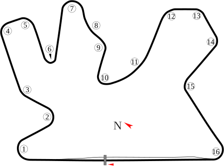
  Grand Prix Qatar 2020Detail lombaLomba ke 1 dari 15Grand Prix Sepeda Motor musim 2020Tanggal8 Maret 2020Nama resmiQNB Grand Prix of QatarLokasiLosail International Circuit, Doha, QatarSirkuitFasilitas balapan permanen5.380 km (3.340 mi)Moto2Pole positionPembalap Joe Roberts KalexCatatan waktu 1:58.136 Putaran tercepatPembalap Tetsuta Nagashima KalexCatatan waktu 1:59.218 di lap 8 PodiumPertama Tetsuta Nagashima KalexKedua Lorenzo Baldassarri KalexKetiga Enea Bastianini Kale…

Arcolacity(EN) City of Arcola Arcola – Veduta LocalizzazioneStato Stati Uniti Stato federato Texas ConteaFort Bend TerritorioCoordinate29°30′04″N 95°27′49″W / 29.50111°N 95.46361°W29.50111; -95.46361 (Arcola)Coordinate: 29°30′04″N 95°27′49″W / 29.50111°N 95.46361°W29.50111; -95.46361 (Arcola) Altitudine20 m s.l.m. Superficie5,12 km² Abitanti1 642 (2010) Densità320,7 ab./km² Altre informazioniPrefisso71…

2017 film by Holger Tappe Monster FamilyTheatrical release posterDirected byHolger TappeScreenplay byDavid SafierCatharina JunkBased onHappy Familyby David SafierProduced byHolger TappeStarring Emily Watson Nick Frost Jessica Brown Findlay Celia Imrie Catherine Tate Jason Isaacs Edited byBjörn TeubnerMusic byHendrik SchwarzerProductioncompaniesAmbient Entertainment GmbHUnited EntertainmentMack MediaAgirTimeless FilmsRothkirch Cartoon FilmSky Cinema Original FilmsVideoBackDistributed byWarner Br…

Province in Sahel Region, Burkina FasoOudalanProvinceLocation in Burkina FasoProvincial map of its departmentsCountry Burkina FasoRegionSahel RegionCapitalGorom-GoromArea • Province9,832 km2 (3,796 sq mi)Population (2019 census)[1] • Province158,146 • Density16/km2 (42/sq mi) • Urban9,752Time zoneUTC+0 (GMT 0) Oudalan is one of the 45 provinces of Burkina Faso, located in its Sahel Region. Its capital is Gorom-…

هنودمعلومات عامةنسبة التسمية الهند التعداد الكليالتعداد قرابة 1.21 مليار[1][2]تعداد الهند عام 2011ق. 1.32 مليار[3]تقديرات عام 2017ق. 30.8 مليون[4]مناطق الوجود المميزةبلد الأصل الهند البلد الهند  الهند نيبال 4,000,000[5] الولايات المتحدة 3,982,398[6] الإمارا…

豪栄道 豪太郎 場所入りする豪栄道基礎情報四股名 澤井 豪太郎→豪栄道 豪太郎本名 澤井 豪太郎愛称 ゴウタロウ、豪ちゃん、GAD[1][2]生年月日 (1986-04-06) 1986年4月6日(38歳)出身 大阪府寝屋川市身長 183cm体重 160kgBMI 47.26所属部屋 境川部屋得意技 右四つ・出し投げ・切り返し・外掛け・首投げ・右下手投げ成績現在の番付 引退最高位 東大関生涯戦歴 696勝493敗66…

Italian composer and organist (1725–1813) Ferdinando Gasparo BertoniBorn15 August 1725 (1725-08-15)SalòDied1 December 1813(1813-12-01) (aged 88)Desenzano del GardaNationalityItalianOccupation(s)Composer and organist.Notable work Composed 70 operas Composed 200 sacred works Ferdinando Gasparo Bertoni (15 August 1725 – 1 December 1813) was an Italian composer and organist. Early years He was born in Salò, and began his music studies in Brescia, not far from his birthplace. Around 1…
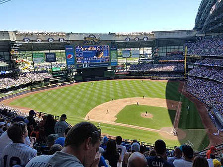
2018 National League Championship Series Team (Wins) Manager(s) Season Los Angeles Dodgers (4) Dave Roberts 92–71 (.564), GA: 1 Milwaukee Brewers (3) Craig Counsell 96–67 (.589), GA: 1DatesOctober 12–20MVPCody Bellinger (Los Angeles)UmpiresScott Barry (Games 1–2)Gerry Davis (crew chief)Greg Gibson (Games 3–7)Brian Gorman, Alan Porter, Hunter Wendelstedt, Jim WolfBroadcastTelevisionFS1 (Games 1, 3–7)Fox (Game 2)TV announcersJoe Buck, John Smoltz, Ken Rosenthal and Tom VerducciRadioESP…

Divizia A 1997-1998 Competizione Liga I Sport Calcio Edizione 80ª Organizzatore FRF Date dal 2 agosto 1997al 2 maggio 1998 Luogo  Romania Partecipanti 18 Risultati Vincitore Steaua București(20º titolo) Retrocessioni Chindia TârgovișteSportul StudențescJiul Petroșani Statistiche Miglior marcatore Vasile Oană (22) Cronologia della competizione 1996-1997 1998-1999 Manuale La Divizia A 1997-1998 è stata la 80ª edizione della massima serie del campionato di calcio rumeno,…

يفتقر محتوى هذه المقالة إلى الاستشهاد بمصادر. فضلاً، ساهم في تطوير هذه المقالة من خلال إضافة مصادر موثوق بها. أي معلومات غير موثقة يمكن التشكيك بها وإزالتها. (فبراير 2016) الدوري المصري الممتاز الموسم 1982–83 البلد مصر  المنظم الاتحاد المصري لكرة القدم  عدد الفرق 12   الفائ…

Syesha Mercado Syesha Mercado (lahir 2 Januari 1987) adalah seorang aktris, penyanyi, model, dan penulis lagu Amerika.[1] Ia merupakan seorang anak keturunan Afrika, Amerika, dan Puerto Rico.[1] Darah seninya menurun dari keluarganya.[1] Ibunya adalah seorang penyanyi latar (backing vocal) penyanyi Motown.[1] Namanya mulai dikenal luas setelah ia berhasil menjadi salah satu finalis dalam American idol musim ketujuh.[2] Ia juga merupakan salah satu kontesta…

Civil ensign of the United Kingdom For the 1934 film, see Red Ensign (film). Red EnsignRed DusterUseCivil ensign Proportion1:2AdoptedBritish Merchant NavyDesignRed with the Union Jack occupying one quarter of the field and placed in the canton. World War II morale poster A well used Red Ensign worn on a motorboat The Red Ensign or Red Duster is the civil ensign of the United Kingdom of Great Britain and Northern Ireland. It is one of the British ensigns, and it is used either plain or defaced wi…

Federal district court whose jurisdiction is the state of Minnesota United States District Court for the District of Minnesota(D. Minn.)LocationMinneapolisMore locationsSaint PaulGerald W. Heaney Federal Building, United States Courthouse and Custom House(Duluth)Edward J. Devitt U.S. Courthouse and Federal Building(Fergus Falls)WinonaMankatoBemidjiAppeals toEighth CircuitEstablishedMay 11, 1858Judges7Chief JudgePatrick J. SchiltzOfficers of the courtU.S. AttorneyAndrew M. LugerU.S…

USS Wasp vs HMS AvonPart of the War of 1812Engraving of the battle by Abel BowenDate1 September 1814LocationEnglish ChannelResult United States victoryBelligerents  United States  United KingdomCommanders and leaders Johnston Blakely James ArbuthnotStrength 1 sloop-of-war173 crew:U.S. NavyU.S. Marines 1 brig-sloop121 crew:Royal NavyRoyal MarinesCasualties and losses 1 sloop-of-war slightly damaged,3 wounded 1 brig-sloop sunk,10 killed,29 wounded vteNaval battles of the War of 1812Atlan…

Neighborhood in Cuauhtémoc, Mexico City, MexicoColonia RomaNeighborhoodReplica of Michelangelo's David in Plaza Río de Janeiro, a symbol of Colonia RomaColonia RomaLocation in central Mexico CityCoordinates: 19°25′07″N 99°09′34″W / 19.418702°N 99.159567°W / 19.418702; -99.159567Country MexicoCityMexico CityBoroughCuauhtémocPopulation (2010)[1] • Total45,205By official neighborhood • Roma Norte27,770 • Ro…