|
List of state highways in North Dakota
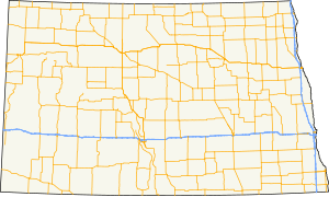
The state highways in North Dakota are the state highways owned and maintained by the North Dakota Department of Transportation (NDDOT). North Dakota is a state located in the Midwestern region of the United States, along the Canadian border. The state is bordered by Manitoba and Saskatchewan to the north, Minnesota to the east, South Dakota to the south, and Montana to the west. SignageUntil 2016 North Dakota highway signage had an "N" and a "D" in the top corners and a Native American profile, based on Lakota policeman Marcellus Red Tomahawk;[1][2] since 2016 the marker has had "North Dakota" on a black background, the state in outline, and the highway number within the state outline. This transition to new signs is a slow process that will take years before the old signs are completely out of commission. The state will be replacing the old signs as needed, so both versions can currently be seen while driving on North Dakota roads.[3] According to NDDOT, this change was made for a number of reasons. These include the department's centennial celebration, to demonstrate the significant spending to improve North Dakota roads in the past few years, and to keep uniformity across the United States, especially with online mapping providers which render individual state shields. According to an NDDOT representative, "a number of different states use their state outline or symbol on the highway signs."[4] Some also cited the North Dakota Fighting Sioux controversy as part of the reason why the state decided to change the shields, to avoid any further offense.[4] Mainline highways
Special routes
See also
References
External links
|
||||||||||||||||||||||||||||||||||||||||||||||||||||||||||||||||||||||||||||||||||||||||||||||||||||||||||||||||||||||||||||||||||||||||||||||||||||||||||||||||||||||||||||||||||||||||||||||||||||||||||||||||||||||||||||||||||||||||||||||||||||||||||||||||||||||||||||||||||||||||||||||||||||||||||||||||||||||||||||||||||||||||||||||||||||||||||||||||||||||||||||||||||||||||||||||||||||||||||||||||||||||||||||||||||||||||||||||||||||||||||||||||||||||||||||||||||||||||||||||||||||||||||||||||||||||||||||||||||||||||||||||||||||||||||||||||||||||||||||||||||||||||||||||||||||||||||||||||||||||||||||||||||||||||||||||||||||||||||||||||||||||||||||||||||||||||||||||||||||||||||||||||||||||||||||||||||||||||||||||||||||||||||||||||||||||||||||||||||||||||||||||||||||||||||||||||||||||||||||||||||||||||||||||||||||||||||||||||||||||||||||||||||||||||||||||||||||||||||||||||||||||||||||||||||||||||||
Portal di Ensiklopedia Dunia


