|
Ingalls, Oklahoma
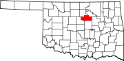
Ingalls is a census-designated place (CDP) in eastern Payne County, Oklahoma, about 9 miles (14 km) east of Stillwater. The town was settled as a result of the "Unassigned Lands" land run in 1889, and had a post office from January 22, 1890, until October 31, 1907.[3] It was named for Senator John J. Ingalls of Kansas, who was instrumental in passing legislation to open the run.[4] Around 1893, the population peaked at about 150, then began to decline by 1900.[5] History Ingalls was a peaceful community that rarely ever had any commotion, until it became notable as the site of the Battle of Ingalls on September 1, 1893, which was a shootout between U.S. Marshals and the Doolin-Dalton gang.[6] Because of this, many residents abandoned the site, claiming it would never live down its so-called reputation for harboring criminals.[7] During the oil boom in Payne County, oil was discovered on March 12, 1920, by the Mul-Berry Oil Co. on a well just east of the town. Oil was struck at just 3,000 feet, and produced 50 to 100 barrels a day. By June, Ingalls was predicted to be a major producer of oil. This breathed new life into the town.[7] Due to this activity, a new post office, named Signet, was established on a site slightly northwest of the old Ingalls townsite on June 21, 1921, and became part of a new community. The residents of the Ingalls part heavily protested, but the government refused to yield.[7] This new era of Ingalls ended as quick as it began. Oil production had declined rapidly by 1925, and residents followed the activity into other areas. By 1935, a majority of the population and businesses were gone, and the Signet post office was closed on April 30, 1935. The only positive this brought was that the few residents left changed the name back to Ingalls.[7] Another tough blow came when Highways 51 and 108 were laid, and bypassed Ingalls completely by one mile and 1 1/2 miles, respectively. Today, only a few old buildings from the town's past life are still present on the Signet site. These include the Ingalls Hotel, which was ran during the oil boom to house nearby oilfield workers, and a grocery store. Both buildings, in addition to two new ones, were used as replicas of the Pierce O.K. Hotel, Murray Saloon, Ransom Livery Stable, and Wilson General Store. They were used in reenactments of the Battle annually on September 1, until 2011, when the actors retired. On the original site, a community building stands that served as the Ingalls School in the mid-20th century, a stone monument to the US Marshals involved in the Battle stands at Ash Street, and there are many homes new and old that house families who've had ties to the community for generations. [8] Demographics
References
Sources
External links
|
||||||||||||||||||||||||||||||||||||||||||||||||||||||||||||||||||||||||||||||||||||||


Portal di Ensiklopedia Dunia