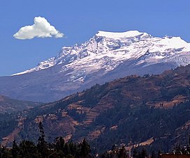
Mountain in Peru
Hualcán [ 5] [ 6] [ 7] Quechua wallqa, walqa ,[ 8] [ 9] -n a suffix ) is a mountain in the Cordillera Blanca in the Andes of Peru , about 6,165 metres (20,226 ft) high.[ 5] [ 6] Ancash , between Chacas (in Asunción Province ) and Carhuaz (Carhuaz Province ) districts.[ 10] Chequiaraju .[ 11] Huascarán National Park and it's on the border of two provinces: Asuncion and Carhuaz . Cities of Chacas and Carhuaz .[ 12]
First Ascent
Hualcan was first climbed by Karl Schmid and Siegfried Rohrer (Germany) in August 1939.[ 2] [ 3]
Elevation
Other data from available digital elevation models : SRTM yields 6157 metres[ 13] ASTER 6157 metres.[ 14] key col is 3253 meters , leading to a topographic prominence of 2912 meters .[ 15] Dominance System [ 16] parent peak is Huascaran Sur and the Topographic isolation is 13 kilometers .[ 15]
External links
References
^ "Hualcan / Rajopaquinan" . Andes Specialists . Retrieved 2020-04-12 .^ a b Deutsch-Österreichische Alpenvereins expeditionen in den Peruanischen Anden .^ a b "AAJ (American Alpine Journal)". AAJ (American Alpine Journal) : 157. 1941. ^ Neate, Jill (1994). Mountaineering in the Andes. RGS-IBG Expedition Advisory Centre, 2nd edition
^ a b Biggar, John (2005). The Andes: A Guide for Climbers . Andes. p. 77. ISBN 9780953608720 ^ a b Peru 1:100 000, Carhuás (19-h) . IGN (Instituto Geográfico Nacional - Perú).^ Alpenvereinskarte 0/3a. Cordillera Blanca Nord (Peru). 1:100 000 . Oesterreichischer Alpenverein. 2005. ISBN 3-928777-57-2 ^ Teofilo Laime Ajacopa, Diccionario Bilingüe Iskay simipi yuyayk'ancha, La Paz, 2007 (Quechua-Spanish dictionary): wallqa s. Collar. Adorno que se lleva alrededor del cuello.
^ Diccionario Quechua - Español - Quechua, Academía Mayor de la Lengua Quechua, Gobierno Regional Cusco, Cusco 2005: walqa s. Collar, collarín. || Colgandijo de oro y piedras preciosas, como la turquesa y otros, usado por la nobleza inka. || Bolsa colgante al hombro. SINÓN: wallqha, walqha. Bol: Sarta de cuentas, collar o cadena. Ec: wallka.
^ escale.minedu.gob.pe - UGEL Map of the Asunción Province (Ancash Region)
^ Biggar, John (2020). The Andes a guide for climbers ISBN 978-0-9536087-7-5 OCLC 1260820889 . {{cite book }}: CS1 maint: location missing publisher (link )^ PERU, Autor: GEO GPS. "Base de datos Perú - Shapefile - *.shp - MINAM - IGN - Límites Políticos" . Retrieved 2020-04-30 . ^ USGS, EROS Archive. "USGS EROS Archive - Digital Elevation - SRTM Coverage Maps" . Retrieved 12 April 2020 . ^ "ASTER GDEM Project" . ssl.jspacesystems.or.jp . Retrieved 2020-04-14 .^ a b "Hualcan / Rajopaquinan" . Andes Specialists . Retrieved 2020-04-12 .^ "Dominance - Page 2" . www.8000ers.com . Retrieved 2020-04-12 .
Wikimedia Commons has media related to
Hualcán .

