Egilsstaðir

Egilsstaðir
Town
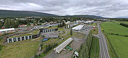
2023 view of Egilsstaðir
Location of the Municipality of Múlaþing
Egilsstaðir is located in Iceland
Egilsstaðir
Egilsstaðir
Location in Iceland
Coordinates: 65°17′N 14°23′W / 65.283°N 14.383°W / 65.283; -14.383
Country Iceland
ConstituencyNortheast Constituency
RegionEastern Region
MunicipalityMúlaþing
Population
 (2022)
 • Town2,572
 • Metro
2,955[a]
Time zoneUTC+0 (GMT)
Postal code(s)
700, 701
Websitewww.egilsstadir.is
^a including Fellabær

Egilsstaðir (Icelandic pronunciation: [ˈeijɪlsˌstaːðɪr̥]) is a town in east Iceland on the banks of the Lagarfljót river.

It is part of the municipality of Múlaþing and the largest settlement of the Eastern Region with, as of 2020, a population of 2,522 inhabitants. Formerly Egilsstaðir was part of Norður-Múlasýsla.

Overview

Egilsstadir is located at 65°17′N 14°23′W / 65.283°N 14.383°W / 65.283; -14.383. The town is young, even by Icelandic standards where urbanization is a fairly recent trend compared to mainland Europe. It was established in 1947 as an effort by the surrounding rural districts recognizing it had become a regional service centre. The town takes name from an individual farmstead and is in this respect relatively unique within the country where most or all of the towns take name from broader landmarks. It is near the bridge over Lagarfljót where all the main roads of the region meet, Route 1 as well as the main routes to the Eastern Region.

Egilsstaðir has grown to become the largest town of East Iceland and its main service, transportation, and administration centre. The town has an airport, college, and a hospital. The town grew quickly during the economic boom in the region from 2004 to 2008 associated with the building of the Kárahnjúkar Hydropower Plant and Alcoa's aluminium smelting plant in Reyðarfjörður. The growth has slowed markedly since the banking collapse in 2008.

History

In written accounts, Egilsstaðir is first mentioned in the 15th century as a place for legislative assembly. Nothing is therefore known with certainty about the individual person Egil lending it its name, the only conjecture to this effect met with in books detailing the story of the town is that it may be named after Egil Síðu-Hallsson, but Hallr at Síða was a captain in the east and an uncle to Rollo in France, but this guess is of controlled probability and most likely the person left no other recort of himself. The nearby river Eyvindará is mentioned in the Saga of the Sons of Droplaug and Saga of the inhabitants of Fljótsdalur.

Urbanization in Egilsstaðir can be traced to Jón Bergsson (1855–1923), a farmer, who laid the groundwork for increased commerce and services at the Egilsstaðir farm by erecting a large residential building there at the start of the 20th century. The house is still in use as a hotel. Jón bought the farm Egilsstaðr at the close of the 19th century because of its location when he predicted "Crossroads will be here", which proved prescient.[1] Along with others, Jón Bergsson also took the initiative to establish the co-operative Kaupfélag Héraðsbúa (KHB) with headquarters there in 1909.[2] [3] In subsequent years, bridges were built over Lagarfljót river and Eyvindará river and a road made over Fagridalur to Reyðarfjörður. Later, the regional headquarters for mail and telephone services were located at Egilsstaðir.[4]

Nielsenshus, oldest private house in Egilsstaðir, built in 1944

In 1947 Egilsstaðir was incorporated as a town and a rural jurisdiction Egilsstaðahreppur, with neighbouring jurisdictions Vallahreppur and Eiðahreppur joining the new jurisdiction. The town soon grew and by 1980 the population exceeded 1000. In 1987, the status of the town was upgraded to kaupstaður and renamed Egilsstaðabær, or the town of Egilsstaðir. In early 2011, the population was 2,257 and had increased by 41 percent from 2001, when 1,600 were registered there.[5]

On 7 June 1998 Egilsstaðabær was united with Vallahreppur, Skriðdalshreppur, Eiðahreppur and Hjaltastaðarhreppur under the name Austur-Hérað. Austur-Hérað then became Fljótsdalshérað in 2004. In 2020 it joined other municipalities to form Múlaþing.

Climate

Depending on isotherm Egilsstaðir has a subarctic climate (Köppen: Dfc) or a subpolar oceanic climate (Cfc) bordering very closely on a Tundra climate (ET). Winters there tend to be colder than other towns in the area, and summers tend to have daytime highs often exceeding 15 °C (59 °F), higher than most of Iceland, but at night it is colder than most towns with a similar climate. The town being at a relatively low elevation somewhat shielded from maritime winds enables warmer air to stay for longer than in coastal areas, although the effect of southerlies become negated by high mountains blocking such winds, and as a result Egilsstaðir still has a lot cooler summers than continental Nordic climates have on similar latitudes. Egilsstaðir being relatively close to the east coast also increased the maritime moderation both in summer and winter. With Central Iceland being at a highland tundra, the Egilsstaðir area is still the warmest for 1961–1990 summer maxima among Icelandic weather stations for populated areas.

The figures here given for precipitation days and sunshine hours belong to Grímsárvirkjun and Hallormsstaður, which are 15 kilometres (9 mi) and 25 kilometres (16 mi) away from Egilsstaðir respectively and get around 100 millimetres (4 in) more precipitation than Egilsstaðir, so it is possible that Egilsstaðir has fewer days with precipitation and gets more sunlight than stated below. The highest temperature recorded is 29.2 °C (84.6 °F) on 11 August 2004, recorded at Egilsstaðir Airport.[6]

Climate data for Egilsstaðir (1961–1990)
Month Jan Feb Mar Apr May Jun Jul Aug Sep Oct Nov Dec Year
Record high °C (°F) 14.2
(57.6)
12.5
(54.5)
14.5
(58.1)
18.5
(65.3)
25.0
(77.0)
26.7
(80.1)
28.8
(83.8)
29.2
(84.6)
21.9
(71.4)
18.9
(66.0)
13.8
(56.8)
14.0
(57.2)
29.2
(84.6)
Mean daily maximum °C (°F) 0.7
(33.3)
1.4
(34.5)
2.2
(36.0)
5.0
(41.0)
8.9
(48.0)
13.1
(55.6)
14.8
(58.6)
13.9
(57.0)
10.0
(50.0)
6.0
(42.8)
2.3
(36.1)
1.2
(34.2)
6.6
(43.9)
Daily mean °C (°F) −2.4
(27.7)
−1.9
(28.6)
−1.4
(29.5)
1.2
(34.2)
4.8
(40.6)
8.7
(47.7)
10.3
(50.5)
9.6
(49.3)
6.2
(43.2)
3.1
(37.6)
−0.7
(30.7)
−2.2
(28.0)
2.9
(37.3)
Mean daily minimum °C (°F) −5.8
(21.6)
−5.3
(22.5)
−4.4
(24.1)
−2.0
(28.4)
1.4
(34.5)
5.0
(41.0)
6.6
(43.9)
6.2
(43.2)
3.2
(37.8)
0.4
(32.7)
−3.8
(25.2)
−5.3
(22.5)
−0.3
(31.5)
Record low °C (°F) −24.0
(−11.2)
−22.1
(−7.8)
−26.7
(−16.1)
−21.4
(−6.5)
−10.8
(12.6)
−4.5
(23.9)
−0.5
(31.1)
−2.7
(27.1)
−6.8
(19.8)
−14.4
(6.1)
−19.4
(−2.9)
−22.5
(−8.5)
−26.7
(−16.1)
Average precipitation mm (inches) 70.5
(2.78)
50.3
(1.98)
62.0
(2.44)
39.5
(1.56)
27.8
(1.09)
27.6
(1.09)
39.8
(1.57)
41.4
(1.63)
67.7
(2.67)
76.5
(3.01)
54.9
(2.16)
60.6
(2.39)
618.6
(24.37)
Average precipitation days (≥ 0.1 mm) 14.7 11.9 13.6 10.4 9.4 10.1 11.6 12.5 13.7 14.5 13.1 14.0 149.5
Average relative humidity (%) 83 82 82 79 78 75 79 80 81 83 83 83 81
Mean monthly sunshine hours 0.6 33.5 84.2 142.5 182.4 187.3 172.9 145.7 86.1 46.2 6.4 0 1,087.8
Source 1: Icelandic Met Office (extremes 1955–97, humidity 1963–90, sun 1960–89 for Hallormsstaður-25 km (15 mi) from Egilsstaðir)[7][8]
Source 2: Icelandic Met Office (precipitation days 1961–90 for Grímsárvirkjun-15 km (9 mi) from Egilsstaðir)[9]

The climate has significantly warmed in recent years, as seen in the climate averages for the 1991–2020 reference period.

Climate data for Egilsstaðir (1991–2020)
Month Jan Feb Mar Apr May Jun Jul Aug Sep Oct Nov Dec Year
Daily mean °C (°F) −0.9
(30.4)
−1.0
(30.2)
−0.3
(31.5)
2.0
(35.6)
5.5
(41.9)
9.5
(49.1)
10.7
(51.3)
10.4
(50.7)
7.8
(46.0)
3.7
(38.7)
0.6
(33.1)
−1.1
(30.0)
3.8
(38.8)
Source: Icelandic Met Office[10]

Points of interest

View of Egilsstaðir

Notable natives

References

  1. ^ "Um sögu Egilsstaðabæjar" (in Icelandic). Archived from the original on 20 March 2012. Retrieved 30 May 2011.
  2. ^ "Pöntunarfjelag Fljótsdalshéraðs" (in Icelandic). Retrieved 30 May 2011.
  3. ^ "Austur-Hérað" (in Icelandic). Retrieved 30 May 2011.
  4. ^ "Austri, 17. janúar 1903, 13. árg., 2. tbl" (in Icelandic). Archived from the original on 26 July 2011. Retrieved 30 May 2011.
  5. ^ "Hagstofa Íslands, mannfjöldi" (in Icelandic). Retrieved 30 May 2011.
  6. ^ "Hæsti hiti á Íslandi – Teigarhorn 22. júní 1939". Icelandic Meteorological Office. Retrieved 11 February 2017.
  7. ^ "Climatological Data for Egilsstaðir". Icelandic Meteorological Office. Retrieved 19 November 2016.
  8. ^ "Climatological Data for Hallormsstaður". Icelandic Meteorological Office. Retrieved 19 November 2016.
  9. ^ "1961–90 Precipitation Averages for Grímsárvirkjun". Icelandic Meteorological Office. Retrieved 19 November 2016.
  10. ^ "Fréttir". Icelandic Meteorological Office. Retrieved 11 August 2022.

Read other articles:

For the engineering term, see Angle of repose. 1971 novel by Wallace Stegner Angle of Repose First edition coverAuthorWallace StegnerCountryUnited StatesLanguageEnglishPublisherDoubledayPublication date1971Media typePrint (hardback & paperback)ISBN0-14-016930-XOCLC24953754Dewey Decimal813/.52 20LC ClassPS3537.T316 A8 1992 Angle of Repose is a 1971 novel by Wallace Stegner about a wheelchair-using historian, Lyman Ward, who has lost connection with his son and living family and deci…

Art museum in Seattle, Washington, United States Seattle Art MuseumEarlier entrance to the Seattle Art Museum (prior to its 2007 expansion)Location within downtown SeattleEstablished1933Location1300 First Avenue, Seattle, Washington, U.S.Coordinates47°36′26″N 122°20′17″W / 47.6072°N 122.3381°W / 47.6072; -122.3381TypeArt MuseumCollection size25,000Visitors750,000+ annually (all locations)[1]DirectorAmada CruzPublic transit access University Street stat…

この記事は検証可能な参考文献や出典が全く示されていないか、不十分です。出典を追加して記事の信頼性向上にご協力ください。(このテンプレートの使い方)出典検索?: コルク – ニュース · 書籍 · スカラー · CiNii · J-STAGE · NDL · dlib.jp · ジャパンサーチ · TWL(2017年4月) コルクを打ち抜いて作った瓶の栓 コルク(木栓、蘭&…

Penguin BooksLogo Stato Regno Unito Fondazione1935 a Londra Fondata daAllen Lane Sede principaleLondra GruppoPenguin Random House SettoreEditoria ProdottiLibri Sito webpenguin.co.uk/ Modifica dati su Wikidata · Manuale La Penguin Books è una casa editrice britannica, attualmente parte del gruppo Penguin Random House, originariamente fondata nel 1935 da Allen Lane. È diventata famosa per aver rivoluzionato il mercato editoriale con l'invenzione dei tascabili: romanzi di buona qua…

Untuk tempat lain yang bernama sama, lihat Sidomukti (disambiguasi). SidomuktiKelurahanNegara IndonesiaProvinsiJawa TimurKabupatenGresikKecamatanKebomasKodepos61123Kode Kemendagri35.25.14.1008 Kode BPS3525090014 Luas... km²Jumlah penduduk... jiwaKepadatan... jiwa/km² Prajurit dari 24th Indian Mountain Battery, 5th Indian Division mengambil posisi dekat Sidomukti pada masa pertempuran Surabaya Sidomukti adalah kelurahan yang berada di kecamatan Kebomas, Kabupaten Gresik, Jawa Timur, Indone…

Sup Yusup (13 Desember 1939 – 18 September 2011) adalah pelawak senior Indonesia.[1][2] Ia terkenal dalam perannya sebagai tokoh komedi di film Indonesia era 1970 dan 1980-an. Selain itu ia pernah bergabung singkat dalam acara Ria Jenaka yang ditayangkan TVRI pada era 1980-an. Riwayat hidup Sup Yusup adalah salah satu dari sekian seniman asal Kota Bandung ataupun Jawa Barat yang membawakan lawakan dengan kekhasannya yang Nyunda. Selain Sup Yusup, karakter orang Su…

Flame-resistant meta-aramid material A firefighter in Toronto, Canada wears a Nomex hood in 2007. Nomex is a flame-resistant meta-aramid material developed in the early 1960s by DuPont and first marketed in 1967.[1] Properties Nomex and related aramid polymers are related to nylon, but have aromatic backbones, and hence are more rigid and more durable. Nomex is an example of a meta variant of the aramids (Kevlar is a para aramid). Unlike Kevlar, Nomex strands cannot align during filament…

Северный морской котик Самец Научная классификация Домен:ЭукариотыЦарство:ЖивотныеПодцарство:ЭуметазоиБез ранга:Двусторонне-симметричныеБез ранга:ВторичноротыеТип:ХордовыеПодтип:ПозвоночныеИнфратип:ЧелюстноротыеНадкласс:ЧетвероногиеКлада:АмниотыКлада:Синапсиды…

周處除三害The Pig, The Snake and The Pigeon正式版海報基本资料导演黃精甫监制李烈黃江豐動作指導洪昰顥编剧黃精甫主演阮經天袁富華陳以文王淨李李仁謝瓊煖配乐盧律銘林孝親林思妤保卜摄影王金城剪辑黃精甫林雍益制片商一種態度電影股份有限公司片长134分鐘产地 臺灣语言國語粵語台語上映及发行上映日期 2023年10月6日 (2023-10-06)(台灣) 2023年11月2日 (2023-11-02)(香港、…

The Spanish fly, Lytta vesicatoria, has been considered to have medicinal, aphrodisiac, and other properties. Human interactions with insects include both a wide variety of uses, whether practical such as for food, textiles, and dyestuffs, or symbolic, as in art, music, and literature, and negative interactions including damage to crops and extensive efforts to control insect pests. Academically, the interaction of insects and society has been treated in part as cultural entomology, dealing most…

US Air Force base at Sumter, South Carolina, United States Shaw Air Force BaseSumter, South Carolina in United StatesA General Dynamics F-16 Fighting Falcon of the 77th Fighter Squadron, part of the 20th Fighter Wing based at Shaw AFBShaw AFBShow map of North AmericaShaw AFBShow map of North AtlanticShaw AFBShow map of the United StatesShaw AFBShow map of South CarolinaCoordinates33°58′23″N 080°28′22″W / 33.97306°N 80.47278°W / 33.97306; -80.47278TypeUS A…

  لمعانٍ أخرى، طالع صول (توضيح). 8°23′46″N 47°41′29″E / 8.39611°N 47.69139°E / 8.39611; 47.69139 صول     الإحداثيات 8°23′46″N 47°41′29″E / 8.3961111111111°N 47.691388888889°E / 8.3961111111111; 47.691388888889   تاريخ التأسيس العقد 1980  تقسيم إداري  البلد الصومال[1]  العاصمة لاس عانود…

François Etienne de KellermannGeneral Kellermann, Adipati Valmy ke-2Lahir(1770-08-04)4 Agustus 1770Metz, PrancisMeninggal2 Juni 1835(1835-06-02) (umur 64)Paris, PrancisPengabdian Kerajaan Prancis Republik Pertama Prancis Kekaisaran Prancis PertamaDinas/cabangAngkatan Darat PrancisLama dinas1785–1795–1815PangkatJenderal DivisiPenghargaanNama diukir di bawah Arc de TriomphePekerjaan lainpolitikus François Étienne de Kellermann, Duc de Valmy ke-2 (4 Agustus 1770…

United States federal district court in Florida United States District Court for the Southern District of Florida(S.D. Fla.)LocationWilkie D. Ferguson, Jr. U.S. Courthouse(Miami)More locationsC. Clyde Atkins U.S. Courthouse(Miami)James L. King Federal Justice Building(Miami)Fort LauderdaleWest Palm BeachFort PierceSidney M. Aronovitz United States Courthouse(Key West)Appeals toEleventh CircuitEstablishedFebruary 23, 1847Judges18Chief JudgeCecilia AltonagaOfficers of the courtU.S. …

Space-filling curve First six iterations of the Hilbert curve The Hilbert curve (also known as the Hilbert space-filling curve) is a continuous fractal space-filling curve first described by the German mathematician David Hilbert in 1891,[1] as a variant of the space-filling Peano curves discovered by Giuseppe Peano in 1890.[2] Because it is space-filling, its Hausdorff dimension is 2 (precisely, its image is the unit square, whose dimension is 2 in any definition of dimension; i…

Clarence Fahnestock Memorial State ParkCanopus Lake in Fahnestock Memorial State ParkLocation of Clarence Fahnestock Memorial State Park within New York StateTypeState parkLocation1498 Route 301 Carmel, New York[1]Nearest cityCarmel, New YorkCoordinates41°25′44″N 73°51′29″W / 41.429°N 73.858°W / 41.429; -73.858Area14,337 acres (58.02 km2)[2]Created1929 (1929)Operated byNew York State Office of Parks, Recreation and Historic …

This article is about the geographic region. For the NSW state electoral district, see Electoral district of North Shore. Not to be confused with Northern Beaches or North Sydney (disambiguation). Region in New South Wales, AustraliaNorth ShoreSydney, New South WalesSydney Harbour with the North Shore extending from its northern side (right) with Sydney CBD (left) and Eastern Suburbs (bottom) on its southern shore.North ShoreApproximate centre of the North Shore in SydneyCoordinates33°47…

LVTP-5 LVTP-5类型兩棲裝甲運兵車原产地 美国服役记录服役期间1952-参与战争/衝突1958年黎巴嫩危機越戰生产历史研发者博格華納研发日期1950-1951制造数量1124基本规格重量37.4公噸长度9.04公尺宽度3.57公尺高度2.92公尺操作人数3+34 乘員装甲6-16公厘的鋼質裝甲主武器M1919A4機槍(A、A1)、白朗寧M2重機槍(A1與其他款式)、M240通用機槍(LVTH-6)、M49 24倍徑105mm榴彈炮(LVTH-6)、工蜂四型(LVTP-5-RL…

American music company KidinakornerParent companyInterscope Geffen A&MFounded2011 (2011)FounderAlexander GrantDistributor(s)Interscope Geffen A&M (United States)Universal Music Group(International)GenreVariousCountry of originUnited StatesLocationLos Angeles, California Kidinakorner (stylized as KIDinaKORNER) is an American record company founded in 2011 by British music producer and songwriter Alexander Alex da Kid Grant. The company houses a record label, music publishing, commerc…

For other lists, see List of mountain peaks of the United States and List of mountain peaks of North America. This article's use of external links may not follow Wikipedia's policies or guidelines. Please improve this article by removing excessive or inappropriate external links, and converting useful links where appropriate into footnote references. (April 2023) (Learn how and when to remove this message) This list includes significant mountain peaks located in the United States arranged alphab…