|
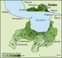
Dollart The Dollart (German name, pronounced [ˈdɔlaʁt]) or Dollard (Dutch name, pronounced [ˈdɔlɑrt]) is a bay in the Wadden Sea between the northern Netherlands and Germany, on the west side of the estuary of the Ems river. Most of it dries at low tide. Many water birds feed there. Gaining from and losing to the sea According to legend, the Dollart Bay was created by a catastrophic storm surge in 1277,[1] covering the district of Rheiderland and large parts of the Oldambt district. The flood was rumoured to have caused 80,000 deaths.[2] The story, however, is not true and based on legend instead of facts.[3][4][5] The Dollart was created as a slow inundation over many centuries[6] which accumulated in a storm surge in 1509. The 1509 surge extended the Dollart, and flooded 30 more villages,[5] and by 1520 the Dollart had its largest extension. Between the 16th and the 20th centuries, two thirds of the drowned area was reclaimed. Nowadays the unembanked forelands have been declared world natural heritage, as they are a paradise for all kinds of birds and other aquatic species.[7] Border dispute The Netherlands and Germany do not agree on the exact course of the border through the bay,[8] yet they have agreed to disagree by signing a treaty in 1960, laying out mutual responsibilities.[9] Around 2011, the territorial dispute gained relevance with plans for the Borkum Riffgat offshore wind farm.[10] The question about use and administration of the territorial waters between 3 and 12 nautical miles (where the wind farm is located) was settled with another treaty in 2014 by defining a "line", while the border dispute itself remained unresolved.[11] Literature
References
External links
|
Portal di Ensiklopedia Dunia
