Admire, Kansas

Admire, Kansas
Aerial view of Admire (2013)
Location within Lyon County and Kansas
KDOT map of Lyon County (legend)
Coordinates: 38°38′28″N 96°06′07″W / 38.64111°N 96.10194°W / 38.64111; -96.10194[1]
CountryUnited States
StateKansas
CountyLyon
Founded1886
Incorporated1916 [2]
Named forJacob Admire
Government
 • TypeMayor–Council
Area
 • Total0.32 sq mi (0.84 km2)
 • Land0.32 sq mi (0.84 km2)
 • Water0.00 sq mi (0.00 km2)
Elevation1,234 ft (376 m)
Population
 • Total130
 • Density410/sq mi (150/km2)
Time zoneUTC-6 (CST)
 • Summer (DST)UTC-5 (CDT)
ZIP code
66830
Area code620
FIPS code20-00325
GNIS ID2393883[1]
Websiteadmireks.com

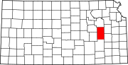
Admire is a city in Lyon County, Kansas, United States.[1] As of the 2020 census, the population of the city was 130.[4]

History

Admire was founded in 1886.[5] It was named for one of its founders, Jacob Admire.[6]

The first post office in Admire was established in November 1886.[7]

Admire was a station and shipping point on the Missouri Pacific Railroad.[8] By the mid 1990s, rail service in Admire had been discontinued, and the tracks are now being used as a rail trail.[9]

Admire's current acting mayor is Donna Uhl. The former mayor, prior to January 2024, was Robert Reust.

Geography

According to the United States Census Bureau, the city has a total area of 0.33 square miles (0.85 km2), all land.[10]

Demographics

Historical population
CensusPop.Note
1920205
193026328.3%
19402702.7%
1950184−31.9%
1960149−19.0%
1970144−3.4%
19801589.7%
1990147−7.0%
200017720.4%
2010156−11.9%
2020130−16.7%
U.S. Decennial Census

Admire is part of the Emporia Micropolitan Statistical Area.

2020 census

The 2020 United States census counted 130 people, 48 households, and 38 families in Admire.[11][12] The population density was 402.5 per square mile (155.4/km2). There were 59 housing units at an average density of 182.7 per square mile (70.5/km2).[12][13] The racial makeup was 95.38% (124) white or European American (85.38% non-Hispanic white), 0.0% (0) black or African-American, 3.08% (4) Native American or Alaska Native, 0.0% (0) Asian, 0.0% (0) Pacific Islander or Native Hawaiian, 0.77% (1) from other races, and 0.77% (1) from two or more races.[14] Hispanic or Latino of any race was 10.77% (14) of the population.[15]

Of the 48 households, 37.5% had children under the age of 18; 62.5% were married couples living together; 10.4% had a female householder with no spouse or partner present. 14.6% of households consisted of individuals and 8.3% had someone living alone who was 65 years of age or older.[12] The average household size was 2.3 and the average family size was 2.7.[16] The percent of those with a bachelor’s degree or higher was estimated to be 10.8% of the population.[17]

23.1% of the population was under the age of 18, 11.5% from 18 to 24, 21.5% from 25 to 44, 27.7% from 45 to 64, and 16.2% who were 65 years of age or older. The median age was 39.5 years. For every 100 females, there were 106.3 males.[12] For every 100 females ages 18 and older, there were 122.2 males.[12]

The 2016-2020 5-year American Community Survey estimates show that the median household income was $45,529 (with a margin of error of +/- $2,699) and the median family income was $46,200 (+/- $8,733).[18] Males had a median income of $31,202 (+/- $1,315) versus $15,600 (+/- $3,906) for females.[19] Approximately, 6.9% of families and 10.7% of the population were below the poverty line, including 31.6% of those under the age of 18 and 0.0% of those ages 65 or over.[20][21]

2010 census

As of the census[22] of 2010, there were 156 people, 60 households, and 43 families living in the city. The population density was 472.7 inhabitants per square mile (182.5/km2). There were 70 housing units at an average density of 212.1 per square mile (81.9/km2). The racial makeup of the city was 95.5% White, 0.6% from other races, and 3.8% from two or more races. Hispanic or Latino of any race were 7.1% of the population.

There were 60 households, of which 33.3% had children under the age of 18 living with them, 60.0% were married couples living together, 8.3% had a female householder with no husband present, 3.3% had a male householder with no wife present, and 28.3% were non-families. 28.3% of all households were made up of individuals, and 15% had someone living alone who was 65 years of age or older. The average household size was 2.60 and the average family size was 3.16.

The median age in the city was 32.5 years. 26.3% of residents were under the age of 18; 9% were between the ages of 18 and 24; 23.1% were from 25 to 44; 25.7% were from 45 to 64; and 16% were 65 years of age or older. The gender makeup of the city was 47.4% male and 52.6% female.

2000 census

As of the census[23] of 2000, there were 177 people, 67 households, and 47 families living in the city. The population density was 534.5 inhabitants per square mile (206.4/km2). There were 73 housing units at an average density of 220.4 per square mile (85.1/km2). The racial makeup of the city was 95.48% White, 0.56% Native American, 0.56% from other races, and 3.39% from two or more races. 1.13% of the population were Hispanic or Latino of any race.

There were 67 households, out of which 37.3% had children under the age of 18 living with them, 62.7% were married couples living together, 6.0% had a female householder with no husband present, and 28.4% were non-families. 26.9% of all households were made up of individuals, and 11.9% had someone living alone who was 65 years of age or older. The average household size was 2.64 and the average family size was 3.17.

In the city, the population was spread out, with 28.2% under the age of 18, 11.3% from 18 to 24, 29.4% from 25 to 44, 20.9% from 45 to 64, and 10.2% who were 65 years of age or older. The median age was 34 years. For every 100 females, there were 90.3 males. For every 100 females age 18 and over, there were 92.4 males.

The median income for a household in the city was $40,250, and the median income for a family was $47,250. Males had a median income of $26,406 versus $18,750 for females. The per capita income for the city was $15,666. About 3.9% of families and 4.4% of the population were below the poverty line, including 4.9% of those under the age of eighteen and none of those 65 or over.

Education

The community is served by North Lyon County USD 251 public school district, and its headquarters are located in Americus. The Northern Heights High School is located east of Allen, and its mascot is the Wildcats. The NLC Elementary School and NLC Early Learning Center (preschool) are located in Americus.

Currently, there is no elementary school in Admire; the old elementary school building has been converted into the Admire Community Center.

Transportation

U.S. Route 56 is located approximately 0.5 miles (0.80 km) north of Admire. The closest Kansas Turnpike exit is located approximately 3.5 miles (5.6 km) east of Admire along U.S. Route 56.

Notable person

References

  1. ^ a b c d U.S. Geological Survey Geographic Names Information System: Admire, Kansas
  2. ^ a b "City of Admire". The League of Kansas Municipalities. May 24, 2019.
  3. ^ "2019 U.S. Gazetteer Files". United States Census Bureau. Retrieved July 24, 2020.
  4. ^ a b "Profile of Admire, Kansas in 2020". United States Census Bureau. Archived from the original on May 3, 2022. Retrieved May 3, 2022.
  5. ^ Kansas State Historical Society (1916). Biennial Report of the Board of Directors of the Kansas State Historical Society. Kansas State Printing Plant. pp. 228.
  6. ^ French, Laura M. (1929). History of Emporia and Lyon County, Kansas. Heritage Books. p. 140. ISBN 9780788403460.
  7. ^ "Kansas Post Offices, 1828-1961". Kansas Historical Society. Retrieved June 10, 2014.
  8. ^ Blackmar, Frank Wilson (1912). Kansas: A Cyclopedia of State History, Embracing Events, Institutions, Industries, Counties, Cities, Towns, Prominent Persons, Etc. Standard Publishing Company. pp. 26.
  9. ^ "Kansas' Flint Hills Nature Trail". Rails-to-Trails Conservancy. Retrieved March 27, 2014.
  10. ^ "US Gazetteer files 2010". United States Census Bureau. Archived from the original on January 25, 2012. Retrieved July 6, 2012.
  11. ^ "US Census Bureau, Table P16: HOUSEHOLD TYPE". data.census.gov. Retrieved December 31, 2023.
  12. ^ a b c d e "US Census Bureau, Table DP1: PROFILE OF GENERAL POPULATION AND HOUSING CHARACTERISTICS". data.census.gov. Retrieved December 31, 2023.
  13. ^ Bureau, US Census. "Gazetteer Files". Census.gov. Retrieved December 30, 2023.
  14. ^ "US Census Bureau, Table P1: RACE". data.census.gov. Retrieved December 31, 2023.
  15. ^ "US Census Bureau, Table P2: HISPANIC OR LATINO, AND NOT HISPANIC OR LATINO BY RACE". data.census.gov. Retrieved December 31, 2023.
  16. ^ "US Census Bureau, Table S1101: HOUSEHOLDS AND FAMILIES". data.census.gov. Retrieved December 31, 2023.
  17. ^ "US Census Bureau, Table S1501: EDUCATIONAL ATTAINMENT". data.census.gov. Retrieved December 31, 2023.
  18. ^ "US Census Bureau, Table S1903: MEDIAN INCOME IN THE PAST 12 MONTHS (IN 2020 INFLATION-ADJUSTED DOLLARS)". data.census.gov. Retrieved December 31, 2023.
  19. ^ "US Census Bureau, Table S2001: EARNINGS IN THE PAST 12 MONTHS (IN 2020 INFLATION-ADJUSTED DOLLARS)". data.census.gov. Retrieved January 2, 2024.
  20. ^ "US Census Bureau, Table S1701: POVERTY STATUS IN THE PAST 12 MONTHS". data.census.gov. Retrieved December 31, 2023.
  21. ^ "US Census Bureau, Table S1702: POVERTY STATUS IN THE PAST 12 MONTHS OF FAMILIES". data.census.gov. Retrieved December 31, 2023.
  22. ^ "U.S. Census website". United States Census Bureau. Retrieved July 6, 2012.
  23. ^ "U.S. Census website". United States Census Bureau. Retrieved January 31, 2008.

Further reading

Read other articles:

Commuter rail station in Prospect Heights, Illinois Prospect HeightsProspect Heights station in June 2021.General informationLocation55 South Wolf RoadProspect Heights, IllinoisCoordinates42°05′32″N 87°54′29″W / 42.0923°N 87.9080°W / 42.0923; -87.9080Owned byMetraPlatforms2 side platformsTracks2Connections Pace BusesConstructionAccessibleYesOther informationFare zone3HistoryOpenedAugust 19, 1996[1]Passengers2018304 (average weekday)[2]Q…

Roman Catholic church in Las Piñas, Philippines Church in Metro Manila, PhilippinesLas Piñas ChurchSaint Joseph ParishBamboo Organ ChurchIglesia Parroquial de San José de Las Piñas, Iglesia del Órgano de Bambú (Spanish)The church in November 2023Las Piñas ChurchLocation in ManilaShow map of ManilaLas Piñas ChurchLocation in Metro ManilaShow map of Metro ManilaLas Piñas ChurchLocation in LuzonShow map of LuzonLas Piñas ChurchLocation in the PhilippinesShow map of Philippines14°28…

Canadian national day National Acadian Day in 1909, Shediac, New Brunswick Celebration of National Acadian Day in Fredericton, New Brunswick, with a traditional tintamarre and Acadian flags The National Acadian Day (French: Fête nationale de l'Acadie) is observed in parts of Canada each year on August 15, to celebrate Acadian culture. It was during the first National Convention of the Acadians held at Memramcook, New Brunswick, in 1881 that the Acadian leaders received the mandate to set the da…

Société internationale des amis de MontaigneLogo.HistoireFondation 1er août 2000CadreType Laboratoire d’idéesForme juridique Association déclaréeDomaine d'activité GénéralisteFinancement PrivéMéthode LobbyingSiège Paris (59, rue La Boétie, 75008)Pays  FranceOrganisationFondateur Claude BébéarPrésident Henri de Castries (depuis 2015)Directrice Marie-Pierre de Bailliencourt (d) (depuis 2022)Idéologie LibéralismeBudget 7 280 000 € (2021)Publication Notes, études, rapport…

Letak Moji-ku di Kitakyūshū Stasiun Mojiko Moji-ku (門司区code: ja is deprecated ) adalah sebuah kawasan Jepang di kota Kitakyūshū, Prefektur Fukuoka. Kawasan tersebut merupakan bekas kota Moji yang merupakan salah satu dari lima kota yang digabung untuk membuat Kitakyūshū pada 1963. Kawasan tersebut menghadap kota Shimonoseki yang berada di seberang Selat Kanmon antara Honshū dan Kyūshū. Kawasan tersebut memiliki wilayah seluas 73.37 km² dan memiliki penduduk sejumlah 114,754 …

This article needs additional citations for verification. Please help improve this article by adding citations to reliable sources. Unsourced material may be challenged and removed.Find sources: Barriopedro – news · newspapers · books · scholar · JSTOR (April 2024) (Learn how and when to remove this message) Place in Castile-La Mancha, SpainBarriopedroBarriopedroShow map of Province of GuadalajaraBarriopedroShow map of Castilla-La ManchaBarriopedroShow ma…

Questa voce sull'argomento cestisti statunitensi è solo un abbozzo. Contribuisci a migliorarla secondo le convenzioni di Wikipedia. Segui i suggerimenti del progetto di riferimento. Lonnie Walker Walker in azione al McDonald's All-American Game del 2017 Nazionalità  Stati Uniti Altezza 193 cm Peso 89 kg Pallacanestro Ruolo Guardia Squadra  Brooklyn Nets CarrieraGiovanili ?-2017Reading High School2017-2018 Miami HurricanesSquadre di club 2018-2022 San Antonio Spurs208 (…

United Nations resolution adopted in 2006 UN Security CouncilResolution 1730United Nations emblemDate19 December 2006Meeting no.5,599CodeS/RES/1730 (Document)SubjectGeneral issues relating to sanctionsVoting summary15 voted forNone voted againstNone abstainedResultAdoptedSecurity Council compositionPermanent members China France Russia United Kingdom United StatesNon-permanent members Argentina Rep. of the Congo Denmark Ghana Greece Jap…

1930 painting by Piet Mondrian Composition with Red, Blue and YellowArtistPiet MondrianYear1930TypeOil on canvasDimensions45 cm × 45 cm (17.7165 in × 17.7165 in)LocationKunsthaus Zürich Composition with Red, Blue and Yellow is a 1930 painting[1] by Piet Mondrian, a Dutch artist who was a leading figure in the Neo-Plasticism movement. It consists of thick, black brushwork, defining the borders of colored rectangles. As the title suggests, the o…

Monte Cassino, Altar Basilika Richard dari San Germano (bahasa Italia: Riccardo; seb. 1170 – set. Oktober 1243) merupakan seorang notaris di biara Montecassino, di San Germano pada waktu itu, di Valle Latina, dari Februari 1186 hingga Maret 1232. Dia menulis sebuah kronik (kadang-kadang Chronica regni Siciliae) Mezzogiorno dari kematian Gugghiermu II dari Sisilia pada tahun 1189 hingga 1243. Ini adalah sumber informasi paling lengkap tentang Hohenstaufen di Italia. Riccardo adalah pendampi…

District in Hokkaidō, Japan The area of Tokachi District in Tokachi SubprefectureThis article needs additional citations for verification. Please help improve this article by adding citations to reliable sources. Unsourced material may be challenged and removed.Find sources: Tokachi District, Hokkaido – news · newspapers · books · scholar · JSTOR (October 2023) (Learn how and when to remove this message) Tokachi District (十勝郡, Tokachi-gun) is a dis…

Type of business industry usually conducted over the internet E-commerce Digital content Ebook Software Streaming media Retail goods and services Advertising Auctions Banking DVD-by-mail Distribution Food ordering Grocery Marketplace Pharmacy Ride-hailing Travel Online shopping Comparison shopping Social commerce Trading communities Wallet Mobile commerce Payment Ticketing Customer service Call centre Help desk Live support software E-procurement Purchase-to-pay Super-appsvte E-commerce (electro…

Belief or theory that is strongly at variance with established belief or customs Not to be confused with hearsay. Heretic, heretical, and heresies redirect here. For the website, see Heretical (website). For other uses, see Heretic (disambiguation) and Heresy (disambiguation). The Gospel triumphs over Heresia and the Serpent. Gustaf Vasa Church, Stockholm, Sweden, sculpture by Burchard Precht. A statue in Vienna portraying Saint Ignatius of Loyola trampling on a heretic The burning of the panthe…

Cycling race 2009 Tour de Suisse2009 UCI World Ranking, race 16 of 24Race detailsDates13–21 June 2009Stages9Distance1,353.4[1] km (841.0 mi)Winning time33h 05' 51Results Winner  Fabian Cancellara (SUI) (Team Saxo Bank)  Second  Tony Martin (GER) (Team Columbia–High Road)  Third  Roman Kreuziger (CZE) (Liquigas) Points  Fabian Cancellara (SUI) (Team Saxo Bank) Mountains  Tony Martin (GER) (Team Columbia–High R…

Gold Coast Hockey CentreGold Coast Hockey CentreCoordinates27°57′15″S 153°23′38″E / 27.95423757820048°S 153.3939298893625°E / -27.95423757820048; 153.3939298893625Genre(s)field hockeySurfaceAstroturfTenantsGold Coast Hockey AssociationLabrador Hockey ClubWebsitewww.gchmg.org Gold Coast Hockey Centre is a hockey stadium in Gold Coast, Queensland, Australia. The venue was renovated to host the men's and women's hockey event of the 2018 Commonwealth Games. It was…

Dưới đây là những quả bóng đã được sử dụng trong gmôn bóng đá của Thế vận hội Mùa hè. Danh sách này không đầy đủ; bạn có thể giúp đỡ bằng cách mở rộng nó. Thế vận hội Bóng đá chính thức Nhà chế tạo Thông tin thêm Thế vận hội 1968 Thế vận hội 1972 Thế vận hội 1976 Thế vận hội 1980 Thế vận hội 1984 Adidas Tango Sevilla Adidas Thế vận hội 1988 Adidas Tango Séoul Adidas Thế vận h…

Election in Louisiana Main article: 1972 United States presidential election 1972 United States presidential election in Louisiana ← 1968 November 7, 1972 1976 →   Nominee Richard Nixon George McGovern Party Republican Democratic Home state California South Dakota Running mate Spiro Agnew Sargent Shriver Electoral vote 10 0 Popular vote 686,852 298,142 Percentage 65.32% 28.35% Parish Results Nixon   40-50%   50-60%   60…

إمبراطور اليابان الإمبراطورة سويكو (باليابانية: 推古天皇)‏  إمبراطور اليابان فترة الحكم593-628 (تاريخ تقليدي) معلومات شخصية تاريخ الميلاد 554 (تاريخ تقليدي) الوفاة 15 أبريل 628 مكان الدفن أوساكا مواطنة اليابان  الزوج الإمبراطور بيداتسو  الأب الإمبراطور كيمي  إخوة وأخوات ا…

Chiesa di San Donnino alla MazzaStampa settecentesca del fronte della chiesaStato Italia RegioneLombardia LocalitàMilano Coordinate45°28′09.54″N 9°11′36.83″E45°28′09.54″N, 9°11′36.83″E Religionecattolica di rito ambrosiano Arcidiocesi Milano Sconsacrazione1787 Completamento1162 Demolizione1803 Modifica dati su Wikidata · Manuale La chiesa di San Donnino alla Mazza era una chiesa di Milano. Situata in via Bigli, fu demolita nel 1803. Indice 1 Storia 1.1 Il tempio d…