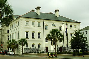
Charleston County Courthouse Charleston County Courthouse
Verwaltung
US-Bundesstaat :
South Carolina
Verwaltungssitz :
Charleston
Adresse des
County Courthouse
Gründung :
1769
Gebildet aus:
Berkeley County Colleton County
Vorwahl :
001 843
Demographie
Einwohner :
408.235 (Stand: 2020 )
Bevölkerungsdichte :
171,67 Einwohner/km2
Geographie
Fläche gesamt:
3517 km²
Wasserfläche :
1139 km²
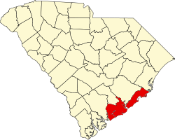
Karte
Karte von Charleston County innerhalb von South Carolina
Website : www.charlestoncounty.org
Charleston County [ 1] County im US-Bundesstaat South Carolina der Vereinigten Staaten . Das U.S. Census Bureau hat bei der Volkszählung 2020 eine Einwohnerzahl von 408.235[ 2] County Seat ) ist Charleston .
Geographie
Das County liegt im Südwesten von South Carolina, grenzt an den Atlantischen Ozean und hat eine Fläche von 3517 Quadratkilometern, wovon 1139 Quadratkilometer Wasserfläche sind. Es grenzt im Uhrzeigersinn an folgende Countys: Berkeley County , Georgetown County , Colleton County und Dorchester County .
Das County ist Teil der Metropolregion Charleston–North Charleston .
Geschichte
Charleston County wurde 1769 als Gerichtsbezirk aus Teilen des Berkeley County und des Colleton County gebildet. Am 16. April 1868 erhielt es den Status eines eigenständigen Countys. Benannt wurde es nach König Charles II. von England , der nach dem Tod von Oliver Cromwell in England wieder die Monarchie herstellte.[ 3]
Historische Objekte
Charleston
Ein paar Blocks weiter, befindet sich ebenfalls in der Meeting Street auf Nummer 51, das als historisch ausgewiesene Nathaniel Russell House [ 4] Die Drayton Hall ist eine von 43 National Historic Landmarks im County. 43 Orte im County haben den Status einer National Historic Landmark .[ 7] National Register of Historic Places (NRHP) eingetragen (Stand 27. Juli 2018).[ 8]
Bevölkerungsentwicklung
Census
Einwohner
± rel.
1790
46.017
—
1800
57.480
24,9 %
1810
63.179
9,9 %
1820
80.212
27 %
1830
86.338
7,6 %
1840
82.661
−4,3 %
1850
83.844
1,4 %
1860
70.100
−16,4 %
1870
88.863
26,8 %
1880
102.800
15,7 %
1890
59.903
−41,7 %
1900
88.006
46,9 %
1910
88.594
0,7 %
1920
108.450
22,4 %
1930
101.050
−6,8 %
1940
121.105
19,8 %
1950
164.856
36,1 %
1960
216.382
31,3 %
1970
247.650
14,5 %
1980
276.974
11,8 %
1990
295.039
6,5 %
2000
309.969
5,1 %
2010
350.209
13 %
2020
408.235
16,6 %
Zahlen nach United States Census
Orte im Charleston County
Im Charleston County liegen 16 Gemeinden, davon vier Cities Towns :[ 9]
Cities
Towns
Zu Statistikzwecken führt das U.S. Census Bureau zwei Census-designated places , die keine Selbstverwaltung besitzen.
3 teilweise im Dorchester County
4 nicht in der Quelle genannt, nur zu einem kleinen Teil im Dorchester County und Berkeley County
Siehe auch
Weblinks
Einzelnachweise
↑ Charleston County. Geographic Names Information System .United States Geological Survey , United States Department of the Interior , abgerufen am 22. Februar 2011 (englisch). ↑ Explore Census Data Total Population in Charleston County, South Carolina. Abgerufen am 19. März 2023 . ↑ Charles Curry Aiken, Joseph Nathan Kane: The American Counties: Origins of County Names, Dates of Creation, Area, and Population Data, 1950–2010 . 6. Auflage. Scarecrow Press, Lanham 2013, ISBN 978-0-8108-8762-6 , S. 51 .
↑ a b c NRIS ↑ NHL : College of Charleston Memento Internet Archive ↑ NHL: Parish House of the Circular Congregational Church Memento Internet Archive
↑ Listing of National Historic Landmarks by State: South Carolina National Park Service , abgerufen am 27. Juli 2018.↑ Suchmaske Datenbank National Park Service , abgerufen am 27. Juli 2018.↑ Municipalities. charlestoncounty.org. Abgerufen am 28. Dezember 2022 (englisch).
32.82 -79.9 Koordinaten: 32° 49′ N , 79° 54′ W


