Linea U6 (metropolitana di Vienna)

Linea U6
Logo
Logo
Un treno della linea
ReteMetropolitana di Vienna
StatoAustria (bandiera) Austria
CittàVienna
Apertura1989
Ultima estensione1996
GestoreWiener Linien
Caratteristiche
Stazioni24
Lunghezza17,5[1] km
Distanza media
tra stazioni
730 m
Tempo di percorrenza34[1] min
Trazione750 V CC
Scartamento1 435 mm
Materiale rotabileE6/C6, T/T1
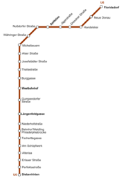
Mappa della linea
pianta
pianta

La linea U6 è una linea della metropolitana di Vienna, in Austria.

Venne aperta al pubblico il 7 ottobre 1989[1] e si estende per 17,3 km tra le stazioni di Siebenhirten e Floridsdorf: il tempo di percorrenza della linea è di 34 minuti[1]. È composta di 24 stazioni, di cui 7 sotterranee[1]. Il colore che la identifica è il marrone.

Storia

La linea U6 è la più lunga del sistema delle U-Bahn viennese. Tra Längenfeldgasse e Spittelau corre sull'originale viadotto della Stadtbahn, la ferrovia urbana, che è stata chiusa nel 1989 per essere sostituita dalla U6 che venne aperta al pubblico il 7 ottobre 1989[1]. A differenza di quanto accaduto nella U4, la maggior parte delle stazioni sono rimaste come erano in origine; per questo motivo la U6 utilizza treni e dispositivi di segnalazione ottica diversi da quelli delle altre linee. La sezione meridionale, da Siebenhirten a Bahnhof Meidling - Philadelphiabrücke, aperta il 15 aprile 1995, usa in parte un tratto in superficie costruito per i tram alla fine degli anni settanta. Il tratto successivo, da Philadelphiabrücke a Längenfeldgasse, è invece sotterraneo ed è stato aperto il 7 ottobre 1989; il tratto settentrionale tra Spittelau e Floridsdorf corre parzialmente sotto terra ed è stato aperto il 4 maggio 1996.

Stazioni

Nell'elenco che segue, a fianco ad ogni stazione, sono indicati l'anno di entrata in servizio e gli eventuali interscambi ferroviari:

La stazione di Spittelau
 Linea U6 
Unknown route-map component "uENDEa"
Urban station on track
1995 Siebenhirten
Unknown route-map component "uÜST"
Urban stop on track
1995 Perfektastraße
Urban stop on track
1995 Erlaaer Straße
Unknown route-map component "uPSLa" Unknown route-map component "uKDSTa"
Deposito Rößlergasse
Unknown route-map component "uKRWg+l" Unknown route-map component "uKRWr"
Unknown route-map component "uÜST"
Unknown route-map component "uhHSTa"
1995 Alterlaa
Unknown route-map component "uhHST"
1995 Am Schöpfwerk
Unknown route-map component "uhSTRe"
Unknown route-map component "uÜST"
Urban stop on track
1995 Tscherttegasse
Unknown route-map component "uABZgr"
binario di collegamento WLB
Unknown route-map component "utSTRa"
Unknown route-map component "utPSLa"
Unknown route-map component "utINT"
1989 Bahnhof Meidling      
Unknown route-map component "utÜST"
Urban tunnel stop on track
1989 Niederhofstraße
Unknown route-map component "utABZg+l" Unknown route-map component "utSTReq"
  da Hütteldorf
Unknown route-map component "utINT"
1989 Längenfeldgasse  
Unknown route-map component "utSTRe"
Unknown route-map component "uTUNNEL1q" Unknown route-map component "uABZgr"
  verso Heiligenstadt
Unknown route-map component "uhKRZWa"
Brücke über die Zeile (220,212 m), Fiume Wien
Unknown route-map component "uhÜST"
Unknown route-map component "uhHST"
1989 Gumpendorfer Straße
Unknown route-map component "uhtSTRa"
Unknown route-map component "uetKRWgl" Unknown route-map component "uextKRW+r"
ex tunnel della Stadtbahn fino al 1990
Unknown route-map component "utSTRq" Unknown route-map component "utTINTto" Unknown route-map component "uxtKRZto"
1989 Westbahnhof    
Unknown route-map component "utPSLe" Unused urban tunnel straight track
Unknown route-map component "uetKRWg+l" Unknown route-map component "uextKRWr"
Unknown route-map component "utÜST"
Unknown route-map component "utCSTRa"
Unknown route-map component "uCHST"
1989 Burggasse-Stadthalle
Unknown route-map component "uCSTRe"
Unknown route-map component "uhHSTa"
1989 Thaliastraße
Unknown route-map component "uhÜST"
Unknown route-map component "uhHST"
1989 Josefstädter Straße
Unknown route-map component "uhHST"
1989 Alser Straße
Unknown route-map component "uhSTRe"
Unknown route-map component "uÜST"
Unknown route-map component "uKRWgl" Unknown route-map component "uKRW+r"
Urban stop on track Urban straight track
1989 Michelbeuern-AKH
Unknown route-map component "uPSLe" Urban non-passenger station/depot on track
stazione di servizio Michelbeuern
Unknown route-map component "uABZg+l" Unknown route-map component "uABZqr"
binario di connessione a Straßenbahn
Unknown route-map component "uhSTRa"
Unknown route-map component "uhHST"
1989 Währinger Straße-Volksoper
Unknown route-map component "uhÜST"
Unknown route-map component "uhHST"
1989 Nußdorfer Straße
Unknown route-map component "uehABZgl" Unknown route-map component "uexhSTReq"
verso Heiligenstadt fino al 1996
Unknown route-map component "ueABZq+r" Unknown route-map component "uhTINT" Urban transverse track
1996 Spittelau    
Unknown route-map component "uexhSTRl" Unknown route-map component "uehABZgr"
collegamento fino al 1991
Unknown route-map component "uhKRZW"
U6-Donaukanalbrücke, Donaukanal
Unknown route-map component "uhtSTRa"
Unknown route-map component "utÜST"
Urban tunnel stop on track
1996 Jägerstraße
Unknown route-map component "utÜST"
Urban tunnel stop on track
1996 Dresdner Straße
Unknown route-map component "uhtSTRe"
Unknown route-map component "uhINT"
1996 Handelskai    
Unknown route-map component "uhKRZW"
Georg-Danzer-Steg, Danubio
Unknown route-map component "uhÜST"
Unknown route-map component "uhKRZW"
Danubio Nuovo
Unknown route-map component "uhHST"
1996 Neue Donau
Unknown route-map component "uhtSTRa"
Unknown route-map component "utÜST"
Urban tunnel station on track
1996 Floridsdorf   
Unknown route-map component "utENDEe"
Manuale · Legenda · Convenzioni di stile

Note

Voci correlate

Altri progetti

Collegamenti esterni

Controllo di autoritàVIAF (EN248668009 · GND (DE4289779-8