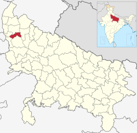
District de Hapur

District de Hapur
बुलन्दशहर ज़िला
Administration
Pays Drapeau de l'Inde Inde
État Uttar Pradesh
Chef-lieu Hapur
Fuseau horaire IST (UTC+5:30)
Géographie
Coordonnées 28° 43′ 51″ nord, 77° 46′ 33″ est
Superficie 66 000 ha = 660 km2
Localisation
Localisation de District de Hapurबुलन्दशहर ज़िला
Géolocalisation sur la carte : Inde
Voir sur la carte administrative d'Inde
District de Hapur बुलन्दशहर ज़िला
Liens
Site web http://hapur.nic.in/

Le district de Hapur auparavant Panchsheel Nagar est une division administrative de la division de Meerut dans l'État de l'Uttar Pradesh, en Inde[1],[2].

Géographie

Le centre administratif du district est Hapur.

Histoire

Liens externes

Articles connexes

Références

  1. (en) UP gets three new districts: Prabuddhanagar, Panchsheel Nagar, Bhimnagar, The Indian Express, (lire en ligne)
  2. (en) « Important Cabinet Decisions », Lucknow, Information and Public Relations Department (consulté le )