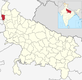
District de Baghpat

District de Baghpat
बाग़पत ज़िला
Administration
Pays Drapeau de l'Inde Inde
État Uttar Pradesh
Chef-lieu Baghpat
Fuseau horaire IST (UTC+5:30)
Démographie
Population 1 303 048 hab. (2011[1])
Densité 986 hab./km2
Géographie
Coordonnées 28° 56′ nord, 77° 13′ est
Superficie 132 100 ha = 1 321 km2
Localisation
Localisation de District de Baghpatबाग़पत ज़िला
Géolocalisation sur la carte : Inde
Voir sur la carte administrative d'Inde
District de Baghpat बाग़पत ज़िला
Liens
Site web http://baghpat.nic.in/

Le district de Baghpat (en hindi : बाग़पत ज़िला, en ourdou : باغپت ضلع) est une division administrative de la division de Meerut dans l'État de l'Uttar Pradesh, en Inde.


Géographie

Le centre administratif du district est Baghpat. La superficie du district est de 1 321 km2[1] et la population était en 2011 de 1 303 048 habitants[1].

Le taux d'alphabétisation est de 65,65 %[2].

Histoire

Sites et monuments

Liens externes

Liens internes

Références

  1. a b et c (en) « Districts of Uttar Pradesh », Recensement 2011, Gouvernement de l'Inde (consulté le )
  2. (en) « District-specific Literates and Literacy Rates, 2001 », Registrar General, India, Ministry of Home Affairs (consulté le )