Villeneuve, Alpes-de-Haute-Provence

Villeneuve
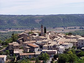
The church and surrounding buildings in Villeneuve
Coat of arms of Villeneuve
Location of Villeneuve
Map
Villeneuve is located in France
Villeneuve
Villeneuve
Villeneuve is located in Provence-Alpes-Côte d'Azur
Villeneuve
Villeneuve
Coordinates: 43°53′42″N 5°51′49″E / 43.895°N 5.8636°E / 43.895; 5.8636
CountryFrance
RegionProvence-Alpes-Côte d'Azur
DepartmentAlpes-de-Haute-Provence
ArrondissementForcalquier
CantonOraison
IntercommunalityDurance-Luberon-Verdon Agglomération
Government
 • Mayor (2020–2026) Serge Faudrin[1]
Area
1
25.55 km2 (9.86 sq mi)
Population
 (2022)[2]
4,386
 • Density170/km2 (440/sq mi)
Time zoneUTC+01:00 (CET)
 • Summer (DST)UTC+02:00 (CEST)
INSEE/Postal code
04242 /04180
Elevation313–600 m (1,027–1,969 ft)
(avg. 450 m or 1,480 ft)
1 French Land Register data, which excludes lakes, ponds, glaciers > 1 km2 (0.386 sq mi or 247 acres) and river estuaries.

Villeneuve (French pronunciation: [vilnœv] ; Provençal: Vilanòva) is a commune in the Alpes-de-Haute-Provence department in southeastern France.

Villeneuve is located in Durance valley. This village, like many other villages in Provence, is built on the top of a hill to keep it protected from invaders. Villeneuve in French mean "New town" but was constructed in Middle Ages, originally further in the forest on the top of a high cliff. Only the little chapel remains on the rock to show where the original village was located.

Population

Historical population
YearPop.±% p.a.
1793 647—    
1800 720+1.54%
1806 696−0.56%
1821 806+0.98%
1831 872+0.79%
1836 846−0.60%
1841 776−1.71%
1846 783+0.18%
1851 793+0.25%
1856 778−0.38%
1861 785+0.18%
1866 731−1.42%
1872 798+1.47%
1876 745−1.70%
1881 681−1.78%
1886 600−2.50%
1891 576−0.81%
1896 577+0.03%
YearPop.±% p.a.
1901 566−0.38%
1906 1,143+15.09%
1911 605−11.95%
1921 591−0.23%
1926 537−1.90%
1931 496−1.58%
1936 575+3.00%
1946 586+0.19%
1954 575−0.24%
1962 639+1.33%
1968 861+5.10%
1975 1,144+4.14%
1982 1,730+6.09%
1990 2,516+4.79%
1999 2,964+1.84%
2007 3,448+1.91%
2012 3,713+1.49%
2017 4,196+2.48%
Source: EHESS[3] and INSEE (1968-2017)[4]

See also

References

  1. ^ "Répertoire national des élus: les maires". data.gouv.fr, Plateforme ouverte des données publiques françaises (in French). 2 December 2020.
  2. ^ "Populations de référence 2022" (in French). The National Institute of Statistics and Economic Studies. 19 December 2024.
  3. ^ Des villages de Cassini aux communes d'aujourd'hui: Commune data sheet Villeneuve, EHESS (in French).
  4. ^ Population en historique depuis 1968, INSEE