Mount Beppo, Queensland

Mount Beppo
Somerset RegionQueensland
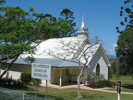
Apostolic Church, Mount Beppo, 2005
Mount Beppo is located in Queensland
Mount Beppo
Mount Beppo
Coordinates27°07′24″S 152°26′04″E / 27.1233°S 152.4344°E / -27.1233; 152.4344 (Mount Beppo (centre of locality))
Population251 (2021 census)[1]
 • Density5.081/km2 (13.16/sq mi)
Establishedearly 1880s
Postcode(s)4313
Area49.4 km2 (19.1 sq mi)
Time zoneAEST (UTC+10:00)
Location
LGA(s)Somerset Region
State electorate(s)Nanango
Federal division(s)Blair
Suburbs around Mount Beppo:
Toogoolawah Cressbrook Cressbrook
Toogoolawah Mount Beppo Cooeeimbardi
Ottaba Coal Creek Caboonbah

Mount Beppo is a rural locality in the Somerset Region, Queensland, Australia.[2] In the 2021 census, Mount Beppo had a population of 251 people.[1]

Geography

The Brisbane River forms the north-eastern boundary.[3]

The Brisbane Valley Highway passes to the west.

History

Mount Beppo State School (now closed)

The district takes its name from the neighbouring mountain, whose name in turn is believed to be derived from the Yuggera word bippo meaning mountain. However, as Yuggera is not a local indigenous language, it may have been Europeans who introduced the name.[2]

The district was first settled in the early 1880s; the Granzein and Soden families were among the early pioneers.[4]

Mount Beppo State School opened on 4 September 1893. The chairman of the school was Henry Plantagenet Somerset. In 1929 the school had about 80 pupils. The school closed on 31 December 1972.[5][6] It was at 13 German Reserve Road (27°07′56″S 152°27′14″E / 27.1321°S 152.4538°E / -27.1321; 152.4538 (Mount Beppo State School (former))).[7][8][9]

By 1929, there were two churches at Mount Beppo, the Lutheran church and the Apostolic church, both with associated cemeteries.[6]

The Lutheran Church was opened on 12 August 1888.[10] It was extended and re-dedicated in 1930.[11]

The first Apostolic Church services were held in 1883 in the home of Mr Carl Casper Meier and the church building was constructed about 1889, but in 1911 the building was relocated higher up the hill and extended. Further extensions occurred at part of the golden jubilee celebrations in 1934.[12][13] In 2014, only the Apostolic Church remains, but both cemeteries still exist.

The district was known for its brass band, which was established in 1898 and celebrated its golden jubilee in 1949.[6][14][15]

Caboonbah Undenominational Church, 2005

Caboonbah Undenominational Church is a union church. It was established by Henry Plantagenet Somerset and takes its name, "Caboonbah", from the Somerset family homestead, Caboonbah Homestead, nearby. The wooden structure was designed by Somerset's wife Katherine Rose Somerset, the daughter of David Cannon McConnell and Mary McConnel (nee McLeod) who founded the Cressbrook Homestead. The church was built by Lars Andersen. It opened in 1905 to serve the local farming community. It is located on Cressbrook-Caboonbah Road (27°08′03″S 152°28′02″E / 27.13412°S 152.46732°E / -27.13412; 152.46732 (Caboonbah Undenominational Church)).[16]

Mount Beppo public hall

A public hall was opened at Mount Beppo on 15 March 1930 by Henry Plantagenet Somerset, former Member of the Legislative Assembly for the district, with the then current Member, Ernest Grimstone, in attendance.[17]

Demographics

In the 2011 census, the population of Mount Beppo was 347 people.[18]

In the 2016 census, Mount Beppo had a population of 216 people.[19]

In the 2021 census, Mount Beppo had a population of 251 people.[1]

Education

There are no schools in Mount Beppo. The nearest primary school is Toogoolawah State School in neighbouring Toogoolawah to the north-west. The nearest secondary school is Toogoolawah State High School also in Toogoolawah.[9]

References

  1. ^ a b c Australian Bureau of Statistics (28 June 2022). "Mount Beppo (SAL)". 2021 Census QuickStats. Retrieved 28 February 2023. Edit this at Wikidata
  2. ^ a b "Mount Beppo – locality in Somerset Region (entry 44899)". Queensland Place Names. Queensland Government. Retrieved 29 December 2020.
  3. ^ "Mount Beppo, Queensland" (Map). Google Maps. Retrieved 15 September 2021.
  4. ^ "Rich Surrounding District". The Queensland Times. National Library of Australia. 18 June 1929. p. 5 Edition: Daily. Retrieved 14 April 2014.
  5. ^ "Agency ID 6513, Mount Beppo State School". Queensland State Archives. Retrieved 14 April 2014.
  6. ^ a b c "Mt. Beppo". The Brisbane Courier. National Library of Australia. 30 March 1929. p. 11. Retrieved 14 April 2014.
  7. ^ "Cressbrook" (Map). Queensland Government. 1944. Retrieved 11 April 2022.
  8. ^ "Queensland Two Mile series sheet 2m77" (Map). Queensland Government. 1955. Retrieved 11 April 2022.
  9. ^ a b "Queensland Globe". State of Queensland. Retrieved 3 March 2021.
  10. ^ "Public Announcements". Queensland Times, Ipswich Herald & General Advertiser. National Library of Australia. 9 August 1888. p. 2. Archived from the original on 3 March 2021. Retrieved 14 April 2014.
  11. ^ "Mt. Beppo Lutherans". The Queensland Times. National Library of Australia. 19 September 1930. p. 4 Edition: Daily. Archived from the original on 3 March 2021. Retrieved 14 April 2014.
  12. ^ "Fine Community Sprit". The Queensland Times. National Library of Australia. 12 November 1934. p. 8 Edition: Daily. Retrieved 14 April 2014.
  13. ^ "History of the Church". The Queensland Times. National Library of Australia. 12 November 1934. p. 8 Edition: Daily. Archived from the original on 3 March 2021. Retrieved 14 April 2014.
  14. ^ "Gillmeister—Teske". Queensland Times, Ipswich Herald & General Advertiser. National Library of Australia. 26 September 1899. p. 7. Archived from the original on 3 March 2021. Retrieved 14 April 2014.
  15. ^ "Mt. Beppo Brass Band Jubilee Celebrated". The Queensland Times. National Library of Australia. 16 September 1948. p. 5 Edition: Daily. Archived from the original on 3 March 2021. Retrieved 14 April 2014.
  16. ^ "Caboonbah Undenominational Church". Brisbane Valley Historical Society. Archived from the original on 15 June 2005. Retrieved 6 September 2022.
  17. ^ "Mt. Beppo Hall". The Queensland Times. National Library of Australia. 22 March 1930. p. 7 Edition: Daily. Archived from the original on 3 March 2021. Retrieved 14 April 2014.
  18. ^ Australian Bureau of Statistics (31 October 2012). "Mount Beppo". 2011 Census QuickStats. Retrieved 11 April 2014. Edit this at Wikidata
  19. ^ Australian Bureau of Statistics (27 June 2017). "Mount Beppo (SSC)". 2016 Census QuickStats. Retrieved 20 October 2018. Edit this at Wikidata

Further reading

  • Toogoolawah State School 75th Anniversary, 1905-1980, and the former schools of the Toogoolawah district 1874-1972. Toogoolawah State School. 1980. — also includes Mount Beppo State School, Ivorys Creek Provisional School, Cross Roads Provisional School, Ottaba Provisional School, Murrumba State School, Mount Esk Pocket School, Kipper Provisional School, Lower Cressbrook School, Fulham School, Sandy Gully State School, Cooeeimbardi State School, Scrub Creek State School