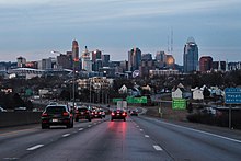
Interstate 71

Interstate 71 marker

Interstate 71

Map
I-71 highlighted in red
Route information
Maintained by KYTC and ODOT
Length345.57 mi[1] (556.14 km)
NHSEntire route
RestrictionsNo hazmats or explosives allowed in the Lytle Tunnel, on the Brent Spence Bridge, or (for thru traffic only) inside the Columbus Outerbelt
Major junctions
South end I-64 / I-65 in Louisville, KY
Major intersections
North end I-90 / I-490 in Cleveland, OH
Location
CountryUnited States
StatesKentucky, Ohio
CountiesKY: Jefferson, Oldham, Henry, Trimble, Carroll, Gallatin, Boone, Kenton
OH: Hamilton, Warren, Clinton, Greene, Fayette, Madison, Pickaway, Franklin, Delaware, Morrow, Richland, Ashland, Wayne, Medina, Cuyahoga
Highway system
  • Kentucky State Highway System
  • Ohio State Highway System
KY 70KY KY 72
SR 70OH SR 71

Interstate 71 (I-71) is a north–south Interstate Highway in the midwestern and southeastern regions of the United States. Its southern terminus is at an interchange with I-64 and I-65 (the Kennedy Interchange) in Louisville, Kentucky, and its northern terminus at an interchange with I-90 in Cleveland, Ohio. I-71 runs concurrently with I-75 from a point about 20 miles (32 km) south of Cincinnati, Ohio, into Downtown Cincinnati. While most odd numbered Interstates run north–south, I-71 takes more of a northeast–southwest course, with some east–west sections, and is mainly a regional route serving Kentucky and Ohio. It links I-80 and I-90 to I-70 and ultimately (via I-65) links to I-40. Major metropolitan areas served by I-71 include Louisville, Cincinnati, Columbus, and Cleveland.

Approximately three-quarters of the route lie east of I-75, leaving I-71 out of place in the Interstate grid.

Route description

Lengths
  mi[1] km
KY 97.42 156.78
OH 248.15 399.36
Total 345.57 556.14

Kentucky

Southern end of I-71 in Downtown Louisville, Kentucky
I-71 in Carroll County, Kentucky
I-71 (and I-75) heading northbound into Cincinnati, Ohio, from Kentucky

In Kentucky, I-71 begins east of Downtown Louisville at the Kennedy Interchange, where it meets I-64 and I-65. This interchange is sometimes called the "Spaghetti Junction". From Louisville, it roughly follows the Ohio River in a diagonal path toward Northern Kentucky. Between Louisville and Cincinnati, I-71 is largely a four-lane highway, except for the approach to Kentucky Speedway in Sparta in which it runs three lanes each way for about two miles (3.2 km).

Near the town of Carrollton, there are signs marking the location of a tragic accident that occurred on May 14, 1988, when a drunk driver was driving north in the southbound lanes and struck a church bus full of children and teenagers, causing the bus's fuel tank to ignite into flames and killing 27 people on board. It is one of the worst bus accidents in state and national history.

After having run 77 miles (124 km) from Louisville, I-71 merges with I-75 near Walton after which it intersects I-275, the Cincinnati beltway. After passing through Covington, the freeway crosses the Ohio River via the lower level of the Brent Spence Bridge (while the southbound direction uses the upper level) and continues into Cincinnati.

Ohio

Heading northbound into Columbus, Ohio
Northern terminus at I-90 in Downtown Cleveland, Ohio

In Cincinnati, it splits immediately from I-75 and heads due east onto Fort Washington Way, where it continues through Downtown Cincinnati concurrently with U.S. Route 50 (US 50) for less than one mile (1.6 km). Just east of downtown, US 50 splits from I-71 and continues east; I-71 bends north and receives I-471, a spur from southeast of the city. I-71 then heads in a general northeast direction through the Lytle Tunnel and urban Cincinnati and into its surrounding suburbs. After another interchange with the I-275 beltway, the freeway leaves the metropolitan area and heads toward Columbus. It continues northeast until it reaches South Lebanon, where it begins cutting east across the flat plains of southwest Ohio. The freeway crosses the Little Miami River on the Jeremiah Morrow Bridge, which is a continuous truss bridge and the tallest bridge in Ohio, at 239 feet (73 m) above the river. I-71 heads toward Columbus then intersects with the bypass I-270 before heading north into urban Columbus, where it junctions I-70. About a mile (1.6 km) north of the I-70 junction, it intersects with I-670. After another interchange with the I-270 bypass, the highway exits Columbus and continues north until near Delaware, where it again turns northeast. Beginning its path to Cleveland, I-71 enters the rolling farm country on the edges of the Allegheny Plateau. It continues in this fashion to LodiWestfield Center and its junction with I-76, which provides access to Akron and points east. Heading north to Medina, it meets the terminus of I-271. The highway then continues north into urban Cuyahoga County and Cleveland's suburbs, intersecting the Ohio Turnpike/I-80. Passing Cleveland Hopkins International Airport, I-71 meets I-480 and enters Cleveland's west side, continuing on to downtown. It junctions with State Route 176 (SR 176) and terminates at I-90 on the Innerbelt.

History

I-71 in Kentucky marker
I-71 in Ohio marker
1957 versions of the Interstate Highway marker for Kentucky and Ohio

Kentucky

The first section of I-71 in Louisville opened in December 1966 between its terminus at Spaghetti Junction and Zorn Avenue, its first exit. Its junction with I-264 opened in July 1968, and the complete Kentucky portion of the Interstate was opened to the public in July 1969. At that point, it replaced US 42 as the primary link between Cincinnati and Louisville.[2]

Ohio

Much of I-71 in Ohio was intended to be SR 1. SR 1 was originally planned in the 1950s as a second Ohio Turnpike extending southwest to northeast across the state. It was planned to run from Cincinnati to Conneaut and connect with an extension built across the panhandle of Pennsylvania to the New York State Thruway. As the highway was being planned, the Federal-Aid Highway Act of 1956 was enacted, and the project was converted from a toll road to a freeway. It was designated as SR 1, since the Interstate Highway numbering system had not yet been implemented. Portions of the freeway began to be completed and opened in 1959 with the new Interstate Highway funding, and they were marked as SR 1 as well as with their new Interstate Highway number. Since large gaps existed along the corridor where no freeway had yet been completed, existing two-lane or four-lane highways were also designated as SR 1 in order to complete the route. The SR 1 signage was removed in 1966 as the Interstate Highway numbers adequately marked the route by then and the state highway numbering was superfluous.

Columbus-area highway marker designating I-71 and SR 1 (1965)

In Columbus, the portion of I-71 that bounds Worthington's eastern edge was originally called the North Freeway. Costing $13.8 million (equivalent to $106 million in 2023[3]), it was constructed south from SR 161, arriving at 11th Avenue by August 1961. It took another year to construct the portion between 11th and 5th avenues, mainly due to the need to construct a massive underpass under the Pennsylvania Railroad's Grogan Yard. Today, only two tracks cross the viaduct, and the rest of the structure supports a large, weedy field. By August 1962, the freeway had reached Fifth Avenue, and it reached downtown in November 1962.

I-71 was originally planned to follow the Innerbelt Freeway northward from its current northern terminus to the Cleveland Memorial Shoreway at Dead Man's Curve when I-90 was planned to continue westward from there along the Shoreway.[4]

Upon its completion, I-71 replaced SR 3 as the primary highway link between Cincinnati, Columbus, and Cleveland.

Between 2004 and 2006, the interchange at milepost 121 in the far northern reaches of Columbus was reconstructed to allow access to the eastern extension of Gemini Place.[5] Before that, it was a simple diamond interchange with SR 750 (Polaris Parkway).

Rebuilding and widening program

In 1999, the state of Ohio began a 10-year, $500-million (equivalent to $860 million in 2023[3]) project to improve I-71 between Columbus and Cleveland. The plans did not include widening the 25-mile (40 km) stretch in Delaware and Morrow counties, calling for patching that section instead. At that time, state transportation officials said they did not plan to widen that section for two reasons: traffic studies did not support the widening and there was no money for the project.[6] But Ohio Department of Transportation (ODOT) officials eventually gave in under pressure from elected officials and business owners to widen the remaining 25-mile (40 km) stretch of I-71 from just north of the US 36/SR 37 interchange in Delaware County to the Morrow–Richland county line.[7] The reconstruction and widening on the last 25-mile (40 km) stretch of I-71 in Delaware and Morrow counties began in early 2012, and the work was completed in mid-2015 at a cost of $144 million (equivalent to $181 million in 2023[3]).[7]

Exit list

StateCountyLocationmi[8][9]kmExitDestinationsNotes
KentuckyJeffersonLouisville0.0000.000
I-65 south – Nashville
Southern terminus; I-65 exit 137
136CJefferson Street – DowntownSouthbound exit and northbound entrance; exit number follows I-65
1

I-65 north (Toll Bridge) / I-64 west – Indianapolis, St. Louis
Signed as exits 1A (I-64) and 1B (I-65) southbound; no exit numbers northbound; I-64 exit 6; I-65 exit 137

I-64 east – Lexington
Northbound exit and southbound entrance; I-64 exit 5A
1.7242.7752Zorn Avenue
4.9667.9925 I-264 (Watterson Expressway)I-264 exit 23
9.06314.5859
I-265 / KY 841 (Gene Snyder Freeway) to US 42
Signed as exits 9A (south) and 9B (north); I-265 exit 35
Oldham14.48823.31614 KY 329 – Crestwood, Pewee Valley
17.47828.12817 KY 146 – Buckner, Crestwood, Pewee Valley
18.50729.78418 KY 393 – Buckner
La Grange20.633.221 KY 2857 – La GrangeUnder construction; planned completion in 2024.[10][11]
21.86935.19522 KY 53 – La Grange, Ballardsville
HenryPendleton27.84044.80428
KY 153 to KY 146 – Sligo, New Castle
Campbellsburg33.50553.92134 US 421 – Campbellsburg, New Castle, Bedford
Trimble
No major junctions
Carroll42.80268.88343
KY 389 to KY 55 – Prestonville, English
44.31271.31344 KY 227 – Worthville, Carrollton
Gallatin54.98088.48255
KY 1039 to KY 465 – Vevay
Serves Kentucky Speedway
56.67391.20657 KY 35 – Sparta, Warsaw
Glencoe61.77499.41662 US 127 – Glencoe, Owenton
Boone72.195116.18772 KY 14 – Verona
77.724125.08577
I-75 south – Lexington
Southern end of I-75 overlap; exit numbers switch to follow I-75's mileposts, I-75 exit 173
79.556128.033175 KY 338 – Richwood
Florence82.275132.409178 KY 536 (Mt. Zion Road)
84.298135.664180 US 42 / US 127 – Union, Florence
84.694136.302180AMall RoadSouthbound exit and northbound entrance; serves Florence Mall; former KY 3157
85.449137.517181 KY 18 – Florence, Burlington
86.652139.453182 KY 1017 (Turfway Road)
KentonErlanger87.967141.569184 KY 236 – ErlangerSigned as exits 184A (east) and 184B (west) southbound
88.900143.071185
I-275 to I-471 – Cincinnati/Northern Kentucky International Airport
I-275 exit 84
Fort Mitchell90.539145.708186 KY 371 (Buttermilk Pike)
91.913147.920188 US 25 / US 42 / US 127 (Dixie Highway) – Fort Mitchell
Fort Wright92.870149.460189 KY 1072 (Kyles Lane) – Fort Wright, Park Hills
Covington94.707–
94.858
152.416–
152.659
19112th Street (KY 1120), Pike Street (US 25 / US 42 / US 127) – Covington
95.414–
95.507
153.554–
153.704
1925th Street (KY 8) – Covington, Newport
Ohio River97.42
0.00
156.78
0.00
Brent Spence Bridge
KentuckyOhio line
OhioHamiltonCincinnati0.22–
0.50
0.35–
0.80


I-75 north / US 50 west – Dayton
Northern end of I-75 overlap; southern end of US 50 overlap
1BSecond Street – Downtown, RiverfrontExit unnumbered until 2018
1.111.79


US 50 east (Columbia Parkway) to I-471 / US 52
Northern end of US 50 overlap; northbound exit and southbound entrance
Lytle Tunnel
Sharp turn (40 mph or 64 km/h) in both directions
1.993.201A
I-471 south – Newport
Southbound exit and northbound entrance; exit unnumbered until 2018
2.33–
2.48
3.75–
3.99
2 US 42 (Reading Road) / Eden Park Drive / Gilbert Avenue (US 22 / SR 3) / Eighth Street – Ballpark, Stadium/ArenaSplit into exit  2A (US 42) and 2B (Gilbert/8th) southbound; Gilbert Ave./8th St. not signed northbound, Eden Park Dr. not signed southbound
3.33–
4.3
5.36–
6.9
McMillan StreetNorthbound entrance only
3AWilliam Howard Taft RoadSouthbound exit only
3B Martin Luther King Drive – Level I Trauma CenterSigned as exit 3 northbound
4.46–
6.03
7.18–
9.70
5Dana Avenue / Montgomery Road (US 22 / SR 3)
Norwood6.75–
6.96
10.86–
11.20
6 SR 561 (Smith Road / Edwards Road)
Cincinnati8.0412.948ARidge Avenue southNorthbound exit and southbound entrance
8B SR 562 – NorwoodSigned as exit 7 southbound
Columbia Township8.5113.708CRidge Avenue northNorthbound exit and southbound entrance
8.7514.088Kennedy Avenue, Ridge AvenueSouthbound exit and northbound entrance
9.91–
9.92
15.95–
15.96
9Red Bank Road – Fairfax
Silverton10.6817.1910Stewart RoadNorthbound exit and southbound entrance
Sycamore Township11.8119.0111Kenwood RoadNorthbound exit and southbound entrance
12.4420.0212 US 22 / SR 3 (Montgomery Road)
Montgomery14.1322.7414 SR 126 (Ronald Reagan Cross County Highway)
15.8025.4315Pfeiffer Road
17.51–
17.54
28.18–
28.23
17

I-275 to SR 32 / I-75
I-275 exit 49; signed as exits 17A (east) & 17B (west) southbound
HamiltonWarren
county line
SymmesDeerfield
township line
19.88–
19.97
31.99–
32.14
19Mason Montgomery Road / Fields Ertel Road
WarrenMason23.5337.8724Western Row Road / Kings Island Drive / Innovation Way – Kings IslandSigned as Western Row Road and Kings Island Drive northbound and Western Row Road and Innovation Way southbound; originally constructed as northbound exit and southbound entrance only but expanded to a full interchange in 2019[12]
25.3040.7225
SR 741 north (Kings Mills Road) – Mason, Kings Mills, Kings Island
LebanonSouth Lebanon
city line
28.3345.5928 SR 48 – South Lebanon, Lebanon
Turtlecreek Township32.5652.4032 SR 123 – Morrow, Lebanon
Washington Township36.7459.1336Wilmington Road
ClintonChester Township45.1172.6045 SR 73 – Waynesville, Wilmington
Liberty Township50.74–
50.75
81.66–
81.67
50 US 68 – Xenia, Wilmington
GreeneJefferson Township58.0193.3658 SR 72 – Sabina, Jamestown
FayetteOcta65.33105.1465 US 35 (SR 435) – Xenia, Washington Court House
Jeffersonville69.49111.8369 SR 41 / SR 734 – South Solon, Jeffersonville, Washington Court House
Paint Township75.03120.7575 SR 38 – Bloomingburg, Midway
MadisonPleasant Township84.27135.6284 SR 56 – Mount Sterling, London
Pickaway
No major junctions
FranklinPleasant Township94.15151.5294 US 62 / SR 3 – Grove City, Orient, Harrisburg
Jackson Township97.16156.3697 SR 665 (London-Groveport Road)Interchange fully opened August 17, 2012[13]
Grove City98.85159.0899Hoover Road – Grove CityProposed
100.60161.90100Stringtown Road – Grove City
Jackson Township101.68163.64101 I-270 – Dayton, WheelingSigned northbound as exit 100, southbound as exit 101; I-270 exit 55
Columbus103.86167.15104 SR 104 / Frank Road
105.43169.67105Greenlawn Avenue
106.33171.12106A
I-70 west – Dayton
Northbound exit and southbound entrance; I-70 exit 99A
106B
SR 315 north – Worthington
No exit number southbound; I-70 exit 99B

I-70 west – Dayton
Southern end of I-70 overlap; southbound exit and northbound entrance; I-70 exit 99A; exit numbers switch to follow I-70's mileposts
US 23 (Third Street / Fourth Street) / Fulton StreetNew interchange to replace exits 100A-B; to have no southbound exit
107.07–
107.17
172.31–
172.47
100A
US 23 south (High Street) / Front Street
No northbound entrance; southbound exit is via exit 100B
107.41172.86100B
US 23 north (Fourth Street) / Livingston Avenue (US 33)
107.90–
108.10
173.65–
173.97
101BParsons AvenueNorthbound exit only
107
I-70 east
Northern end of I-70 overlap; I-70 exit 101A ; left exit southbound
108.20174.13108AMain StreetNo northbound exit
108.63174.82108B US 40 (Broad Street)Southbound entrance and northbound exit
109.16175.68109A I-670 – Airport, DaytonNorthbound exit and southbound entrance; I-670 exit 5; northbound off-ramp to I-670 east includes direct ramp onto Leonard Avenue
108.93175.31109BSpring Street – DowntownSouthbound exit and northbound entrance
109.61176.40109A I-670 – Airport, DaytonSouthbound exit and northbound entrance; I-670 exit 5
110.16177.29110AFifth AvenueNo northbound exit
110.68178.12110B 11th AvenueAccess to Linden Primary Care Center
111.15178.8811117th AvenueAccess to the Ohio State Fairgrounds & Expo Center and Ohio History Center
112.33180.78112Hudson Street
112.98181.82113Weber Road
113.46182.60114North BroadwayAccess to Riverside Methodist Hospital
114.53184.32115Cooke Road (Indianola Avenue)
115.58186.01116Morse Road / Sinclair Road
117.53189.15117 SR 161 (Dublin-Granville Road)
119.21–
119.23
191.85–
191.88
119 I-270 – Dayton, WheelingSigned as exits 119A (east) and 119B (west) southbound; I-270 exit 26
FranklinDelaware
county line
121.45–
121.92
195.45–
196.21
121
SR 750 west (Polaris Parkway) / Gemini Place / Ikea Way
Eastern terminus of SR 750; access to Polaris Shopping Center
DelawareOrange Township124200Big Walnut RoadFuture interchange[14][15]
Berkshire Township129Sunbury ParkwayFuture interchange[15]
130.64210.24131 US 36 / SR 37 – Delaware, Sunbury
MorrowBennington Township140.15225.55140 SR 61 – Sunbury, Mount Gilead, Galion
ChesterFranklin
township line
151.09243.16151 SR 95 – Fredericktown, Mount Gilead
RichlandWashington TownshipBellville
village line
165.25265.94165 SR 97 – Lexington, Bellville
Washington TownshipMansfield
city line
168.81271.67169 SR 13 – Mansfield, Bellville
Madison Township172.97278.37173 SR 39 – Mansfield, Lucas
Mifflin Township176.91284.71176 US 30 – Mansfield, WoosterIndirect southbound access to eastbound US 30 and from westbound US 30 to northbound I-71 via Crider and Koogle roads
AshlandMontgomery Township186.71300.48186 US 250 – Ashland, Wooster
WayneCongress Township196.31315.93196 SR 301 – West SalemNorthbound exit and southbound entrance
197.92318.52198 SR 539 – West Salem, Congress
MedinaHarrisville Township203.89328.13204 SR 83 – Lodi, Wooster
Westfield Township209.51337.17209 I-76 / US 224 – Lodi, AkronSigned as exits 209A (I-76/US 224 east) and 209B (US 224 west); western terminus of I-76 (Ohio), exit 1
Medina Township218.86352.22218 SR 18 – Akron, Medina
220.71355.20220
I-271 north – Erie
Northbound exit and southbound entrance
222.91358.74222 SR 3 – Hinckley, Medina
Brunswick226.03363.76226 SR 303 – Brunswick, Hinckley
CuyahogaStrongsville231.26372.18231 SR 82 (Royalton Road) – Strongsville, North RoyaltonSigned as exits 231A (east) and 231B (west) southbound
233.06375.07233 I-80 / Ohio Turnpike – Toledo, YoungstownI-80/Ohio Turnpike exit 161
Middleburg Heights234.21376.92234 US 42 – Strongsville, Parma Heights
235.37378.79235Bagley Road – Berea, Middleburg Heights
Brook Park237.53382.27237 Snow Road / Engle Road – AirportSigned as exits 237A (east) and 237B (west, Engle) southbound
Brook ParkCleveland line238.77384.26238 I-480 – Airport, Toledo, YoungstownNorthbound exit and southbound entrance; I-480 exit 11
Cleveland239.26385.05239
SR 237 south – Airport, Berea
Southbound left exit and northbound left entrance
240.57387.16240W. 150th Street
241.85389.22242AW. 130th StreetSigned as exit 242 southbound
ClevelandLinndale line242.41390.12242BBellaire RoadNorthbound exit and southbound entrance
Cleveland244.5393.5244Denison Avenue / W. 65th StreetNorthbound exit and southbound entrance
245.48–
246.20
395.06–
396.22
245 US 42 (SR 3 / Pearl Road / W. 25th Street) / Fulton Road
246.6396.9246
SR 176 south – Parma
Southbound exit and northbound entrance
246.98–
247.56
397.48–
398.41
247

I-90 west / I-490 east / W. 14th Street / Clark Avenue / Steelyard Drive
Northbound exit and southbound entrance; I-90 exit 170B; I-490 exit 1A
247.81–
248.15
398.81–
399.36

I-90 east – Downtown Cleveland
Northern terminus; I-90 exit 170B
1.000 mi = 1.609 km; 1.000 km = 0.621 mi

Auxiliary routes

I-71 has two auxiliary routes in Greater Cleveland and the Cincinnati metropolitan area. I-471 links Downtown Cincinnati with I-275. I-271 provides access to Cleveland's eastern suburbs and enables travelers on I-71 to access I-90 east without going through Cleveland proper.

See also

References

  1. ^ a b Starks, Edward (January 27, 2022). "Table 1: Main Routes of the Dwight D. Eisenhower National System of Interstate and Defense Highways". FHWA Route Log and Finder List. Federal Highway Administration. Archived from the original on September 20, 2023. Retrieved January 9, 2024.
  2. ^ Kleber, John E., ed. (2001). "Interstates and Expressways". Encyclopedia of Louisville. Lexington: University Press of Kentucky. pp. 417–418. ISBN 0813128900. Archived from the original on January 28, 2024. Retrieved October 18, 2020.
  3. ^ a b c Johnston, Louis; Williamson, Samuel H. (2023). "What Was the U.S. GDP Then?". MeasuringWorth. Retrieved November 30, 2023. United States Gross Domestic Product deflator figures follow the MeasuringWorth series.
  4. ^ Ohio Department of Highways. 1957–1958 Biennial Report (Excerpt). Ohio Department of Highways. Archived from the original on September 24, 2015. Retrieved February 27, 2013 – via Roadfan.com.
  5. ^ urbanohio.com. "Ohio Fuses Two Interchanges in Columbus". Archived from the original on June 15, 2015. Retrieved June 14, 2015.[self-published source]
  6. ^ Ferenchik, Mark (February 26, 2013). "3rd lane coming to I-71 by 2015". The Columbus Dispatch. Archived from the original on October 7, 2014. Retrieved October 4, 2014.
  7. ^ a b Hill, Todd (October 13, 2014). "I-71 widening almost finished". Mansfield News Journal. Archived from the original on June 20, 2015. Retrieved June 19, 2015.
  8. ^ "HIS Expanded Milepoint Route Log Extract". Kentucky Transportation Cabinet. October 31, 2007. Archived from the original on November 9, 2007. Retrieved April 15, 2022.
  9. ^ Office of Technical Services (January 1, 2007). "Straight Line Diagrams". Ohio Department of Transportation. Archived from the original on February 19, 2003. Retrieved April 15, 2022.
  10. ^ "Oldham County: I-71 New Interchange at Milepoint 20.6 – Project 05-483.30". Kentucky Transportation Cabinet. Archived from the original on March 25, 2023. Retrieved March 25, 2023.
  11. ^ Godbey, Dalton (October 3, 2022). "Construction on new I-71 interchange in Oldham County expected next week". Louisville, KY: WDRB. Archived from the original on March 25, 2023. Retrieved March 25, 2023.
  12. ^ Smith, Lisa (February 1, 2019). "Will it soon be easy to get off (and then back on) I-71 at Western Row?". WCPO-TV. Archived from the original on January 28, 2024. Retrieved February 3, 2019.
  13. ^ District 6 (August 16, 2012). "Transportation Partners Celebrate Opening of New Southern Gateway" (Press release). Ohio Department of Transportation District 6. Archived from the original on October 7, 2012. Retrieved February 27, 2013.{{cite press release}}: CS1 maint: numeric names: authors list (link)
  14. ^ Riley, Robert (September 20, 2020). "Big Walnut Interchange at I-71 (2024+)". Delaware County Engineer, Delaware County, Ohio. Archived from the original on January 18, 2022. Retrieved January 16, 2022.
  15. ^ a b Budzak, Gary (May 29, 2019). "Officials Discuss Two Interchange Projects". Delaware Gazette. Archived from the original on January 17, 2022. Retrieved January 16, 2022.
KML is from Wikidata

Read other articles:

Shunsuke Maeda Informasi pribadiNama lengkap Shunsuke MaedaTanggal lahir 9 Juni 1986 (umur 37)Tempat lahir Prefektur Nara, JepangPosisi bermain PenyerangKarier senior*Tahun Tim Tampil (Gol)2004-2007 Sanfrecce Hiroshima 2007-2011 Oita Trinita 2010 →FC Tokyo 2012-2015 Consadole Sapporo 2016- Gainare Tottori * Penampilan dan gol di klub senior hanya dihitung dari liga domestik Shunsuke Maeda (lahir 9 Juni 1986) adalah pemain sepak bola asal Jepang. Karier Shunsuke Maeda pernah bermain untuk …

Wrestling competitions Men's freestyle 61 kg at the 2023 U23 World ChampionshipsVenueTirana Olympic ParkDates23–24 OctoberCompetitors19 from 16 nationsMedalists  Bashir Magomedov Assylzhan Yessengeldi   Kazakhstan Mezhlum Mezhlumyan   Armenia Taiyrbek Zhumashbek Uulu   Kyrgyzstan← 20222024 → Main article: 2023 U23 World Wrestling Championships 2023 U23 World Wrestling ChampionshipsFreestyleGreco-RomanWo…

For the former theater, see Regal Theater, Chicago. Avalon Regal TheaterAddress1641 East 79th StreetChicago, IllinoisUnited StatesCoordinates41°45′05″N 87°35′01″W / 41.75139°N 87.58361°W / 41.75139; -87.58361OwnerCommunity Capital Investment, LLCOperatorChicago Regal Foundation 501(c)(3)DesignationChicago Landmark(June 17, 1992)TypePerforming Arts CenterAfrican American Cultural CenterCapacity2,250 seatsConstructionOpenedAugust 29, 1927[citation needed]…

List of events ← 1875 1874 1873 1876 in Argentina → 1877 1878 1879 Decades: 1850s 1860s 1870s 1880s 1890s See also:Other events of 1876List of years in Argentina Events in the year 1876 in Argentina. Incumbents President: Nicolás Avellaneda Vice President: Mariano Acosta Governors Buenos Aires Province: Carlos Casares Cordoba: Enrique Rodríguez Mendoza Province: Francisco Civit (until 16 October); Joaquín Villanueva (from 16 October) Santa Fe Province: Servando Bayo Vice Governors…

Art of MesopotamiaDiorite statue of Gudea, prince of Lagash, dedicated to the god Ningishzida,; 2120 BC (the Neo-Sumerian period); height: 46 cm, width: 33 cm, depth: 22.5 cm Gudea of Lagash was famous for his numerous portrait sculptures that have been recovered throughout Iraq. History of art Periods and movements Prehistoric Ancient Medieval Pre-Romanesque Romanesque Gothic Renaissance Mannerism Baroque Rococo Neoclassicism Revivalism Romanticism Realism Pre-Raphaelites Modern Impressionism S…

BBC's online searchable database of programme listings between 1923 and 2009 Logo of the BBC Genome Project The BBC Genome Project is an online searchable database of programme listings initially based upon the contents of the Radio Times from the first issue in 1923 to 2009.[1] Television listings from post-2009 can be accessed via the BBC Programmes site.[2] History Prior BBC Genome is not the BBC's first online searchable database. In April 2006, they gave the public access to…

See also: Equine anatomy Evaluation of a horse's bone and muscle structure This article has multiple issues. Please help improve it or discuss these issues on the talk page. (Learn how and when to remove these template messages) This article needs additional citations for verification. Please help improve this article by adding citations to reliable sources. Unsourced material may be challenged and removed.Find sources: Equine conformation – news · newspapers · books…

Consonantal sound Voiceless palatal implosiveʄ̊ƈcʼ↓Audio sample source · help Image A voiceless palatal implosive is a rare consonantal sound, used in some spoken languages. The symbol in the International Phonetic Alphabet that represents this sound is ⟨ ʄ̊ ⟩ or ⟨cʼ↓⟩. A dedicated IPA letter, ⟨ƈ⟩, was withdrawn in 1993. Features Features of the voiceless palatal implosive: Its manner of articulation is occlusive, wh…

Keuskupan SolsonaDioecesis CelsonensisDiócesis de Solsona SpanyolDiòcesi de Solsona CatalunyaKatedral SolsonaLokasiNegaraSpanyolProvinsi gerejawiTarragonaMetropolitTarragonaStatistikLuas3.536 km2 (1.365 sq mi)Populasi- Total- Katolik(per 2010)139.900128,700 (92%)InformasiRitusRitus LatinPendirian19 Juli 1593KatedralKatedral Santa Maria di SolsonaKepemimpinan kiniPausFransiskusUskupXavier Novell GomaPeta Keuskupan Solsona (bahasa Latin: Celsonen(sis)) adal…

American political scientist (born 1955) Stephen WaltBornStephen Martin Walt (1955-07-02) July 2, 1955 (age 68)Los Alamos, New Mexico, U.S.EducationStanford University (BA)University of California, Berkeley (MA, PhD)SchoolNeorealismInstitutionsHarvard Kennedy School University of ChicagoPrinceton UniversityDoctoral studentsFotini ChristiaMain interestsInternational relations theoryNotable ideasBalance of threat Stephen Martin Walt (born July 2, 1955) is an American political scientist curre…

American painter (1834–1903) James McNeill WhistlerArrangement in Gray: Portrait of the Painter(self portrait, c. 1872), Detroit Institute of ArtsBornJuly 10, 1834Lowell, Massachusetts, USDiedJuly 17, 1903(1903-07-17) (aged 69)London, England, UKNationalityAmericanEducationUnited States Military Academy, West Point, New YorkKnown forPaintingNotable workWhistler's MotherMovementFounder of TonalismSpouse Beatrice Godwin ​ ​(m. 1888; died 1896)&…

American law enforcement officer Kimberly CheatleDirector of the United States Secret ServiceIncumbentAssumed office September 17, 2022PresidentJoe BidenSecretaryAlejandro MayorkasPreceded byJames M. Murray Personal detailsEducationEastern Illinois University (BA)AwardsPresidential Rank Award (2021) Distinguished Alumna Award EIU (2023) Kimberly Cheatle is an American law enforcement officer who has served as director of the United States Secret Service since September 2022. She previously h…

Saint-Grégoire-du-VièvrecomuneSaint-Grégoire-du-Vièvre – Veduta LocalizzazioneStato Francia Regione Normandia Dipartimento Eure ArrondissementBernay CantoneBeuzeville TerritorioCoordinate49°15′N 0°38′E49°15′N, 0°38′E (Saint-Grégoire-du-Vièvre) Superficie8,92 km² Abitanti341[1] (2009) Densità38,23 ab./km² Altre informazioniCod. postale27450 Fuso orarioUTC+1 Codice INSEE27550 CartografiaSaint-Grégoire-du-Vièvre Modifica dati su Wikidata · …

Category 4 Atlantic hurricane in 1933 Hurricane Six Surface weather analysis of the hurricane shortly after landfall on August 23Meteorological historyFormedAugust 13, 1933ExtratropicalAugust 25, 1933DissipatedAugust 28, 1933Category 4 major hurricane1-minute sustained (SSHWS/NWS)Highest winds140 mph (220 km/h)Lowest pressure940 mbar (hPa); 27.76 inHgOverall effectsFatalities47 totalDamage$41.2 million (1933 USD)Areas affectedNorth Carolina, Virginia, Washingto…

Dewan Perwakilan Rakyat Daerah Provinsi BantenPeriode 2019-2024JenisJenisUnikameral SejarahDidirikan6 Juli 2002Sesi baru dimulai2 September 2019PimpinanKetuaAndra Soni (Gerindra) sejak 30 September 2019 Wakil Ketua IBarhum H.S., S.IP. (PDI-P) sejak 30 September 2019 Wakil Ketua IIH. Fahmi Hakim, S.E. (Golkar) sejak 30 September 2019 Wakil Ketua IIIH. Budi Prajogo, S.E., M.Ak. (PKS) sejak 30 September 2019 Wakil Ketua IVM. Nawa Said Dimyati (Demokrat) sejak 30 September 2019 K…

Bagian dari seri tentangHierarki Gereja KatolikSanto Petrus Gelar Gerejawi (Jenjang Kehormatan) Paus Kardinal Kardinal Kerabat Kardinal pelindung Kardinal mahkota Kardinal vikaris Moderator kuria Kapelan Sri Paus Utusan Sri Paus Kepala Rumah Tangga Kepausan Nunsio Apostolik Delegatus Apostolik Sindik Apostolik Visitor apostolik Vikaris Apostolik Eksarkus Apostolik Prefek Apostolik Asisten Takhta Kepausan Eparkus Metropolitan Batrik Uskup Uskup agung Uskup emeritus Uskup diosesan Uskup agung utam…

This article needs additional citations for verification. Please help improve this article by adding citations to reliable sources. Unsourced material may be challenged and removed.Find sources: Avantax – news · newspapers · books · scholar · JSTOR (June 2020) (Learn how and when to remove this message) Avantax, Inc.Company typePrivateIndustryFinancial servicesHeadquartersDallas, Texas, United StatesArea servedUnited StatesKey peopleTodd Mackay (President…

Soviet gymnast Stella ZakharovaZakharova at the 1981 Summer UniversiadePersonal informationCountry represented Soviet UnionBorn (1963-07-12) 12 July 1963 (age 60)Odesa, UkraineDisciplineWomen's artistic gymnastics Medal record Representing  Soviet Union Olympic Games 1980 Moscow Team World Championships 1981 Moscow Team 1979 Fort Worth Team 1979 Fort Worth Vault 1981 Moscow Vault World Cup Final 1979 Tokyo All-Around 1980 Toronto All-Around 1980 Toronto Vault 1979 Tokyo …
ليل أو إس سي الاسم الكامل نادي ليل الأولمبي الرياضي اللقب Les Dogues (كلاب الدوغو) الاسم المختصر LOSC تأسس عام 1944 (منذ 80 سنة) الملعب ملعب بيار موروا ليل، فرنسا(السعة: 50,186) البلد  فرنسا الدوري ليغ 1 2020-21 الأول الإدارة الرئيس ميشيل سييدو المدير الفني جوزلين غورفينيك المدرب برونو جينيس…

Ancient Roman novel by Apuleius The Golden Ass Title page from John Price's Latin edition of Apuleius' novel Metamorphoses, or the Golden Ass (Gouda, Netherlands, 1650)AuthorApuleiusOriginal titleMetamorphosesTranslatorWilliam AdlingtonThomas Taylor George HeadFrancis D. ByrneH. E. ButlerRobert GravesJack LindsayJohn Arthur HansonP. G. WalshEdward John KenneyJoel C. RelihanSarah RudenLanguageLatinGenrePicaresque novelPublication dateLate 2nd century ADPublication placeNumidia, present Alger…