Derrinturn

Derrinturn
Doire an tSoirn
Village
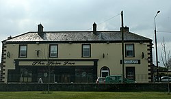
The Turn Inn, Derrinturn
Derrinturn is located in Ireland
Derrinturn
Derrinturn
Location in Ireland
Coordinates: 53°20′23″N 6°56′24″W / 53.33959°N 6.94010°W / 53.33959; -6.94010
CountryIreland
ProvinceLeinster
CountyCounty Kildare
Area
 • Total
2 km2 (0.8 sq mi)
Elevation
85 m (279 ft)
Population1,837
Time zoneUTC+0 (WET)
 • Summer (DST)UTC-1 (IST (WEST))
Irish Grid ReferenceN759266

Derrinturn (Irish: Doire an tSoirn, meaning 'oak wood of the furnace')[2] is a village in County Kildare, Ireland. It is part of the parish of Carbury. It is located about 60 km (37 mi) from Dublin.

The main road through Derrinturn is the R403 regional road.

The population was 1,837 as of the 2022 census, an increase of 1000% from 1961 when only 183 people lived in the village.[3][1]

Derrinturn has one Roman Catholic church and a primary school St. Conleth's (Naomh Connlaodh).[4]

Derrinturn townland has an area of 132.40 hectares (327.2 acres).[5] It borders the townlands of Ballyhagan to the west, Ballyshannon to the east, Coonagh to the east, Dreenan to the south, Newbury Demesne to the north, and Rathmore to the south.[5]

The Windmill, Derrinturn

See also

References

  1. ^ a b c "Interactive Data Visualisations: Towns: Derrinturn". Census 2022. Central Statistics Office. Retrieved 30 September 2023.
  2. ^ "Doire an tSoirn / Derrinturn". logainm.ie. Placenames Database of Ireland. Retrieved 5 October 2021.
  3. ^ a b "Derrinturn (Kildare, All Towns, Ireland) - Population Statistics, Charts, Map, Location, Weather and Web Information".
  4. ^ "St Conleth's National School". www.stconlethsns.ie. Retrieved 27 March 2019.
  5. ^ a b "Derrinturn Townland, Co. Kildare". www.townlands.ie. Retrieved 27 March 2019.
  6. ^ "Home - CSO - Central Statistics Office".
  7. ^ "Sapmap Area - Settlements - Derrinturn". Census 2016. CSO. April 2016. Retrieved 6 January 2020.