|
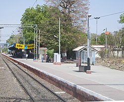
Babina, Uttar Pradesh
Babina is a cantonment town in Jhansi district in the state of Uttar Pradesh, India. Shree Rajeev Singh Parichha is MLA of Babina constituency. EtymologyIt is said that Babina is an anacronym originating from "British Army Base in North Asia". While this has been endorsed by the Cantonment Board of Babina,[1] it appears to be a backronym that has been endorsed without due verification. Contrary to what the alleged anacronym suggests, the cantonment at Babina had no association with the British Raj and was opened in 1959, 12 years after the British left India. Furthermore, India is considered to be a part of South Asia, not North Asia as the acronym suggests. This suggests that the popular anacronym is very likely a modern invention. Indian ArmyJhansi district is the headquarters of the 31st Indian Armoured Division, stationed at Jhansi-Babina. It is an armored division which has equipment like M3 Lee [Historian] and M4 Sherman tanks [Historian]. There was a joint exercise in 2012 with the Singaporean Army at Jhansi witnessed by the President of India, Pratibha Patil.[2] In 2019 the Indian army held a joint exercise with the Russian army at Babina Battlefield, involving T-90, 'Arjun', and T-72 tanks. GeographyBabina is located at 25°15′N 78°28′E / 25.25°N 78.47°E.[3] It has an average elevation of 303 metres (994 feet). Places to visit: Sukma Dukma Dam is a very beautiful one. This dam is located in Babina Jhansi city of Uttar Pradesh. One of the better places to visit near Jhansi during the rainy season. Sukma Dukma Dam is a British era dam, which was built in the first five year plan. This dam is 800 meters in length. The right time to visit this dam is during the rainy season. Because in the rainy season, the dam is completely filled with water and overflowing the water falls on the dam, which looks like a beautiful waterfall. Most of the people come to enjoy the beauty of the dam during the rainy season. Here is a very nice place for picnic. the dam is built on the Betwa river. DemographicsAs of the 2011 Census of India,[4] Babina had a population of 35,165. Males constitute 62% of the population and females 38%. Babina has an average literacy rate of 73%, higher than the national average of 59.5%; with 69% of the males and 31% of females literate. 13% of the population is under 6 years of age. References
|
||||||||||||||||||||||||||||||


