|
Shire of Shark Bay
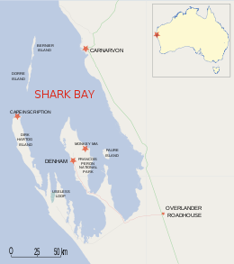
Shire of Shark Bay is een lokaal bestuursgebied (LGA) in de regio Gascoyne in West-Australië. Het bestuursgebied is bekend vanwege het op de werelderfgoedlijst geplaatste Shark Bay.  GeschiedenisOp 13 mei 1904 werd het Shark Bay Road District opgericht. Ten gevolge de Local Government Act van 1960 veranderde het op 23 juni 1961 van naam en werd de Shire of Shark Bay.[2] BeschrijvingShire of Shark Bay is een toeristisch kustdistrict in de West-Australische regio Gascoyne, bestaande uit twee schiereilanden. De economische activiteit bestaat hoofdzakelijk uit toerisme, visvangst, parelkweek, zoutproductie en pastoralisme.[3] Shark Bay staat op de Werelderfgoedlijst. Er liggen twee nationale parken in het district, Dirk Hartog Island en François Peron. In 2021 telde 1.031 Shire of Shark Bay inwoners. Net geen 10 % van de bevolking was van inheemse afkomst.[1] De hoofdplaats is Denham. Plaatsen, dorpen en lokaliteiten
Bevolkingsaantal
Bronnen, noten en/of referenties
|
||||||||||||||||||||||||||||||||||||||||||||||||||||||||||||||||||
