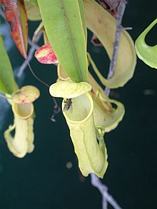
食虫植物のミソールウツボカズラ (英語版 ) ミソール島 (Misool )はインドネシア 、ラジャ・アンパット諸島 の主要4島の一つ。面積は2,034 km2 、最高地点は535mである。西パプア州 に属しており、島の北岸のワイガマ(Waigama)とリリンタ(Lilinta)が主要な街である。
ドベライ半島西端から西南西に70km程の位置に存在する。サラワティ島 、バタンタ島 、ワイゲオ島 等、諸島の他の主要島はドベライ半島 の近くに存在し、コフィアウ島 (英語版 ) [ 1]
住民はインドネシア語 のほかにMa'ya語 (英語版 ) マトバット語 (英語版 ) [ 2] [ 3]
ラジャ・アンパット諸島の他島と同じく希少な動植物が生息している。
近世以降欧州のオランダの植民地オランダ領東インドの一部であった。
1942年には日本軍によって占領され、1945年まで海軍の基地が存在した[ 6]
^ Traditional kingdoms of Maluku, early 15th century, and the spheres of influence of Ternate and Tidore, early 16th century ^ Ethnologue - Biga ^ Ethnologue - Matbat ^ Allen, G.R., Hadiaty, R.K. & Unmack, P.J. (2014): Melanotaenia flavipinnis , a new species of Rainbowfish (Melanotaeniidae) from Misool Island, West Papua Province, Indonesia, aqua, International Journal of Ichthyology, 20 (1): 35-52.
^ Allen, G. 1996. Melanotaenia misoolensis . 2006 IUCN Red List of Threatened Species. Downloaded on 4 August 2007.
^ No. 92 of the Japanese Monographs — "Southwest Area Naval Operations, Apr. 1942 – Apr. 1944", 10 September 1947.
座標 : 南緯1度53分41秒 東経130度5分1秒 / 南緯1.89472度 東経130.08361度 / -1.89472; 130.08361


