チェスターフィールド (イングランド)

チェスターフィールド
Chesterfield
イングランドの旗
位置
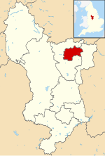
チェスターフィールドの位置の位置図
チェスターフィールドの位置
座標 : 北緯53度14分 西経01度25分 / 北緯53.233度 西経1.417度 / 53.233; -1.417
行政
イギリスの旗 イギリス
 連合王国 イングランドの旗イングランド
 リージョン イースト・ミッドランズ
 カウンティ ダービーシャー
チェスターフィールド
人口
人口 (2011現在)
  域 103,800人
その他
等時帯 西ヨーロッパ時間 (UTC+0)
夏時間 西ヨーロッパ夏時間 (UTC+1)
郵便番号 S40
公式ウェブサイト : www.chesterfield.gov.uk

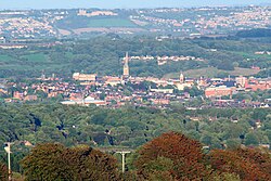
チェスターフィールド(Chesterfield)は、イングランドダービーシャー典礼カウンティにあるタウン。ダービーの北39km、シェフィールドの南18kmのロザー川英語版ヒッパー川英語版の合流地点にある。2011年時点の市街地区域の人口は88,483人で[1]、ダービーシャー州ではダービーに次いで2番目に大きな集落となった。2021年国勢調査では、より広いチェスターフィールド自治区の人口は103,569人であった[2]。2021年の時点で、町自体の人口は76,402人だった[3]

スポーツ

出身人物

脚注

  1. ^ Chesterfield”. City Population De. 3 November 2020閲覧。
  2. ^ Chesterfield (District, United Kingdom) - Population Statistics, Charts, Map and Location”. www.citypopulation.de. 5 April 2024閲覧。
  3. ^ Chesterfield (Derbyshire, East Midlands, United Kingdom) - Population Statistics, Charts, Map, Location, Weather and Web Information”. www.citypopulation.de. 5 April 2024閲覧。

外部リンク