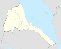
座標: 北緯15度33分 東経37度53分 / 北緯15.550度 東経37.883度 / 15.550; 37.883
アゴルダト(ゲエズ語:ኣቆርዳት、Agordat/Akordat/Ak'ordat)は、エリトリアの都市。ガシュ・バルカ地方に属し、かつてガシュ・バルカ地方とアンセバ地方の間に存在していたバルカ州の州都に定められていた。
アゴルダトはエリトリア西部に位置し、バルカ川の河岸に建つ。市の中心部にはハイレ・セラシエ1世によって建立された大モスクが存在する。
歴史
紀元前2500年頃から1500年頃にかけて遊牧民的な特徴を備えるCグループ(英語版)と呼ばれる文化グループがヌビアに居住していたが、アゴルダトからは彼らの文化と関連性のある陶器が発掘されている[1]。また、バルカ川の渓谷に存在するガシュ・グループの遺跡からは、Cグループと同時期にヌビアに存在したケルマ王国のものと共通する特徴を持った陶片が出土した
[2]。Peter Behrens、Marianne Bechaus-Gerstらの研究者は、Cグループとケルマ文化に属する民族はアフロ・アジア語族に属し、ベルベル語派、クシ語派に分類される言語を用いていたと言語学的な証拠から推定している[3][4]。
アゴルダトはイスラム教圏に属し、アスマラから西方に延びる鉄道の終着地として発達した[5]。
町にはレストラン、イタリア植民地時代に建てられた病院が建ち並ぶ。バナナ、オレンジなどのエリトリアで栽培された多量の果実・野菜は、アゴルダトを経由して各地に出荷されており、町ではAkat fruitが栽培されている。
気候
| アゴルダトの気候
|
| 月 |
1月 |
2月 |
3月 |
4月 |
5月 |
6月 |
7月 |
8月 |
9月 |
10月 |
11月 |
12月 |
年
|
| 平均最高気温 °C (°F)
|
32
(89)
|
33
(92)
|
36
(96)
|
39
(103)
|
40
(104)
|
37
(99)
|
33
(91)
|
32
(89)
|
35
(95)
|
37
(99)
|
36
(96)
|
33
(92)
|
35.3
(95.4)
|
| 平均最低気温 °C (°F)
|
14
(58)
|
14
(57)
|
14
(58)
|
18
(65)
|
22
(72)
|
22
(72)
|
21
(69)
|
21
(70)
|
21
(69)
|
21
(70)
|
19
(67)
|
16
(61)
|
18.6
(65.7)
|
| 降水量 mm (inch)
|
0
(0)
|
0
(0)
|
0
(0)
|
0
(0)
|
10
(0.39)
|
30
(1.18)
|
100
(3.94)
|
140
(5.51)
|
40
(1.57)
|
0
(0)
|
0
(0)
|
0
(0)
|
320
(12.59)
|
| 出典:Weatherbase [6]
|
脚注
- ^ Cole, Sonia Mary (1964). The Prehistory of East. Weidenfeld & Nicolson. p. 273
- ^ Leclant, Jean (1993). Sesto Congresso internazionale di egittologia: atti, Volume 2. International Association of Egyptologists. p. 402. https://www.google.com/books?id=0B1yAAAAMAAJ 15 September 2014閲覧。
- ^ Marianne Bechaus-Gerst, Roger Blench, Kevin MacDonald (ed.) (2014). The Origins and Development of African Livestock: Archaeology, Genetics, Linguistics and Ethnography - "Linguistic evidence for the prehistory of livestock in Sudan" (2000). Routledge. p. 453. ISBN 1135434166. https://www.google.com/books?id=-t5QAwAAQBAJ 15 September 2014閲覧。
- ^ Behrens, Peter (1986). Libya Antiqua: Report and Papers of the Symposium Organized by Unesco in Paris, 16 to 18 January 1984 - "Language and migrations of the early Saharan cattle herders: the formation of the Berber branch". Unesco. p. 30. ISBN 9231023764. https://www.google.com/books?id=p_hwAAAAMAAJ 14 September 2014閲覧。
- ^ 鈴木「アゴルダト」『世界地名大事典』6巻、11頁
- ^
“Weatherbase: Historical Weather for Ak'ordat, Eritrea”. Weatherbase (2011年). 2015年5月閲覧。
Retrieved on November 24, 2011.
参考文献
- 鈴木秀夫「アゴルダト」『世界地名大事典』6巻収録(朝倉書店, 1974年)
ウィキメディア・コモンズには、
アゴルダトに関連するカテゴリがあります。
