Younghusband Peninsula

Younghusband Peninsula
South Australia
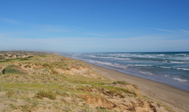
The ocean side of the Younghusband Peninsula is a popular area for fishing
Younghusband Peninsula is located in South Australia
Younghusband Peninsula
Coordinates35°35′8″S 138°57′18″E / 35.58556°S 138.95500°E / -35.58556; 138.95500

Younghusband Peninsula is a long narrow peninsula in South Australia. It separates the Coorong Channel, the Tauwitchere Channel and the Coorong which are part of the estuary of the River Murray from the Southern Ocean which including water bodies such as Encounter and Lacepede Bays. It lies entirely within the Coorong National Park. The peninsula is over [citation needed] 110 kilometres (68 mi) long, but less than 3 kilometres (1.9 mi) wide at its widest point. Its narrowest point is less than 350 metres (1,150 ft) wide. The Younghusband Peninsula, together with the Sir Richard Peninsula on the western side of the Murray Mouth, are the coastal dune system that forms the continental coastline from near Goolwa in the north west to about 35 kilometres (22 miles) north of Kingston SE in the south east. Younghusband Peninsula was named after William Younghusband, M.P.[1][2][3][4]

References

  1. ^ "Younghusband Peninsula, South Australia". PlaceNames Online: Gazetteer of South Australia. Government of South Australia. Archived from the original on 1 October 2007. Retrieved 19 October 2006.
  2. ^ "Younghusband Peninsula". Gazetteer of Australia online. Geoscience Australia, Australian Government.
  3. ^ "Coorong National Park Brochure" (PDF). Department of Environment Water and Natural Resources. p. 6. Retrieved 19 January 2015.
  4. ^ Boating Industry Association of South Australia (BIA); South Australia. Department for Environment and Heritage (2005), South Australia's waters an atlas & guide, Boating Industry Association of South Australia, pp. 27, 30, 31, 181&182, ISBN 978-1-86254-680-6