Vyg

Vyg
Map
Native nameВыг (Russian)
Location
CountryRussia
RegionRepublic of Karelia
CityBelomorsk
Physical characteristics
Source 
 • coordinates62°41′38″N 36°38′56″E / 62.69389°N 36.64889°E / 62.69389; 36.64889
MouthOnega Bay
 • location
Republic of Karelia, Russia
 • coordinates
64°31′32″N 34°47′22″E / 64.52556°N 34.78944°E / 64.52556; 34.78944
 • elevation
0 m (0 ft)
Length237 km (147 mi)
Basin size27,100 km2 (10,500 sq mi)
Discharge 
 • locationVorozhgora
 • average267 m3/s (9,400 cu ft/s)
Discharge 
 • locationOnega Bay
 • average?

The Vyg (Russian: Выг; Karelian: Uikujoki) is a river in the Republic of Karelia, Russia. It consists of the Upper Vyg which is 135 kilometres (84 mi) long and discharges into Lake Vygozero,[1] and the Lower Vyg, which is 102 kilometres (63 mi) long and flows from Vygozero and discharges into Onega Bay of the White Sea near Belomorsk.

The Upper Vyg flows through several small lakes in a swampy land. The Lower Vyg is a part of the White Sea–Baltic Canal and is controlled by several dams.
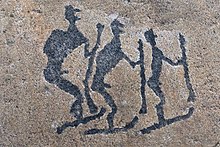
A petroglyph in Zalavruga [ru]

Neolithic petroglyphs have been found [ru] on islands of Vyg near its mouth.

There were famous raskolnik monasteries along Vyg and its tributary Leksa [ru], notably the Vyg River Hermitage [ru] (also Vygoretskaya Hermitage)[2][3]

References

  1. ^ Река Выг (Верхний Выг) citing Ресурсы поверхностных вод СССР: Гидрологическая изученность. Том 2. Карелия и Северо-Запад / под ред. Е. Н. Таракановой. — Л.: Гидрометеоиздат, 1965.
  2. ^  "Выг" . Brockhaus and Efron Encyclopedic Dictionary (in Russian). 1906.
  3. ^  "Выгорецкая или Выговская пустынь" . Brockhaus and Efron Encyclopedic Dictionary (in Russian). 1906.