Tchefuncte River Range Lights

Tchefuncte River Range Lights
Map
LocationSt. Tammany Parish, US
Coordinates30°23′N 90°10′W / 30.38°N 90.17°W / 30.38; -90.17
Tower
Constructed1838 Edit this on Wikidata
Tchefuncte River Range Rear Light Edit this at Wikidata
Constructionbrick (tower), stone (foundation) Edit this on Wikidata
Automated1952 Edit this on Wikidata
Height16 m (52 ft) Edit this on Wikidata
Shapeconical Edit this on Wikidata
Markingswhite (tower), black (vertical stripe), black (lantern) Edit this on Wikidata
HeritageNational Register of Historic Places listed place Edit this on Wikidata
Fog signalnone now, bell in past
First lit1868 Edit this on Wikidata
Focal height49 ft (15 m) Edit this on Wikidata
Lens5th order Fresnel lens (original), 9.8 inches (250 mm) (current)
Range15 nmi (28 km; 17 mi) Edit this on Wikidata
CharacteristicIso W 6s Edit this on Wikidata
Tchefuncte River Range Rear Light
Nearest cityMadisonville, Louisiana
Area0.1 acres (0.040 ha)
Built1867
NRHP reference No.86001684[1]
Added to NRHPJuly 14, 1986
Tchefuncte River Range Front Light Edit this at Wikidata
ShapeSkeleton tower
Markings KRW
Focal height25 ft (7.6 m) Edit this on Wikidata
Lensfourth order Fresnel lens Edit this on Wikidata
CharacteristicQ W Edit this on Wikidata

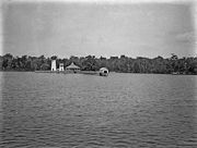
The Tchefuncte River Range Lights are a range that was first established in 1838 to aid vessels entering the Tchefuncte River from the north side of Lake Pontchartrain, Louisiana. The lighting apparatus was supplied by Winslow Lewis and consisted of nine lamps with several fourteen-inch reflectors. The original rear tower suffered during the Civil War and was replaced with the current tower in 1868. The new tower, ten feet taller than the first, was built on the same foundation, using some of the same brick. It was given a lantern which had been removed from Cat Island Light in Mississippi.

The rear tower has a black vertical stripe to serve as the range line in daytime.[2][3][4] It sits on a spit of land, but is accessible only by boat. The front tower is marked with a standard USCG KRW daymark, with a red stripe between two white stripes. It is a skeleton tower and sits in open water.

The rear tower was added to the National Register of Historic Places in 1986. The Maritime Museum Louisiana is making efforts to restore and stabilize the light.[5]

See also

References

The Light List [2] spells the river name "Tchefuncta", but that's in conflict with the U.S. Board on Geographical Names [6]

  1. ^ "National Register Information System". National Register of Historic Places. National Park Service. March 13, 2009.
  2. ^ a b Light List, Volume IV, Gulf of Mexico (PDF). Light List. United States Coast Guard. 2009. p. 84.
  3. ^ "Historic Light Station Information and Photography: Louisiana". United States Coast Guard Historian's Office. Archived from the original on 2017-05-01.
  4. ^ Rowlett, Russ (2010-01-06). "Lighthouses of Louisiana". The Lighthouse Directory. University of North Carolina at Chapel Hill.
  5. ^ "The Tchefuncte River Light Station". Maritime Museum Louisiana. Retrieved 6 January 2010.
  6. ^ "Feature Detail Report for: Tchefuncte River". USGS Geographic Names Information System. Retrieved 6 January 2010.