|
Summit, Oklahoma
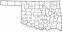
Summit is a town in Muskogee County, Oklahoma, United States. It was originally called South Muskogee when it was platted in 1910, and is one of thirteen all-black towns still surviving at the beginning of the 21st century.[4] The population was 139 at the 2010 census, a 38.5 percent decline from the figure of 226 recorded in 2000.[5] Summit, is located in Muskogee County six miles southwest of the city of Muskogee. The community retained a post office as early as 1896. Like many of the other Black towns previously mentioned, was a stopover destination on the Missouri, Kansas and Texas Railway and had a depot in the community. It is said that the town may have been named Summit because it was the highest point on the railroad between Arkansas and the North Canadian rivers. GeographyAccording to the United States Census Bureau, the town has a total area of 0.9 square miles (2.3 km2), all land. Summit, situated 617 feet above sea level and is completely made up of land. It is approximately 35.40° N latitude and 95.25° W longitude, and geographically it falls to the east part of the state, proximal to the Arkansas River Basin. The surroundings are mostly flat to gentle, rolling landscapes typical of the Great Plains, with fairly rich soil for good farming. While there are no significant bodies of water around this town, its proximity to both the Verdigris and Arkansas Rivers influences the regional ecology and hydrology. Summit’s landscape is a flat and gently rolling land that typifies eastern Oklahoma, with agricultural field interspersed with residences. Its climate is humid subtropical. Hot summers and mild winters are the usual pattern throughout most of Oklahoma. Summit’s proximity to Muskogee has the benefit of providing more urban amenities without compromising its identity as a small community. Demographics
As of the census[3] of 2000,[needs update] there were 226 people, 66 households, and 54 families residing in the town. The population density was 247.8 inhabitants per square mile (95.7/km2). There were 73 housing units at an average density of 80.0 per square mile (30.9/km2). The racial makeup of the town was 84.07% African American, 5.75% White, 3.98% Asian, 1.33% Native American, 0.44% Pacific Islander, and 4.42% from two or more races. Hispanic or Latino of any race were 1.77% of the population. There were 66 households, out of which 42.4% had children under the age of 18 living with them, 59.1% were married couples living together, 18.2% had a female householder with no husband present, and 16.7% were non-families. 15.2% of all households were made up of individuals, and 10.6% had someone living alone who was 65 years of age or older. The average household size was 3.42 and the average family size was 3.60. In the town, the population was spread out, with 42.0% under the age of 18, 11.9% from 18 to 24, 18.1% from 25 to 44, 16.4% from 45 to 64, and 11.5% who were 65 years of age or older. The median age was 22 years. For every 100 females, there were 76.6 males. For every 100 females age 18 and over, there were 74.7 males. The median income for a household in the town was $17,917, and the median income for a family was $15,625. Males had a median income of $16,563 versus $11,875 for females. The per capita income for the town was $6,390. About 34.5% of families and 47.5% of the population were below the poverty line, including 65.2% of those under the age of eighteen and 10.0% of those 65 or over. Of persons 25 years of age and above in Summit, an approximate 59.7% have at least a high school diploma and at least 1.5% hold a bachelor’s degree. Residents five years of age and above, 2.1% speak non-English languages at home and 1.0% of them speak Spanish. With 23.3% of the non-military workers occupied in government activities, the unemployment rate remains at 23.1%. With 90.3% of the units owned and 9.7% rented, Summit’s housing is essentially owner-occupied. Historic SitesNRHP-listed sites in Summit include:
See also
References
|
||||||||||||||||||||||||||||||||||||||||||||||||||||||||||||||

