Sotta

Sotta
Sotta
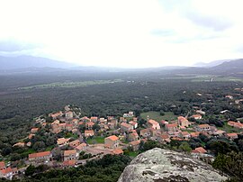
A panoramic view of Sotta from Punta
Location of Sotta
Map
Sotta is located in France
Sotta
Sotta
Sotta is located in Corsica
Sotta
Sotta
Coordinates: 41°32′44″N 9°11′44″E / 41.5456°N 9.1956°E / 41.5456; 9.1956
CountryFrance
RegionCorsica
DepartmentCorse-du-Sud
ArrondissementSartène
CantonGrand Sud
Government
 • Mayor (2020–2026) Jean-Marc Serra[1]
Area
1
67 km2 (26 sq mi)
Population
 (2021)[2]
1,711
 • Density26/km2 (66/sq mi)
Time zoneUTC+01:00 (CET)
 • Summer (DST)UTC+02:00 (CEST)
INSEE/Postal code
2A288 /20146
Elevation17–1,298 m (56–4,259 ft)
(avg. 100 m or 330 ft)
1 French Land Register data, which excludes lakes, ponds, glaciers > 1 km2 (0.386 sq mi or 247 acres) and river estuaries.

Sotta (Corsican pronunciation: [ˈsɔtːa]) is a commune in the French department of Corse-du-Sud, on the island of Corsica. It is one of communes in the canton of Grand Sud.

Geography

Sotta is 15 kilometres (9 mi) to the northeast of the commune of Figari on the road to Porto-Vecchio; it was created in 1853. The territory includes part of 1,299 metres (4,262 ft) Mount Cagna to the northwest; the remainder is in a plain scattered with hamlets, vines and groves of Cork Oak and Eucalyptus.[3]

Population

Historical population
YearPop.±% p.a.
1968 578—    
1975 683+2.41%
1982 726+0.88%
1990 762+0.61%
1999 808+0.65%
2009 956+1.70%
2014 1,207+4.77%
2020 1,556+4.32%
Source: INSEE[4]

Transportation

The village is near the airport at Figari.

It has been used as a special stage in the Tour de Corse.

See also

References

  1. ^ "Répertoire national des élus: les maires". data.gouv.fr, Plateforme ouverte des données publiques françaises (in French). 2 December 2020.
  2. ^ "Populations légales 2021" (in French). The National Institute of Statistics and Economic Studies. 28 December 2023.
  3. ^ "France, le trésor des régions: Département: Corse-du-Sud" (in French). Retrieved 6 May 2008..
  4. ^ Population en historique depuis 1968, INSEE