|
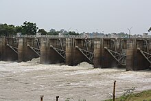
Rasi Salai districtGeographyNeighboring districts are (from the north clockwise): Phanom Phrai of Roi Et province; Sila Lat of Sisaket Province; Maha Chana Chai and Kho Wang of Yasothon province; Yang Chum Noi, Mueang Sisaket, Uthumphon Phisai, and Bueng Bun of Sisaket; and Rattanaburi of Surin province. The main river of the district is the Mun. HistoryThe district was renamed from Khong to Rasi Salai in 1939.[1] The Rasi Salai Dam was built here in 1994 and unofficially decommissioned in July 2000 following devastation of local farming villages as documented by Living River Siam.[2] AdministrationThe district is divided into 13 sub-districts (tambons), which are further subdivided into 190 villages (mubans). Mueang Khong is a township (thesaban tambon) and covers parts of tambon Mueang Khong. There are a further 13 tambon administrative organizations (TAO).
Missing numbers are tambons which now form Sila Lat District.  References
External links
|
